
1699-1755.
Se Longman & Co.
Carl Van Verden (fl. c. 1718 - 1730) was a Dutch seaman in the employ of the Russian Navy during the early 18th century. Van Verden is best known for his important 1719 - 1721 mapping of the Caspian Sea, which was the most sophisticated and accurate that had been issued to date. A significant cartographic achievement, Van Verden's work on the Caspian led directly to Peter the Great's 1722 invasion of Baku and Derbent and Russian hegemony in the region. Despite his achievements in the Caspian, Van Verden was later passed up by the Tzar in favor of Vitus Behring for the commission to discover a Northeast Passage through the Russian Arctic.
Around 1718 the Russian Tzar, Peter the Great, sponsored a number of cartographic expeditions to the farthest reaches of his vast empire. Most of these were headed up by Dutch navigators, the most experienced and mercenary of the era. Carl Van Verden, a Dutch seaman, was commissioned as a Russian naval officer and assigned the task of mapping the Caspian Sea. Though we...
Bland arbeten.
Carte Marine de la Mer Caspiene.
(c. 1596, Neuhausen, – 1665, Hoorn)
Cellarius was a Dutch-German cartographer, best known for his Harmonia Macrocosmica of 1660, a major star atlas, published by Johannes Janssonius in Amsterdam.
He was born in Neuhausen (now a part of Worms), and was educated in Heidelberg. The Protestant Cellarius may have left Heidelberg at the onset of the Thirty Years' War in 1618 or in 1622 when the city came in Catholic hands. His activities are unclear at this time but based on his later works it is conjectured he spent time in Poland and may have even worked as a military engineer there. In 1625 he married Catharina Elt(e)mans in Amsterdam, where he worked as school master of a Latin School. After a brief stay in The Hague, the family moved to Hoorn. From 1637 until his death he was rector of the Latin School in Hoorn, where Pieter Anthoniszoon Overtwater was conrector.
He published on fortification and on Poland.
The minor planet 12618 Cellarius is named in his honour.
Andreas Cellarius
The Dutch-German mathematician and cosmogr...
Bland arbeten.
Harmonia macrocosmica sea atlas universalis et novus. Amsterdam: G. Valck and P. schenk, 1708.
Folio (530 x 320mm), allegorical title engraved by F. H. van Hoven, printed in red and black with woodcut vignette, letterpress title with contents and 29 double-page engraved cosmographical charts finely coloured by hand, without text.
One of the most fascinating achievement from the golden age of Dutch cartography. The Harmonia macrocosmica is the only atlas of the period dealing with astronomy.
Unlike the late celestial atlases, the Cellarius charts demonstrated various ancient and contemporary cosmological ideas, rather than just the names and positions of the stars. The purpose of the book was to assess different attempts to discover the underlying harmony of the universe. The charts represent the highest levels of seventeenth-century astronomical thought, with the diagram showing aspects of the three great theories on the nature of the universe; the Ptolemaic, the Copernican and the Brahean.
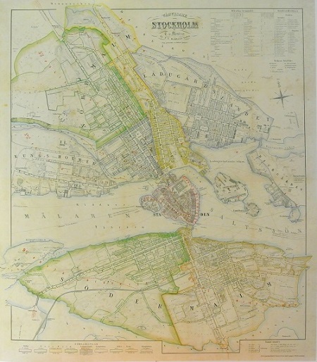
Stockholm - Mentzer ca 1860.
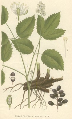
Trolldruva, Actća spicata - Lindman, C. A. M, Bilder ur Nordens Flora 1917-26.
Olaus Magnus text till den berömda kartan "Carta Marina".
Texten finns även pĺ katalanska, spanska och engelska.
Bureus karta över norden
Kartor och atlaser
Bilder och planschverk
Teckenförklaringar
Förkortningar av kartografer använda av Olof Rudbeck i "Atlantica".
"Olf Rudbeks Atland eller Manheim 1675" (sidor frĺn Nelson, Axel upplaga 2939)
Sid 97.
[Blau Atlant
Vol. 2. f. I
fol. 3. fol. 25.
V.1
Piscat: Tab
Cluv. Germ
Burei
Janhson.]
Sid 98.
[Blau Atlant Vol 1 orb.terr
Orb.Ant f. 1. Vol. 1
Vol. 2. f. I
Hindrik Donkerz Tab 3
Du-Vals
Ortel.
Mercat.
Burei.
Theunis Jacobson
Lucas Vagenar in Marg. not:
Johan von Loon.]
Sid 100.
[Blavii Atlas Vol 2.fol 1
fol 3
fol.27
fol.19
Sanson de Abbeville
Piscat]
