
1777 - 1821
Rota was an italian miniaturist staying in Sweden 1806 to 1817.
Hammarlund
Ca. 1727-96. Avled i Porsgrunn, stad i Telemark fylke.
Norsk skeppare och navigationslärare. Fick borgerskap 1755 i Porsgrunn som köpman och skeppare. 1781 utnämnd till navigationsinformator i Porsgrunn och 1790 anställdes han som navigationseximinator i Langesunds tulldistrikt. Förutom ett sjökort över Nordsjön gav han 1787 ut 'Et nyt, og i Mange maader Forbedret Plat Soe Carte over den syndre Deel af Nord-Soen', och möjligen även en karta över Kattegatt 1869. 1790 arbetade han med en Skagerack-karta.
Bland arbeten.
Et nyt, og i Mange maader Forbedret Plat Soe Carte over den syndre Deel af Nord-Soen.
HURTER [HURTERO], JOHANN CHRISTOPH.
Alemannia siva Sueaviae superioris Choro. 1625, used by Blaeu 1634 & c.
Bland arbeten.
Alemannia siva Sueaviae superioris Choro.
Tooley.
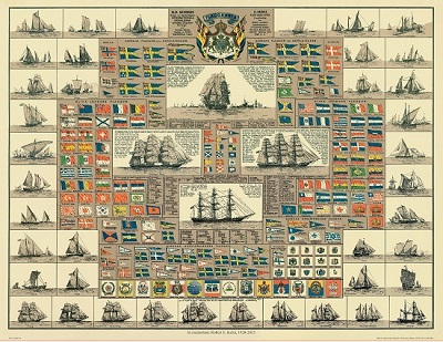
Amiral Häggs flaggkarta. - Stockholm 1888.
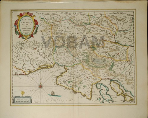
Carniola, Friuli, Istrien. - Blaeu 1643/44.
Olaus Magnus text till den berömda kartan "Carta Marina".
Texten finns även på katalanska, spanska och engelska.
Bureus karta över norden
Kartor och atlaser
Bilder och planschverk
Teckenförklaringar
