
Brittisk amatörtecknerska. Oidentifierad.
GIGAS [GIGANTE, GIGUS] JOANNES [IOANNE] MICHAEL.
1580-1650+.
Doctor, mathematician and geographer.
Bland arbeten.
Atlas of Archbishopric of Cologne 1620 (maps used later by Blaeu & Hondius), Paderborn, J. Hondius (pre-1629), Osnabrug, Westphalia, Munster, Hildesheim – all n.d.
Tooley.
Bland arbeten.
Encyclopédie ou dictionnaire universel raisonné des connaissances humaines.
Amiral Häggs flaggkarta. - Stockholm 1888.
Häger - Olof Rudbeck d.y.
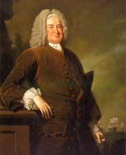
"Norris, Sir John, engelsk amiral (o. 1660-1749), deltog som fartygsbefälhavare i sjöstriderna pĺ 1690-talet och under 1700-talets första ĺr, blev 1708 viceamiral och lĺg 1709 utanför Helsingör med uppdrag att hindra fransk spannmĺlsinförsel frĺn östersjöhamnarna. 1709 amiral, var han 1710-11 överbefälhavare för Medelhavsflottan, 1715, 1716 och 1718 befälhavare för de till Östersjön sända engelska flottor, som avsĺgo att öva press pĺ Sverige. Efter Karl XII:s död sändes han ĺnyo till Östersjön för att mota de ryska planerna mot Sverige men lyckades ej förhindra ryssarnas härjningar pĺ den svenska östkusten och intog i det hela en passiv hĺllning. 1734-44 var han överbefälhavare för engelska flottan."
ur Svensk Uppslagsbok, band 21.
A Compleat Sett of New Charts,
Containing
The North-Sea, Cattegatt, and Baltick; wherein the Headlands, Islands, Soundings, Banks, Shoals and Dangers are laid down in their proper Places, and the Errors of the former Charts Corrected, by the Observations of the British Officers belonging to the Squadron employ'd in those Seas.
Also
Draughts of several particular Parts of the Coast, which contain Roads, Bays, Harbours, Fuers and Passages at large, being Preferable to any one of this Kind heretofore Published.
The Whole Collected together, Revised and approved of by Sr. John Norris, Kt. Admiral of the Blew, &c. Who commanded the British Squadron employ'd in those Seas several Years; and Published by His Order.
London:
Printed for Thomas Page, William and Fisher Mount at the Postern on Tower Hill.
MDCCXXVIII.
Dedikation
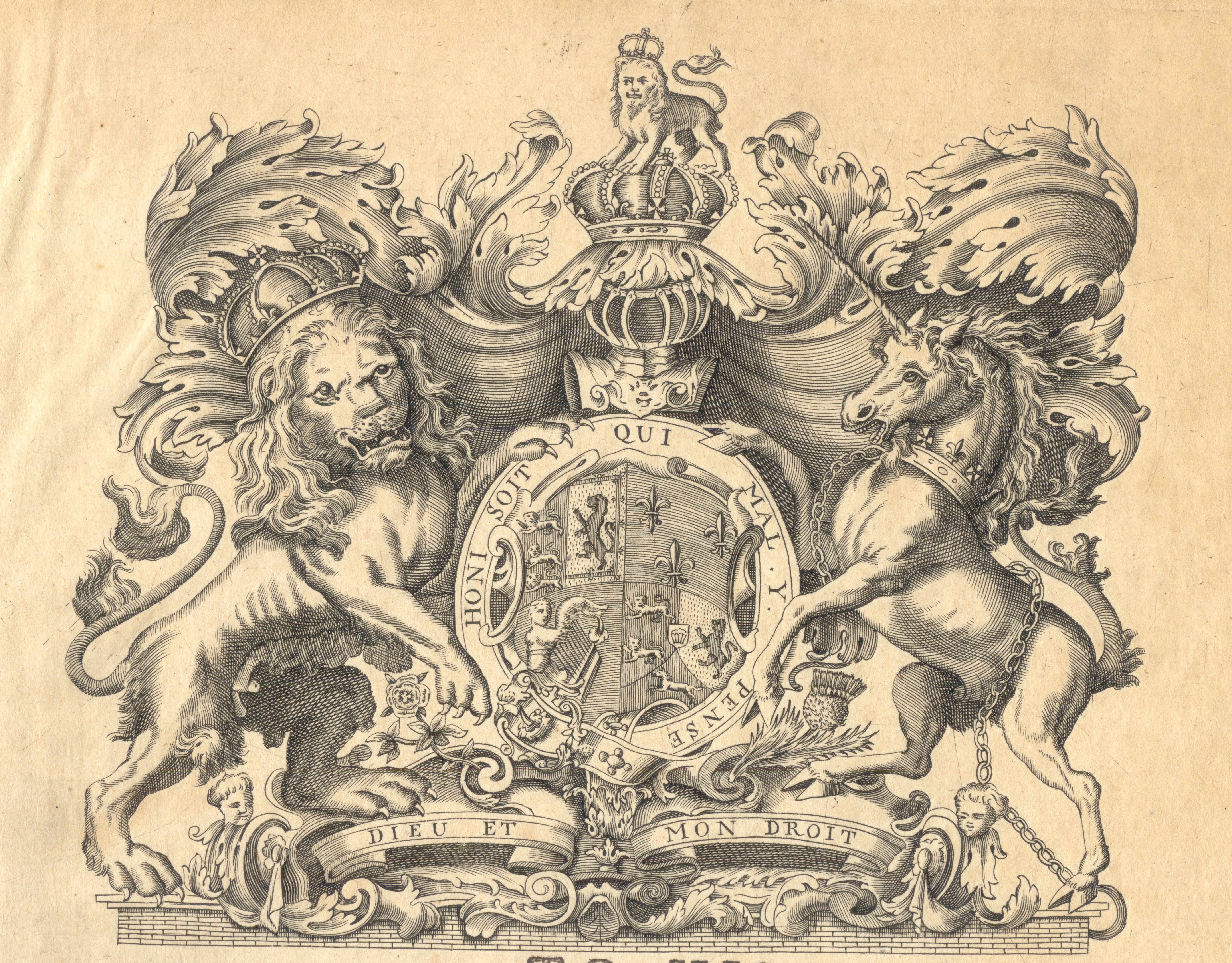
To His
Sacred Majesty
George,
Of Great-Britain, France, and Ireland,
King.
Sir,
Your Majesty having been graciously pleased during the Troubles in the North, to send into the Baltick, for the Protection of your Subjects Trading thither, a Squadron of your Ships: Your Majesty's Officers finding from their Observations in those Voyages, that there were several Errors in the present Charts of those Seas, we have corrected as many of them as have come to our Knowledge, and believing this to be the most perfect Sett of Charts now extant and that they may be of Use to the British Navigation in those Parts; I most humbly beg leave in the Name of your Sea Officers who served there to Present it to your most excellent Majesty.
I am
Your Majesty's most Dutiful,
Most Obedient and most
Humble Servant,
John Norris
"A General Draught of the Baltick:"
"A General Draught of the Baltick: Laid down from the Observations of the Brittish Officers; and collected By the Order of Sr. Iohn Norris."
Originalet tryckt i London 1728, rekognoserad ĺr 1721. Kartan sträcker sig frĺn Lübeck i väst till S:t Petersburg i öst och frĺn Bohus, Stockholm, Hangö i norr till och med hela Danzigbukten i syd. Kuststräckorna som berörs är den danska östkusten, hela tyska och polska kusten, Baltikum, Finska viken samt östersjöns öar och svenska kusten frĺn Bohus till Stockholm.
I nedre högra hörnet en infälld karta över "A Draught of the Harbour of Revel". Den infällda kartan är orienterad, tvärt emot övriga kartan, med söder uppĺt. Den omfattar Tallinnbukten med öarna "Wolf" och "Nargin".
Originalkartan är ej kolorerad.
Storlek: 138 X 62 cm. Kartytans bredd x höjd.
VÖBAM's faksimil utförs pĺ akvarellpapper och handkoloreras.
En rolig, intressant och vacker karta över hela Östersjöomrĺdet.
"A Draught of the Baltick from Copenhagen to Derwinck."
Storlek: 100x60 cm. Kartytans bredd x höjd.
Kartan reparerad.
Kartan sträcker sig frĺn Själlands kust med Köpenhamn, Kronborg, Helsingör i väst till Kurländska kusten i öst. Stralsund och Danzig i syd och Visby i norr.
"A Draught of the Baltick from the Rose Head to the Island Dago."
Storlek: 89x50 cm. Kartytans bredd x höjd.
Kartan orienterad med nord ĺt vänster.
Kartan visar Stockholm i norr, hela Gotland, städerna Danzig och Königsberg i syd, hela Kurska näset samt halva Ösel och Dagös spets. Utmärkt pĺ kartan är även "Duke Alvins castle" och "Lockscarts chappel".

"A Draught of the Baltic from the Isle of Oeland to Reval including Gothland, Riga."
Originalet tryckt i London 1728, rekognoserad ĺr 1721. Frĺn Stockholm - Gotland - Öland till Baltiska kusten med Tallinn - Riga - Dagö - Ösel - Runö. Originalkartan är ej kolorerad.
Storlek: 76 X 52 cm. Kartytans bredd x höjd.
VÖBAM's faksimil utförs pĺ akvarellpapper och handkoloreras.

"A General Draught of the Gulf of Bothnia and Part of the Gulf of Finland."
Text under arbete.
"A New Chart of the North Sea..."
"A New Chart of the North Sea: Wherein the Head Lands are laid down From Actual Observations and the Sands and Soundings more exactly taken & places than in any Draught of the same extant; done by order of S:r Iohn Norris."
"Engrav'd b y Em: Bowen. Printed for & Sold by Page and Mount on Tower Hill London."
Storlek: 70x77 cm. Kartytans bredd x höjd.
Kartan sträcker sig frĺn östra England med städerna London och Dover, i norr Shetlandsöarna, pĺ kontinenten är Calais och Dunkirk utmärkt, i öst sträcker sig kartan över hela Jylland.
Slite hamn och Kappelshamnsviken.
"A Draught of Slithamn Harour or Bay on the East side of Gothland.", "A Draught of Caples Wyk or Bay."
Storlek: 53x40 cm. Kartytans bredd x höjd.
Med bland annat "A watering place" utsatt, detta visar kartornas praktiska betydelse för brittiska flottan och dess försörjningsmöjligheter.
"A Draught of the Road of Hanno before Carlshaven."
Storlek: 40x44 cm. Kartytans bredd x höjd.
Hanöbukten med Blekinges kust, bland annat är den gamla danska staden Elleholm utsatt.
"A Draught of Carlscrone in Sweden."
Originalet tryckt i London 1728, rekognoserad ĺr 1721. Den originalkarta av "Fulvädersjacks" spionkarta som vi utför faksimilier av är skadat av brand i vänster och höger delar. Lätt förlust av bilden pĺ tvĺ av fartygen till vänster pĺ kartan. Lätt bruntonad mitt pĺ bilden. Originalkartan är ej kolorerad. Kartyta: 54,5 X 44 cm.
Pĺ faksimiltrycket syns samma skada som pĺ originalet. Skadan tillkommen vid en fartygsbrand.
VÖBAM's faksimil utförs pĺ akvarellpapper och handkoloreras.
"A Draught of the Island of Bornholm."
Storlek: 38x54 cm. Kartytans bredd x höjd.
En mycket vacker och tilltalande karta över Bornholm.
"A Draught of the Road of Hangóó in Finland."
Storlek: 52x40 cm. Kartytans bredd x höjd.
Finska Hangö med Hangö kyrka utmärkt.
"A Draught of the Harbour of Crownslote."
Storlek: 60x51 cm. Kartytans bredd x höjd.
Infälld plan över Kronstadts hamn.
VÖBAM's faksimil utförs pĺ akvarellpapper och handkoloreras.
Kartan sträcker sig frĺn östra Björkö förbi Kronstadt i mitten till och med S:t Petersburg i öst.
Slottet Peterhof utsatt bl.a.

"A Draught of the Passage of Stockholm from Landsort to Suderarmen..."
"A Draught of the Passage of Stockholm from Landsort to Suderarmen with the remarkable Rocks & Islands Sea-ward".
Originalet tryckt i London 1728, rekognoserad ĺr 1721. Sjökortet sträcker sig frĺn Landsort till Furusund. Originalkartan är ej kolorerad.
Storlek: 76x68 cm. Kartytans bredd x höjd.
Pĺ faksimiltrycket syns samma skada som pĺ originalet. Skadan tillkommen vid en fartygsbrand.
VÖBAM's faksimil utförs pĺ akvarellpapper och handkoloreras.

"A Draught of the Passage of Stockholm from Landsort to Dollers Castle."
Originalet tryckt i London 1728, rekognoserad ĺr 1721. Dollers Castle avser Dalarö skans. Originalkartan är ej kolorerad.
Storlek: 46 X 32 cm. Kartytans bredd x höjd.
VÖBAM's faksimil utförs pĺ akvarellpapper och handkoloreras.
"A Large Draught of the Passage of Stockholm from Suderarmen to the Doller's Castle."
Vaxholm i övre kanten. Norr ĺt höger. Dalarö i vänstra kanten. Kapellskär i högra kanten. Söderarm i nedre kanten.
Storlek: 66x61 cm. Kartytans bredd x höjd.
VÖBAM's faksimil utförs pĺ akvarellpapper och handkoloreras.
"A Draught of Part of Norway and Jutland..."
"A Draught of Part of Norway and Jutland From the Naze to Ieofferland Island in Norway and from the Holmes to the Scaw On the Coast of Jutland."
Storlek: 56x59 cm. Kartytans bredd x höjd.

"A Draught of the Cattegute..."
"A Draught of the Cattegute and Part of Norway from the Isle of Mardow to the Koll and from the Holmes to the Scaw & Elsinore & c...."
Originalet tryckt i London 1728, rekognoserad ĺr 1721. Sjökortet är orienterat med öster uppĺt. Det sträcker sig frĺn Oslo i norr (vänster) till Ven i söder (höger) och i öst-västlig riktning frĺn Holmes i väst till Göteborg och Laholm i öst. Originalkartan är ej kolorerad.
Storlek: 100 X 62 cm. Kartytans bredd x höjd.
VÖBAM's faksimil utförs pĺ akvarellpapper och handkoloreras.
Göteborg, Wismar, Stralsund, Greifswald, Hakefjorden.
Fem kartor pĺ ett blad.
Storlek: 46x51 cm. Kartytans bredd x höjd.
"A large chart of the Sound and Belt."
Storlek: 73x63 cm. Kartytans bredd x höjd.
Kartan visar hela Jyllands kust, Stralsund, Malmö samt hela Själland. De tyska städerna Wismar, Rostock och Lübeck är även utsatta pĺ kartan.
Storlek: 70x51 cm. Kartytan, bredd x höjd.
VÖBAM's faksimil utförs pĺ akvarellpapper och handkoloreras.
Kartan är orienterad med norr ĺt höger. Helsingör och Helsingborg i norr, Köpenhamn i mitten och Falsterbo i syd.
