
JACOBSZ, THEUNIS (eller ANTHEUNIS).
Ca. 1607-50. Född och död i Amsterdam.
c. 1606-50
JACOB JACOB5Z (LOOTSMAN) (son) d. 1679
Holländsk kartograf. Han var boktryckare och bokhandlare. 1648 gav han ut 't'Nieuw groot Straets-boeck, inhoudende d'Middelantse Zee'. Efter sin död gav sonen Jacob Theunisz (se denne) ut 't'Nieuwe en vergroote Zeeboeck, dat is des Piloots ofte Lootsmans Zee-Spiegel, inhoud de Zee-kusten vande Noordsche, Oosterzee ende Westersche Schipvaert' (1653). Båda dessa atlaser kom senare i flera utgåvor.
Anthonie Jacobsz founded a printing and publishing business in Amsterdam in which he specialized in the production of pilot books and sea atlases. As he died at a comparatively early age most of the numerous editions of his works appeared after his death published by his sons, Jacob and Caspar, who took the name 'Lootsman' (sea pilot) to distinguish them from another printer of the name Jacobsz.
Following Blaeu and Colom, Anthonie Jacobsz was the most important compiler of sea charts in Amsterdam in the first half of the seventeenth century. In his new ZeeSpiegel issued in 1643 he increased the number of ch...
Bland arbeten.
t'Nieuw groot Straets-boeck, inhoudende d'Middelantse Zee.
t'Nieuwe en vergroote Zeeboeck, dat is des Piloots ofte Lootsmans Zee-Spiegel, inhoud de Zee-kusten vande Noordsche, Oosterzee ende Westersche Schipvaert.
Kleerkooper. - Phillips.
Sophianos was well known as an expert on Greek history and geography. He was sent to Greece in about 1543 by Don Diego Hurtado de Mendoza, the Spanish envoy to Venice, to acquire Greek manuscripts for the Escurial Library. It is about this time – possibly in 1540, the date found at the end of Sophianos text on this map – that Sophianus compiled his great map of Greece, although there is no surviving example.
In 1544, Johann Oporinus, a printer and publisher in Basle, published an eight-sheet version of Sophianos map, cut by Master Christoph of Strasburg. Of this earliest printing, there is also no known extant example. Indeed, the earliest surviving printing of the map recorded by Zacharakis or Karrow was printed by Johann Schroeter in Basle in 1601.
It appears that Oporinus reprinted the map in 1545 to accompany his edition of Gerbelius “In Descriptionem Graeciae Sophiani, Praefatio….”. Although the book gives instructions on colouring the map, and contains additional gazetteer, the map seems not to ha...
Bland arbeten.
Descriptio nova totivs Graeciae per Nicolavm Sophianvm. Basle, 1544-1545, large woodcut wall-map of Greece, on eight sheets uncut, each sheet approx. 380 x 280mm., with an additional sheet with letterpress gazetteer. Of great rarity. The earliest surviving wall-map of Greece and the first significant modern map of Greece, compiled by Nickolaos Sophianos, a Greek cartographer from Corfu, born of a noble family there. This example is apparently the second state of the map. It retains the date 1544 just above the scale bar on the bottom right hand skeet, but the letterpress text in the left hand cartouche on the lower left sheet may have been reset, in whole or part, as it ends with the date “prid[ie] Calend[is]. Septembr[is]. Anno salutis publiae M D X L V”.
Sotheby's. Zacharakis, Printed Maps of Greece: Sophianos 2242; Karrow, Mapmakerers of the Sixteenth Century, 71/1.2.
1596-1673. Född och död i Amsterdam.
Holländsk kartograf, bror till Cornelius Blaeu och son till Willem Janszoon Blaeu. Han var 1633-34 kartograf vid det holländska ostindiska kompaniet. Förutom att deltaga i familjens kartarbeten och föra dessa vidare efter faderns och broderns för tidiga död, gav han själv 1648 ut en stor världsatlas, 'Nova totius terrarum orbis tabula' i 20 blad, ett mycket omfattande utfört arbete, helt uppdaterat. Firmans kontor och lager i Gravenstraat eldhärjades svårt 1672 och skadorna blev förödande. En mängd kopparstick förlorades, däribland de norska som aldrig kunde tryckas igen. Jessen-Schardeböll nämner redan 1763 Blaeus kartor som sällsynta. Efter Joan Blaeus död gick affären över till sönerna Willem, Pieter och Joan.
Bland arbeten.
Nova totius terrarum orbis tabula.
Jessen. - Nederl. biogr., X. - Tooley.
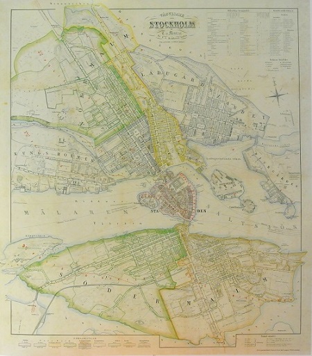
Stockholm - Mentzer ca 1860.
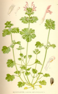
Mjukplister, Lamium Amplexicaule L. - Lindman, C. A. M, Bilder ur Nordens Flora 1917-26.
Olaus Magnus text till den berömda kartan "Carta Marina".
Texten finns även på katalanska, spanska och engelska.
Bureus karta över norden
Kartor och atlaser
Bilder och planschverk
Teckenförklaringar
"Chart-Book öfver Öster-Siön och Katte-Gatt."
Petter Gedda och Werner von Rosenfeldt 1695.
På 1620-talet insåg amiralen Klas Flemming, att den svenska flottan måste ryckas upp, inte bara genom byggandet av nya skepp, utan också genom bättre utbildning av sjöfolket. Inom det svenska amiralitetet hade man under hela 1600-talet varit medveten om att det behövdes en lärobok i navigation och mer tillförlitliga kartor över Östersjön än de holländska som man hittills fått nöja sig med. Men man väntade sig, att någon frivilligt skulle erbjuda sig att både ge ut en dylik lärobok och ta hand om styrmansutbildningen.
1676 erbjöd sig kommendören Werner von Rosenfeldt att ”inrätta styrmanskapet” på ett för kronan gagneligt sätt och den 1 mars 1680 fick han uppdraget att handha styrmännens utbildning, organisera lotsväsendet och ”låta avfatta en nätt sjö cart över hela Öster Sjön”. Rosenfeldt insåg att det fordrades flera blad för detta och till sin hjälp tog han lantmätaren Petter Gedda. Den 17 januari 1687 övertog Gedda Rosenfeldts ämbete under titeln styrmansdirector.
Geddas kartor har inte samma karaktär som våra tiders sjökort. De kan möjligtvis jämföras med översiktskorten. Rosenfeldt och Gedda mätte med kompass och astrolabium, en gradskiva indelad i 360 grader med centralt upphängd diopterlinjal. De användes för att bestämma horisontalvinklarna till de punkter i terrängen, som skulle läggas in på kartan. Mätningarna gjordes med baslinjer, ofta utritade på isen. Det framgår av den precision med vilken djupsiffrorna är systematiskt ordnade, att lodningarna gjordes medan isen låg. Sommaren 1694 reste Gedda och Rosenfeldt med materialet till Amsterdam för att få kartbladen graverade och tryckta. Till sommaren 1695 förelåg så atlasen i en svensk upplaga med titeln ”General-Hydrographisk Chart-Book öfver Öster-Siön och Katte-Gatt” med en introduktion på fyra sidor och 10 kartblad i dubbelfolio 53x59 cm.
Endast två av Geddas atlaser är kända med originalfärgläggning. Ett finns i Göteborgs universitetsbibliotek och det andra på Kungliga Krigsarkivet i Stockholm. Det senare har fått en speciell dedikation till kronprins Karl (XII). Detta exemplar har varit förlaga till en nyutgiven faksimilutgåva i 1.500 ex och särtryck i 500 ex av enskilda blad.
Källa: Professorn vid Krigsarkivet, Ulla Ehrensvärd.
