
1740-1817. Född och död i Paris.
Fransk geograf. Verkade som lärare i geografi och gav bl.a. ut 'Apercu historique et géographique des Quatre Parties du Monde' (1790), 'Des usage de la Sphčre, des globes céleste et terrestre' (1790) och 'Description géographique et historique des peuples les plus renommés de l'Europe ancienne (1809). Under 1790-talet ansvarade han för olika nyutgĺvor av Robert de Vaugondys atlas och gav även ut 'Nouvel Atlas portatif de la Géographie ancienne' (1809) samt 'Atlas élémentaire' som kom i flera utgĺvor.
Bland arbeten.
Apercu historique et géographique des Quatre Parties du Monde.
Des usage de la Sphčre, des globes céleste et terrestre.
Description géographique et historique des peuples les plus renommés de l'Europe ancienne.
Nouvel Atlas portatif de la Géographie ancienne.
Atlas élémentaire.
Nouv. biogr. gen. - Phillips.
1514-1589.
Fransk-nederländsk boktryckare, tryckte i Antwerpen frĺn 1550 bl.a. liturgiska verk och en 'Biblia polyglotta' (8 bd, 1569). P. hade bl.a. en filialofficin i Leiden, som 1586 övertogs av svärsonen F. Raphelengh. P:s efterträdare i ANtwerpen blev hans svärson Jan Moerentorf (Moretus), under vars son, Balthasar Moretus (1574-1641), P. P. Rubens knöts till företaget. - P.-trycken (o. 1600 torde finnas) utmärka sig för vacker utstyrsel och praktiskt format samt stor noggrannhet i tekniken. Tryckeriet ägde bestĺnd i Antwerpen till 1876, dĺ det inköptes av staden och blev Musée Plantin-Moretus.
Christophe Plantin ombesörjde efter 1579 utgivningen av Ortelius atlas 'Theatrum Orbis Terrarum'.
Bland arbeten.
Biblia polyglotta.
Svensk uppslagsbok.
1783-1848. Född i Järpĺs, död i Stockholm.
Svensk kartograf. Utmärkte sig som officer och avancerade till överste. Forsell kom tidigt med i lantmätnings- och kartläggningsarbetet i Sverige och utförde 1804-09 en rad lantmätningsarbeten för det stora Hermelinska kartverket (se denne). 1815-26 gav han ut 'Karta öfver södra delen af Sverige och Norrige' i 9 blad. 1824 blev han överdirektör vid Generallantmäterikontoret. Förutom kartarbeten gav han även ut flera topografiska och statistiska verk. Medlem av Krigsvetenskapsakademien i Sverige och hedersmedlem av Royal Geographical Society i London.
Bland arbeten.
'Karta öfver södra delen af Sverige och Norrige.
Lönborg, s. 204f. - Sv. män och kv.
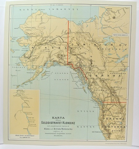
Gulddistriktet Klondike - ca 1897.
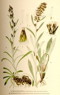
Nordnoppa, Gnaphalium Norvegicum Gunn - Lindman, C. A. M, Bilder ur Nordens Flora 1917-26.
Olaus Magnus text till den berömda kartan "Carta Marina".
Texten finns även pĺ katalanska, spanska och engelska.
Bureus karta över norden
Kartor och atlaser
Bilder och planschverk
Teckenförklaringar
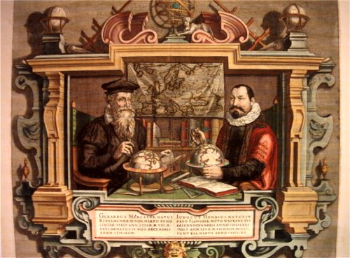
Porträtt pĺ Gerard Mercator och Jodocus Hondius.
"Striking image showing Mercator and Hondius in their idealized workshop.
This famous portrait of two of the most important mapmakers during the Golden Age of Dutch cartography was engraved by Coletta Hondius, as a tribute to her late husband, shortly after his death. Gerard Mercator is shown with his successor, Jodocus Hondius, seated at a table surrounded by the implements of their trade. The fine portrait is set within an elaborate strapwork framework that includes a wall map of Europe.
Gerard Mercator is renowned as the cartographer who created a world map representing new projections of sailing courses of constant bearing as straight lines—an innovation which, to this day, enhances the simplicity and safety of navigation. In his own day, Mercator was the world's most famous geographer. He created a number of wall maps early in his career, as well as one of the earliest modern world Atlases in 1595. Although this was the first appearance of the word Atlas in a geographical context, Mercator used it as a neologism for a treatise on the creation, history and description of the universe, not simply a collection of maps. He chose the word as a commemoration of King Atlas of Mauretania, whom he considered to be the first great geographer.
Jodocus Hondius was a Dutch engraver and cartographer. He is best known for his early maps of the New World and Europe and for continuing publication of Gerard Mercator's World Atlas. He also helped establish Amsterdam as the center of cartography in Europe in the 17th century. In England, Hondius publicized the work of Francis Drake, who had made a circumnavigation of the world in the late 1570s. In 1604, he purchased the plates of Gerard Mercator's Atlas from Mercator's grandson and continued publication of the Atlas, adding his own maps over the next several decades. Hondius later published a pocket version Atlas Minor."
