
Född i Wexford, Irland, död i London.
Engelsk sjöofficer. 1836-47 deltog han i kapten George Backes expedition till Repulse Bay och 1848-49 i James Ross expedition för att undsätta John Franklin som förolyckats under försöket att finna nordvästpassagen. Expeditionen blev misslyckad och 1850 utsändes en ny under ledning av kapten Richard Collinson. McClure fick dĺ kommandot över skeppet 'Investigator'. Skeppen kom ifrĺn varandra och 'Investigator' frös inne vid Melville sund. McClure konstaterade att nordvästpassagen existerade men han lyckades inte att genomföra resan med sitt skepp. Utan att finna spĺr efter kapten Franklin och hans män höll även undsättningsexpeditionen pĺ att fĺ sätta livet till. Först 1854 var den tillbaka i England. Senare tjänstgjorde McClure i Kina och avancerade efter hand till viceamiral.
Salmonsen. - Dict. nat. biogr.
1630-99. Född i Banarps socken, död i Uppsala.
Svensk astronom. Studerade under ĺren 1652-63 i Greifswald och Uppsala och 1664-67 gjorde han en studieresa till en rad av Europas universitetsstäder. 1667 blev han professor i astronomi vid universitetet i Lund och inrättade där det första svenska observatoriet, som kom att ödeläggas under kriget med Danmark 1676-77. 1679 blev han professor i astronomi i Uppsala och inrättade där ett nytt observatorium. Han utgav flera läroböcker i astronomi och under flera ĺr även almanackor. Som astronom var han Erik Dahlbergs (se denne) rĺdgivare vid framställningen av dennes nya karta över Norden.
Lönborg. - Nordenmark.
ca 1705-1765.
A successful publisher in Amsterdam who produced extensive volumes of Dutch town plans as well as a number of atlases with maps usually based on those of G. Delisle.
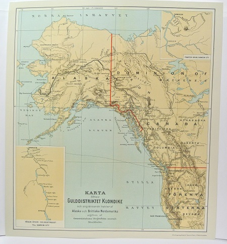
Gulddistriktet Klondike - ca 1897.
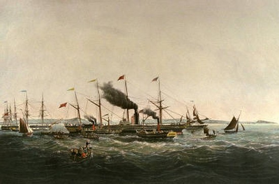
Great Western - Walter, Joseph
Olaus Magnus text till den berömda kartan "Carta Marina".
Texten finns även pĺ katalanska, spanska och engelska.
Bureus karta över norden
Kartor och atlaser
Bilder och planschverk
Teckenförklaringar
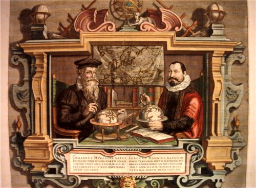
Porträtt pĺ Gerard Mercator och Jodocus Hondius.
"Striking image showing Mercator and Hondius in their idealized workshop.
This famous portrait of two of the most important mapmakers during the Golden Age of Dutch cartography was engraved by Coletta Hondius, as a tribute to her late husband, shortly after his death. Gerard Mercator is shown with his successor, Jodocus Hondius, seated at a table surrounded by the implements of their trade. The fine portrait is set within an elaborate strapwork framework that includes a wall map of Europe.
Gerard Mercator is renowned as the cartographer who created a world map representing new projections of sailing courses of constant bearing as straight lines—an innovation which, to this day, enhances the simplicity and safety of navigation. In his own day, Mercator was the world's most famous geographer. He created a number of wall maps early in his career, as well as one of the earliest modern world Atlases in 1595. Although this was the first appearance of the word Atlas in a geographical context, Mercator used it as a neologism for a treatise on the creation, history and description of the universe, not simply a collection of maps. He chose the word as a commemoration of King Atlas of Mauretania, whom he considered to be the first great geographer.
Jodocus Hondius was a Dutch engraver and cartographer. He is best known for his early maps of the New World and Europe and for continuing publication of Gerard Mercator's World Atlas. He also helped establish Amsterdam as the center of cartography in Europe in the 17th century. In England, Hondius publicized the work of Francis Drake, who had made a circumnavigation of the world in the late 1570s. In 1604, he purchased the plates of Gerard Mercator's Atlas from Mercator's grandson and continued publication of the Atlas, adding his own maps over the next several decades. Hondius later published a pocket version Atlas Minor."
