
Cartographer.
Bland arbeten.
Fluvii Albis (Elbe) nov. delin. 1628, used by Hondius & Blaeu.
Tooley.
1713-1764.
Shipyard commander in Karlskrona 1755.
Sveriges sj÷kartor ľ A. Hedin
CORONELLI, VICENTIUS. [Vincenco Maria]
1650-1718.
Italiensk matematiker och geograf. Han arbetade f÷rst som snickare men gick snart med i en klosterorden, dńr han bedrev flitiga studier inom flera omrňden, och 23 ňr gammal tog han en doktorsgrad. Kort dńrefter blev han ordens 'minister provincialis' i Ungern. 1686 blev han kosmograf f÷r republiken Venedig, senare ocksň professor i geografi vid universitetet i Venedig.
Franciscan monk, was one of the pre-eminent globe makers, his crowning glory being the pair of giant globes he made for Louis XIV, 3,9 metres in diameter.
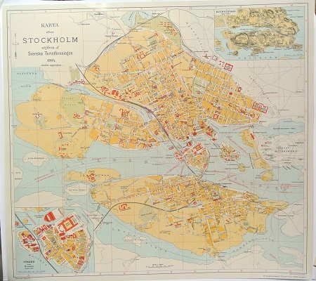
Karta ÷fver Stockholm. - 1904.
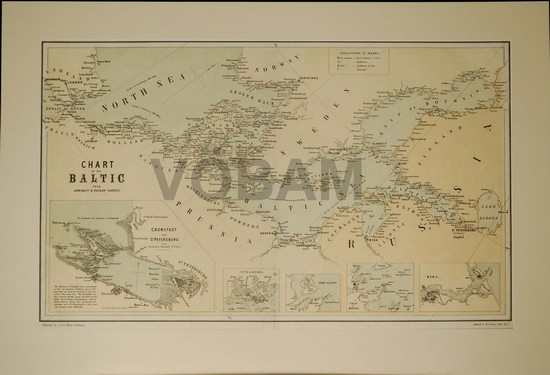
'Chart of the Baltic from Admiralty & Russian Surveys'. - Edinburgh 1857.
F÷rteckning ÷ver kartorna.
vse Baltijskago morya raznykh' sochinenij morsk´ya karty sobrany, razsmotreny, i Rossij-|kimi plavatelyami na istinnye mezhdu mest' kompasnye rumby i distants´i privedeny, | i vymerennymi po prostranstvu morya i u beregov' glubinami, vnov najden-|nymi tam' zhe podvodnymi melyami dopolneny. | A | V' SINUSE FINSKOM' | vse morsk´e berega s' ostrovami, shkherami, rejdami, zalivami, portami i rechnymi ust'yami, | s' glubinami pri nikh, i mezhdu shkher' morya farvaterov' so mnogimi vnov' | naJdennymi melyami, pod' vladen´em' | EYA IMPERATORSKAGO VELICHESTVA | sostoyashsch´e, | PO UKAZU | EYA IMPERATORSKAGO VELICHESTVA | iz' Gosudarstvennoj Admiraltejskoj Kolleg´i Noyabrya II dnya, 1776 [correction with pencil 1746] goda vnov' opisany, vymereny, i v' istinnykh' | polozhen´ya ikh', i mezhdu mest', kompasnykh' rumbakh' i distants´yakh', na morskiya karty, dlya bez-|opasnejshago Rossijskomu flotu plavan´ya postavleny | FLOTA KAPITANOM' PERVAGO RANGA | ALEKSEEM' NAGAEVYM'. Vyrezyvan´em' k' pechati na doskakh' okonchany 1752 goda. Pechatan pri Admiraltejskoj Kolleg´i v' Tipograf´i morskago SHlyahetnago | kadetskogo Korpusa Aprelya ___ dnya 1757 goda.
A. Nagaev och hans sj÷atlas ÷ver Ístersj÷n.
Ryske amiralen Aleksej Nagaev ledde under ňren 1746 - 1752 den ryska Marinakademins sj÷mńtningsexpeditioner i Ístersj÷n. Under denna tid uppmńttes och lodades Ístersj÷n och dess kuster systematiskt och noggrannt av expeditionen. Inte mindre ńn 22 sj÷kort ńr helt nya i Nagaev's atlas. Enbart vissa specialkartor, ÷ver omrňden dit han inte kunde ta sig lńngs svenska och tyska kusterna, ńr kopierade frňn Str÷mcrona's atlas. Íversiktskortet ÷ver Ístersj÷n ńr ńven det kopierat men frňn Gedda-Rosenfeldt's atlas.
Sj÷korten ńr som tidigare nńmnts noggranna i sina djupangivelser, men ńven farleder, grund, prickar, fyrar, ankringsplatser o.s.v. ńr tydligt angivna. Det som skiljer denna sj÷atlas frňn andra ńr att ńven kusterna i mňnga fall ńr karterade. Dńr anges bl.a. h÷jdf÷rhňllanden, markanvńndning, vńgar och bebyggelse.
Det finns en del rena spionkort i Nagaev's atlas och som exempel pň detta ńr kortet ÷ver Íresund, eller ett ńnnu bńttre exempel, kartan ÷ver Helsingfors den ńr mycket noggrannare ńn Str÷mcrona's. Man ska komma ihňg att vid denna tid var fortfarande Helsingfors skńrgňrd en militńr hemlighet av h÷gsta rang.
En del intressanta specialkartor r÷rande Finska viken ńr ńven de vńrda att nńmnas, sňsom kartan ÷ver Gogland och dess omgivande vatten, kartan ÷ver Asp÷ skńrgňrd, inloppet till Tvńrminne m.fl. Dessa visar tydligt de militńra f÷rtecken som kom att bestńmma valet av omrňden f÷r noggrannare kartering f÷rutom de sjńlvklara valen t.ex. Helsingfors skńrgňrd
Kartuscherna i atlasen ńr i mňnga fall enastňende och starkt symboliska med syfte att visa Rysslands makt i Ístersj÷n. Dominium maris Baltici ńr kanske den bństa korta beskrivning man kan ge ÷ver kartuscherna i atlasen.
1757 gavs atlasen ut av St. Petersburgs Marinakademi och kom att bli den bństa sj÷atlasen ÷ver dessa omrňden i 60 ňr till amiral Sarychev's atlas kom ut. I norra Ístersj÷n kom Nagaev's djupsiffror att f÷rbli or÷rda i ÷ver 100 ňr.
Atlas Vsego Baltijskago Morja s Finskim i Botniceskim Zalivami s Skagerakom, Kategatom, Zundom, i Beltami.
Aleksei Ivanovich Nagaev, Russian admiral 1704-1781
Aleksei
Ivanovich Nagaev - admiral, member of the Admiralty College, principal
commander of Kronstadt Port, one of the first Russian scientific hydrographers.
A. I. Nagaev was born in March 1704 in the village of Sertykino, Moscow
Government, and came from an impoverished noble family. At eleven years of age
the boy was taken to Petersburg and sent to the Naval Academy, from whence on
2 March 1721 he was promoted warrant officer. In the following year he
supervised the works at Kronstadt of the digging of the canal, and then on 19
December he was sent to train the naval cadets. This period of teaching lasted
about seven years, by which time he had trained 419 naval cadets. Until
September 1724 he was located with his cadets at Kronstadt, and then he taught
navigation at the Naval Academy until May 1729.
In
March 1729 the Admiralty College decided to send to Arkhangelĺsk two
frigates for practical research under the command of Captain Second Rank D.
Kalmykov. Nagaev was appointed to the frigate ôAmsterdam-Galeiö, on which
he accomplished the voyage to ôKilĺdiuinö and back. Then in 1730 Nagaev
was sent to Astrakhan and ordered to survey the Caspian Sea. For Four years he
worked diligently on the compilation of hydrographic charts of the areas of
the Caspian bordering Astrakhan. At that time on the instructions of
General-in-Chief V. Ia. Levashev he built several flat-bottomed barges for
transporting heavy loads. In 1733 Nagaev was appointed to the special
committee in Astrakhan charged with investigating measures to halt the
widespread destructive effect of the sea winds in Giliani.
Promoted
on 19 March 1731 to lieutenant, Nagaev on 18 January 1733 was gazetted on the
staff with the rank of lieutenant-major, and in 1735 he returned to
Petersburg. Several month later he was ordered to the Smolensk Government
Chancery to investigate outstanding debts due to the Admiralty, and on
returning from there was nominated on 25 November 1737 to the commission
investigating arrears, irregularities and thefts needing reparation in the
provinces. The following year Nagaev was on the commission ôformerly under
the direction of the State Senateö to investigate more quickly income owing
to the Admiralty from the provinces.
In
1739 Nagaev was commissioned to investigate the measurements of the fairway
from St. Petersburg to Vyborg. In the archives of the General Naval
Headquarters is preserved a large volume of some 200 leaves written by Nagaev
himself containing the result of his work in this naval investigation. The
volume is entitled ô24 July 1739 Journal of naval content on boat no. 5 on
the measuring of the fairway from Kronstadt lighthouse to Vyborg under the
command of Lieutenant of the Fleet Aleksei Nagaevö. For these activities
Nagaev in the following year on 3 November was promoted captain with the rank
of colonel.
At
the beginning of 1741 Nagaev was commissioned captain of the frigate
ôCavalierö on which he accomplished the journey from Kronstadt to
Arkangelĺsk. This was one of the most taxing sea voyages. Although the
journey was without accident, in the course of the 57-day voyage, the crew of
the squadron of three frigates lost 121 men from disease, besides carrying
back from Arkangelĺsk 326 sick (the total crew consisted of about 700 men).
In 1742 Nagaev was given command of the frigate ôMercuriusö, and the
following year set off in that ship from Arkangelĺsk to Kronstadt. During
the voyage the frigate struck the island of ôAnautö and sank, and Nagaev
returned on a Danish ship to Petersburg. Brought to trial he alone in 1744 was
acquitted and again was enrolled into the service. Appointed immediately as
adviser to research at the Academy he fulfilled these duties for two years.
In
1741 came the news of the death of Captain-Commodore Bering, and on returning
to Petersburg his colleagues Captain Chirikov and Lieutenant Vaksel presented
to the Admirality College his journals and notes. The College commissioned
Nagaev and Lieutenant Afrosimov to compile charts of the Sea of Kamchatka and
the coast of America, and also to compile maps from the notes of Captain
Shpanberg and Warrant Officer Shelĺg. For a year Nagaev compiled detailed
charts of the Kamchatka Sea and mouth of the Amur, which were the first, and
for a long time the only maps of that region.
In
1746 he was given command of the ship ôFridemakerö (Peacemaker). Besides
this in May 1746 Captain Malygin, commander of the navigation company, gave a
report in which all the compasses made for the Admiralty had quite striking
differences and errors in declination. On receiving from the Admiralty College
instructions to look into the matter, Nagaev ascertained the veracity of
Malyginĺs statement and proposed the elimination of the errors:
1.
To make pointers from the best steel instead of two wires.
2.
For the regulation of compasses to pass at Kronstadt Port a meridian line,
without which it was practically impossible to check the veracity of the
compass reading.
These
proposals were accepted by the College, and the laying of the meridian line
was supervised by Nagaev himself.
Nagaev
completed this task and sailed in 1746 round the Baltic Sea on the ôFridemakerö.
Early in October that year he returned to Petersburg and was appointed to
research for the Academy. On 11 November 1746 Nagaev was instructed by the
Admiralty College with ôeffecting naval charts with the greatest accuracyö.
In December that year Nagaev presented to the College in this connection a
detailed report on everything that was necessary in his view for the speedy
completion of the task entrusted to him. The College sanctioned everyting he
proposed, and early in 1747 he started his task. The results of this task
appeared in an atlas of maps of various parts of the Baltic Sea. Each map was
presented to The College and was inspected by members independently, and in
1752 they were all engraved. All the maps were well executed and thoroughly
accurate as they contained not only the results of Nagaevĺs material,
collected by Russian sailors, but also material from Swedish charts.
Enrolled
on 5 September 1751 as Captain Second Rank Nagaev the following year took an
active role in education at the Naval Sailing Corps. Promoted on 15 March 1757
to Captain First Rank, Nagaev was then commissioned as Director of the Naval
Sailing Corps and member of the commission of building at Rogervik. In 1756
Nagaev was charged with compiling new signals for the fleet, and in April the
following year he presented to the College his work which was printed in the
press of the Naval Corps. The atlas, published in 1757, served as a guide to
sailing the Baltic and German Seas for sixty years, until the publication of
the atlas of the Baltic Sea by Admiral Sarychev. Several of the depths in the
northern part of the Baltic Sea from the Island of Ezelĺ and Gotland north
to the Aland skerries remained in Russian as well as in foreign charts taken
from Nagaevĺs atlas for more than 100 years.
On
5 May 1757 Nagaev was promoted to Captain Commodore. Relieved of his duties as
director of the Naval Sailing Corps in 1761, Nagaev was appointed a member of
the commission for putting the fleet in good order on 16 February the
following year. On 10 April he was promoted to Rear Admiral. On the accession
to the throne of Empress Catherine II, Nagaev sailed from Kronstadt to Pilau
with a squadron of three ships for delivery of the sick from the Russian army
marching into Prussia. Returning at the end of September to Petersburg Nagaev
attended meetings in the Admiralty College, and in October was appointed
member of the Kolberg Commission.
At
the beginning of the following year he was commissioned to compile
instructions for Lieutenants Bulgakov, Bukovskij and Laptev, who had been
ordered to produce a description of Lake Ladoga. In the same year during the
whole of the summer sailings he executed the duties of quartermaster on Her
Majestyĺs sloop at the time of Empress Catherine IIĺs progresses up the
Neva. Early in 1764 Nagaev together with Count I. G. Chernyshev drew up a plan
for two expeditions which were preparing to investigate the Northern Arctic
Ocean. Promoted on 4 May 1764 to Vice-Admiral Nagaev was then appointed as
principal commander of Kronstadt port. Not long before this, Nagaevĺs house
was damaged in a serious fire and some of his charts and manuscripts were
destroyed.
In
his duties as principal commander of Kronstadt port Nagaev served about two
years. Awarded in 1765, the Order of St. Anne, he was relieved of his duties
as principal commander and in December appointed member of the Admiralty
College. Returning to Petersburg at the beginning of 1766 Nagaev together with
Lieutenant-Captain D. Selianinov worked hard on the compilation of Lake
Ladoga.
On
3 January 1767 Nagaev was commissioned by the Admiralty College to compile
instructions for the expedition preparing to describe the White Sea. However
he was soon forced to go to Moscow, when he was chosen on 22 January as deputy
from Vasilĺevskii Island and from the Admiraly College to serve on the
commission investigating a new code of laws. He remained in Moscow for about a
year serving on the commission, and on 14 December was ordered by Empress
Catherine II also to appear at the commission in Petersburg. Nagaev did not
appear to play a particularly active role in work on the new law code. More
often than not he tened to agree with the opinions of the other deputies. In
addition to attending the meetings of the Great Assembly, Nagaev also became a
member of the subcommittee on caution of contradiction between military and
civil laws.
While
still in Moscow and besides the work for the committee and subcommittee, he
described together with Navigator S. Zakharov the River Moscow. Then having
received from Navigators Pososhkov and Trubnikov a description of the River
Oka from its source to its confluence with the Moscow River, he compiled from
them maps of that river, which were collected in a separate atlas. Returning
to Petersburg in January 1768 he as before attended the Admiralty College and
soon after received instructions to prepare a fairway, which would be needed
to carry the stone to be used in the monument to Peter I.
Promoted
on 4 July 1769 to Admiral, Nagaev fulfilled his duties as an elder member of
the Admiralty College for some time. In due course he was ordered to Reval to
supervise the repair of damaged frigates from Spiridovĺs squadron which had
been forced by accidents to put in at Reval. Nagaev also supervised all the
new buildings of the Naval Department at Reval. Returning to Petersburg Nagaev
again occupied himself with hydrographic work.
In
January 1779 the governor of Siberia D. I. Chicerin sent to the Admiralty
College Foreman Lobashkov, who had described the shores and mouth of the River
Kolyma and Bear Island. Nagaev was appointed to compile maps from the details
in these notes, which he presented to the Empress Catherine II.
About
this time Lieutenant Captain Levashev returned from the expedition to
Kamchatka, he was a companion of Captain Krenitsyn, who had drowned in the
River Kamchatka. Levashev handed over to the College all the plans, notes and
measurements made by Krenitsyn and also his own. The College gave this
material for editing by Nagaev, who was instructed to compile from them a
general map of the route of the expedition, which he quickly fulfilled. From
April 1773 to the end of the following year Nagaev governed the Admiralty
College during the absence of Vice-President Count Chernyshev, who had been
granted 18-monthsĺ leave. At that time Nagaevĺs deteriorating health
forced him to leave the College, and to soon request his retirement. On 10
July 1775 he was retired on account of ill health with a pension based on his
last yearĺs service and awarded the Order of St. Alexander Nevskii. However
despite the state of his health Nagaev did not cease to work on the correction
and compilation of naval charts and draughts.
In
1789-90 Nagaevĺs ôSailing Directions of the Sea Voyage, containing
Descriptions of the fairways and entrances to ports found in the gulf of
Finland, the Baltic Sea, the Sound and in the Skagerrakö was published in 3
volumes by the Press of the Naval Cadet College at St. Petersburg.
ôIn
his homeö, wrote his biographer Pagaev-Verevkin, better known as an admiral,
ôthere was no room but for papers, books and maps he was studying. Only when
he slept did he not have a slate-pencil, pen or crayon in his handsö.
Nagaev
died in Petersburg on 8 January 1781. After that, besides numerous maps and
plans remained many papers among which he had hoped to prepare for publication
both the voyages of Bering and the naval journals of Captains Chichagov and
Krenitsyn. He had also collected materials for the biographies of Russian
sailors, and the letters of Peter the Great. These latter served as a basis
for the work of V. N. Berkh under the title ôCollection of Letters of
Emperor Peter I to various Individuals, with their repliesö. (Russian
Biographical Dictionary, St. Petersburg, Imperial Russian Historical Society,
1914.)
Bagrow,
A History of Russian Cartography up to 1800, pp. 221 ff.
