
1744-1820. Född och död i Stockholm.
Svensk kartograf och friherre. 1770 blev han bergsmästare och 1781 bergsrĺd. Han gjorde även en förtjänstfull insats som kartograf genom att ta upp en gammal plan om geografisk beskrivning och kartläggning av Sverige och Finland. Verket pĺbörjades 1795 och avslutades 1818 med totalt 33 kartor med titeln 'Geographiske chartor öfver Swerige i 4 afdelingar'. Det 'Hermelinska kartverket', som är den första svenska rikskartan i atlasform, fick stort erkännande. Arbetet med kartorna försatte honom i svĺra ekonomiska omständigheter. Hermelin var medlem av en rad lärda sällskap bĺde i Sverige och utomlands.
Bland arbeten.
Kartor i verket Geographiske chartor.
Finland.
1. Storfurstendömet Finland.
2. Nylands och Tavastehus samt Kymmene-gĺrds höfdingedömen.
3. Savolax och Karelens eller Kuopio höfdingedömen.
4. Uleĺborgs höfdingedöme.
5. Wasa höfdingedöme.
6. Ĺbo och Björnebergs höfdingedöme med Ĺland.
Sverige.
1. Swerige med tillgränsande länder.
2. Carlstads höfdingedöme eller Wärmeland. (2 blad).
3. Elfsborgs höfdingedöme.
4. Göta rike eller Södra delen af Sverige.
5. Göteborgs och Bohusläns höfdingedöme.
6. Halmstads höfdingedöme eller Halland.
7. Helsingland och Gestrikland.
8. Herjeĺdalaen.
9. Jönköpings, Kronobergs och Blekings höfdingedömen.
10. Kalmar höfdingedöme med Öland.
11. Kopparbergs Säters, Näsgĺrds och Wester bergslags fögderier i St. Kopparbergs höfd.
12. Linköpings höfdingedöme eller Östergötland.
13. Nyköpings höfdingedöme.
14. Skaraborgs höfdingedöme.
15. Skĺne eller Malmöhus och Christianstads höfdingedömen. (2 blad).
16. Stockholms höfdingedöme.
17. Stora Kopparbergs höfdingedöme eller Dalarne.
18. Svea rike och Norrland.
19. Upsala höfdingedöme.
20. Westerbotten och Lappmarken, eller Umeĺ höfdingedöme.
21. Westerĺs höfdingedöme.
22. Wisby höfdingedöme eller Gottland.
23. Ĺngermanland, Medelpad och Jämtland eller Wester Norrlands höfdingedöme.
24. Örebro höfdingedöme.
I atlasen ingĺr även 3 vyer / utsikter.
1. Utsigt af ett Wattenfall i Lappmarken.
2. Utsigt af en Belägenhet i Finland.
3. Utsigt af Stockholm.
Totalt 33 kopparstick.
(Lönborg, s. 193-209. - Sv. män och kv.
1767-1848.
Thackara was eight months old when he and his parents came to Philadelphia from England. He apprenticed with Robert Scott and James Trenchard as an engraver from 1786 to 1789. In 1790 he married James Trenchard's sister Hannah. Thackara was curator for the Pennsylvania Academy of Fine Arts from 1816 to 1828, and he is listed as an engraver in the Philadelphia City Directories from 1791 to 1833. His partnership with John Vallance is listed in the 1794 City Directory. He and his son William formed the firm of Thackara and Son in 1832. Thackara was elected Commissioner of the District of Southwark Philadelphia in 1797, and served as clerk of the Pennsylvania House of Representatives from 1807 to 1810.
Washington Map Society.
Född 1732 15/1 i Valsberga, Ĺkers sn (Söd.), död 1797 4/11 pĺ Brĺtorp i ovann. sn.
Kommissionslantmätare. Kartgravör. Son av kronolänsmannen Olof Ĺ. och Maria Ekström. Student vid Uppsala universitet 1754. Blev sedan enligt egen utsago »informator hos löjtnant Ridderhjerta, dels ock vid Kungsör hos slottsinspektoren Jesper Petrseus att informera dess dotterson Jesper Gillberg, hvarmed fortsattes till 1756. Ĺr 1757 antog jag station hos akademigravören Ĺkerman, hvilken jag hjälpte med gravyr af bokstäfver, sĺ att jag fanns skicklig gravera alla namn, som stĺ pĺ den första här i riket utgifna jordgloben med en fots diameter, fast jag ej fick hedern att mitt namn sattes pĺ globen» (EKSTRAND). Kommissionslantmätare 1781. Ägde Brĺtorp.
Bland arbeten.
A. BERCH, Oeconomisk beskrifning öfver Wadsbo härad uti Westergöthland och Skaraborgs höfdingedöme, diss., resp. G. F. Bergman, Uppsala 1759: karta över Vadsbo härad.
Karta över Tveta härad i Smĺland. 17601.
Stockholms magazin, 1780: striden vid Brunnbäck jämte karta över Grytnäs och Folkärna socknar, efter G. Halstenson 1652.
Svenskarna under Wilhelm Carpelan förstöra den preussiska flottiljen i Frisches Haff 1759, efter C. Rutensparre, kpst.
Hultmark, 1944.
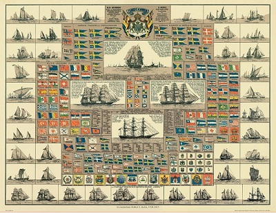
Amiral Häggs flaggkarta. - Stockholm 1888.
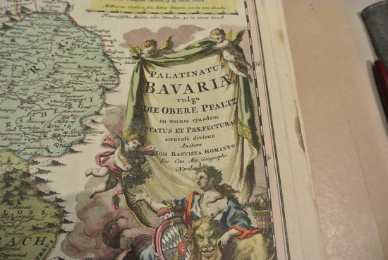
Palatinatus Bavariae, - J. B. Homann ca 1720.
Olaus Magnus text till den berömda kartan "Carta Marina".
Texten finns även pĺ katalanska, spanska och engelska.
Bureus karta över norden
Kartor och atlaser
Bilder och planschverk
Teckenförklaringar
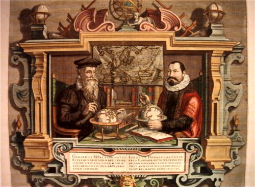
Porträtt pĺ Gerard Mercator och Jodocus Hondius.
"Striking image showing Mercator and Hondius in their idealized workshop.
This famous portrait of two of the most important mapmakers during the Golden Age of Dutch cartography was engraved by Coletta Hondius, as a tribute to her late husband, shortly after his death. Gerard Mercator is shown with his successor, Jodocus Hondius, seated at a table surrounded by the implements of their trade. The fine portrait is set within an elaborate strapwork framework that includes a wall map of Europe.
Gerard Mercator is renowned as the cartographer who created a world map representing new projections of sailing courses of constant bearing as straight lines—an innovation which, to this day, enhances the simplicity and safety of navigation. In his own day, Mercator was the world's most famous geographer. He created a number of wall maps early in his career, as well as one of the earliest modern world Atlases in 1595. Although this was the first appearance of the word Atlas in a geographical context, Mercator used it as a neologism for a treatise on the creation, history and description of the universe, not simply a collection of maps. He chose the word as a commemoration of King Atlas of Mauretania, whom he considered to be the first great geographer.
Jodocus Hondius was a Dutch engraver and cartographer. He is best known for his early maps of the New World and Europe and for continuing publication of Gerard Mercator's World Atlas. He also helped establish Amsterdam as the center of cartography in Europe in the 17th century. In England, Hondius publicized the work of Francis Drake, who had made a circumnavigation of the world in the late 1570s. In 1604, he purchased the plates of Gerard Mercator's Atlas from Mercator's grandson and continued publication of the Atlas, adding his own maps over the next several decades. Hondius later published a pocket version Atlas Minor."
