
1804-1837.
Storskifteslantmätare, verksam i Dalarna.
Bland arbeten.
Charta öfver Aspeboda socken uti Stora Kopparbergs län [Kartografiskt material] / afmätt åren 1806, 1807 & 1808 af dertill förordnade landtm:re ; transporterad och copierad år 1831 af A.G. Théel
Charta öfver Thorsångs socken i Stora Kopparbergs län [Kartografiskt material] / ifrån en af landtm. C.P. Nyrén uppgord charta transporterad... af A.G. Théel
Jerna socken uti Stora Kopparbergs län och Wäster Dahlarne [Kartografiskt material] / ifrån storskifteskartan transporterad af A.G. Théel
Leksands socken uti Nedan Siljans fögderi af Stora Kopparbergs län [Kartografiskt material] / ifrån storskiftes mätningarne transporterad af A.G. T[hée]l
Äppelbo socken uti Stora Kopparbergs län och Wäster Dahlarne [Kartografiskt material] / ifrån storskiftes chartan transporterad... af A.G. Théel
Engelsk kartritare vid mitten av 1800-talet. Enligt hans egna upplysningar på kartorna var han medlem av Royal Geographical Society. Inga övriga upplysningar hittade.
1785-1869. Född i Hurum, död i Drammen.
Norsk ämbetsman. Tog juridisk examen 1807, blev sockenskrivare i Nordre Jarlsberg 1810, byfogde och byskrivare i Drammen 1826, länsman i Buskerud 1831-57. Stortingsman under en rad år och medlem av flera offentliga kommissioner, däribland 'Hovedmatrikuleringskommisjonen' 1823-38. Han författade en rad ekonomiska och statistiska skrifter. Av dessa kan nämnas 'Das Königreich Norwegen statistisch beschrieben' från 1843. Medlem av Vetenskapssällskapet i Trondheim.
Bland arbeten.
Das Königreich Norwegen statistisch beschrieben.
K. St. O.O. Halvorsen.
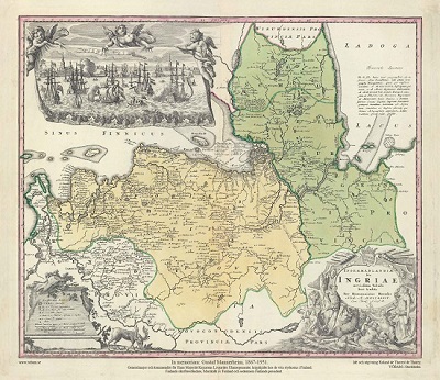
Ingermanlandiae – Homanns Erben 1734
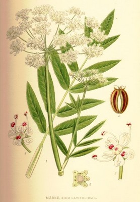
Märke, Sium latifolium - Lindman, C. A. M, Bilder ur Nordens Flora 1917-26.
