
GERRITSZ [GERARD, GERARDUS, GHERRITSZOON van ASSUM].
Hessel 1581-1632.
Gerritsz was apprenticed to W. J. Blaeu as an engraver before starting in business on his own account. He worked closely with Petrus Plancius and his merit may be judged by the fact that he was appointed Cartographer to the Dutch East India Company in preference to Blaeu and subsequently held the same position in a newly formed West India Company. With the new company he came into touch with Johannes de
Laet for whom he prepared a number of new maps of America in the latter's Nieuwe Wereldt published in 1625. His most important early work was a chart showing Henry Hudson's discoveries in his voyage of 1610-11: it is the first to give an outline of Hudson's Bay and indicates Hudson's belief that he had found a way to the North West Passage.
Engraver, cartographer, publisher and bookseller, b. Assum, apprenticed as engraver to Blaeu, Cartographer to Dutch E. India Co. 1617, fl. 1607; from 1612 using sign 'in de Paskaert' or 'sub signo Tabulae Nauticae'. Addresses: (1) opt Water bij die oude Brug [1609...
Tooley.
Den som mńtte upp omrňdet kring Nyen var emellertid en inf÷dd svensk: Erich Nilsson Aspegreen. Han var en lantmńtare som f÷rst lejts privat av Gustav II Adolfs halvbror Carl Carlsson Gyllenhielm. Denne hade pň 1620-talet utnńmnts till det svenska rikets f÷rste stňthňllare i Ingermanland. Nńr det blev aktuellt med staden Nyens utvidgning, skedde detta bl.a. genom intrňng pň Gyllenhielms domńner.
Kart & Bildteknik 2003:3, artikel "Frňn Nyen till Hiddensee. Svensk kartlńggning under 1600-talet". Av Ulla Ehrensvńrd.
1572-ca. 1632.
Hollńndsk kartograf. Gjorde sig frńmst ber÷md f÷r konstruktionen av en ny typ av sj÷kort. Han hńvdade att den vanliga plana formen gav en felaktig framstńllning av kartbilden och f÷rs÷kte istńllet 'gebulte kaarten' sň att den f÷ljde jordens buktning. De f÷rsta kartorna av denna typ kom ut under ňren 1595-98. De blev mycket omstridda och var knappast lńnge i bruk. Han samarbetade senare med Jodocus Hondius d.y. (se denne). ┼r 1613 gav de f÷rutom en Nordenkarta, ńven ut en himmelsglob.
Nederl. biogr., II. - Orbis., s. XV.
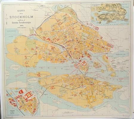
Karta ÷fver Stockholm. - 1904.
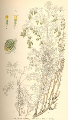
Strandmal÷rt, Artemisia Maritima L - Lindman, C. A. M, Bilder ur Nordens Flora 1917-26.
JACOBSZ, THEUNIS (eller ANTHEUNIS).
Biografiska uppgifter:Ca. 1607-50. F÷dd och d÷d i Amsterdam.
c. 1606-50
JACOB JACOB5Z (LOOTSMAN) (son) d. 1679
Hollńndsk kartograf. Han var boktryckare och bokhandlare. 1648 gav han ut 't'Nieuw groot Straets-boeck, inhoudende d'Middelantse Zee'. Efter sin d÷d gav sonen Jacob Theunisz (se denne) ut 't'Nieuwe en vergroote Zeeboeck, dat is des Piloots ofte Lootsmans Zee-Spiegel, inhoud de Zee-kusten vande Noordsche, Oosterzee ende Westersche Schipvaert' (1653). Bňda dessa atlaser kom senare i flera utgňvor.
Anthonie Jacobsz founded a printing and publishing business in Amsterdam in which he specialized in the production of pilot books and sea atlases. As he died at a comparatively early age most of the numerous editions of his works appeared after his death published by his sons, Jacob and Caspar, who took the name 'Lootsman' (sea pilot) to distinguish them from another printer of the name Jacobsz.
Following Blaeu and Colom, Anthonie Jacobsz was the most important compiler of sea charts in Amsterdam in the first half of the seventeenth century. In his new ZeeSpiegel issued in 1643 he increased the number of charts normally included in these books and enlarged them to folio size, which evidently proved popular. Editions in many forms appeared until 1715 and they were copied or reprinted by Pieter Goos, Hendrick Doncker and Jan Jansson, sometimes in competition with each other but usually in cooperation with the Lootsman brothers.
Bland arbeten:
t'Nieuw groot Straets-boeck, inhoudende d'Middelantse Zee.
t'Nieuwe en vergroote Zeeboeck, dat is des Piloots ofte Lootsmans Zee-Spiegel, inhoud de Zee-kusten vande Noordsche, Oosterzee ende Westersche Schipvaert.
(Kleerkooper. - Phillips.)
