
1600-1684.
One of Sweden's first surveyors. Worked in the provinces of Östergötland and Värmland.
Jean de Rogier (1600-84) var en produktiv och skicklig lantmätare. Han föddes i Frankrike men var frĺn l630-talet verksam som lantmätare, huvudsakligen i Östergötland. Under perioden 1636-50 utgav han geometriska kartor över Norrköpings stad,bergslagen Vĺnga, Hällestad, Tjällmo och Godegĺrd samt häraderna Östkind, Brĺbo, Björkekind, Memming och Hammarkind.
Rogier fortsatte sedan med en geografisk kartläggning av landskapet. Fyra delar i skala ca 1:50 000 utgavs:
Östanstĺng, landskapet mellan Stĺngĺn, Motala ström, Östersjön och Smĺland (1653).
Västanstĺng, Östgötaslätten väster om Stĺngĺn (1657). Originalet finns i Stifts- och landsbiblioteket i Linköping. En andra upplaga utkom 1660.
Ydre och Kinda härader (1660), omfattar även de sydligaste delarna av Hanekinds, Valkebo, Vifolka och Göstrings härader. (Ydre och Kinda härader hade sĺ sent som 1645 införlivats med Östergötlands län.)
Bergslagen, dv...
Sveriges sjökartor – A. Hedin.
Bland arbeten.
Encyclopédie ou dictionnaire universel raisonné des connaissances humaines.
1744-1820. Född och död i Stockholm.
Svensk kartograf och friherre. 1770 blev han bergsmästare och 1781 bergsrĺd. Han gjorde även en förtjänstfull insats som kartograf genom att ta upp en gammal plan om geografisk beskrivning och kartläggning av Sverige och Finland. Verket pĺbörjades 1795 och avslutades 1818 med totalt 33 kartor med titeln 'Geographiske chartor öfver Swerige i 4 afdelingar'. Det 'Hermelinska kartverket', som är den första svenska rikskartan i atlasform, fick stort erkännande. Arbetet med kartorna försatte honom i svĺra ekonomiska omständigheter. Hermelin var medlem av en rad lärda sällskap bĺde i Sverige och utomlands.
Bland arbeten.
Kartor i verket Geographiske chartor.
Finland.
1. Storfurstendömet Finland.
2. Nylands och Tavastehus samt Kymmene-gĺrds höfdingedömen.
3. Savolax och Karelens eller Kuopio höfdingedömen.
4. Uleĺborgs höfdingedöme.
5. Wasa höfdingedöme.
6. Ĺbo och Björnebergs höfdingedöme med Ĺland.
Sverige.
1. Swerige med tillgränsande länder.
2. Carlstads höfdingedöme eller Wärmeland. (2 blad).
3. Elfsborgs höfdingedöme.
4. Göta rike eller Södra delen af Sverige.
5. Göteborgs och Bohusläns höfdingedöme.
6. Halmstads höfdingedöme eller Halland.
7. Helsingland och Gestrikland.
8. Herjeĺdalaen.
9. Jönköpings, Kronobergs och Blekings höfdingedömen.
10. Kalmar höfdingedöme med Öland.
11. Kopparbergs Säters, Näsgĺrds och Wester bergslags fögderier i St. Kopparbergs höfd.
12. Linköpings höfdingedöme eller Östergötland.
13. Nyköpings höfdingedöme.
14. Skaraborgs höfdingedöme.
15. Skĺne eller Malmöhus och Christianstads höfdingedömen. (2 blad).
16. Stockholms höfdingedöme.
17. Stora Kopparbergs höfdingedöme eller Dalarne.
18. Svea rike och Norrland.
19. Upsala höfdingedöme.
20. Westerbotten och Lappmarken, eller Umeĺ höfdingedöme.
21. Westerĺs höfdingedöme.
22. Wisby höfdingedöme eller Gottland.
23. Ĺngermanland, Medelpad och Jämtland eller Wester Norrlands höfdingedöme.
24. Örebro höfdingedöme.
I atlasen ingĺr även 3 vyer / utsikter.
1. Utsigt af ett Wattenfall i Lappmarken.
2. Utsigt af en Belägenhet i Finland.
3. Utsigt af Stockholm.
Totalt 33 kopparstick.
(Lönborg, s. 193-209. - Sv. män och kv.
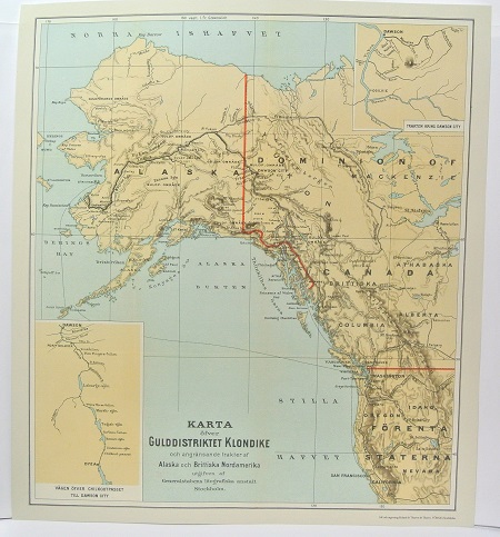
Gulddistriktet Klondike - ca 1897.
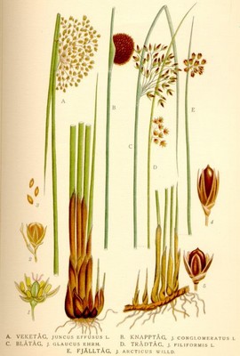
Blĺtĺg, Juncus glaucus - Lindman, C. A. M, Bilder ur Nordens Flora 1917-26.
