
Född 1721 19/5 i Halla sn (Söd.), död 1778 3/2 i Uppsala (Hel. Tref. förs.).
Tecknare, kopparstickare, etsare, kartgravör och globfabrikör. Son av snickaren och svarvaren Olof Andersson och Ingeborg Simonsdotter. Lärde sig gravera för Carl Erik Bergquist i Stockholm i början av 1740-talet. Student vid Uppsala universitet 1747. Utnämndes 1758 till gravör vid Vetenskapssocieteten i Uppsala och uppfördes följ. ĺr pĺ akademistaten. Medlem av det första svenska geografiska sällskapet 'Kosmografiska sällskapet' 1758. Var sällskapets gravör. Grundade 1759 en verkstad för tillverkning av glober i Uppsala. De minsta globerna var sĺ smĺ att de kunde användas som 'fickglober'. 'Himmelsgloben' bestod av ett sfäriskt skal som var itudelat för att användas som fodral runt jordgloben. Dĺ staden 1766 30/4 härjades av en förödande eldsvĺda, förlorade Ĺ. »60 par glob-klot». Efter Ĺkermans död övertogs rörelsen av Fredrik Akrel, som 1779 flyttade verkstaden till Stockholm. — Utgav Atlas juvenilis, Uppsala 1768, med 20 kolor. kartor; 2:a uppl. utkom 1774 och innehöll 30 kolor. kartblad, samtl. graverade ...
Bland arbeten.
{M. STRÖMER], Läran om klotet och spheriska trigonometrien, Sthlm 1759: 9 tab. med geometriska figurer, etsn.
Den swenska Mercurius, 1758: karta över tyska kriget, 1758.
N. BIELKE, Rese-charta öfwer Södermanlands höfdingedöme, 1765.
Hydrografisk karta över Finska viken, 1768, 2 blad.
Hultmark, 1944 m.fl.
1767-1848.
Thackara was eight months old when he and his parents came to Philadelphia from England. He apprenticed with Robert Scott and James Trenchard as an engraver from 1786 to 1789. In 1790 he married James Trenchard's sister Hannah. Thackara was curator for the Pennsylvania Academy of Fine Arts from 1816 to 1828, and he is listed as an engraver in the Philadelphia City Directories from 1791 to 1833. His partnership with John Vallance is listed in the 1794 City Directory. He and his son William formed the firm of Thackara and Son in 1832. Thackara was elected Commissioner of the District of Southwark Philadelphia in 1797, and served as clerk of the Pennsylvania House of Representatives from 1807 to 1810.
Washington Map Society.
Svensk adlig ätt, som härstammar frĺn Jakob Hagman (se NORDENCREUTZ, JAKOB) och Filip Schultz (se NORDENCREUTZ, FILIP), hvilka 1719 samtidigt adlades med namnet N. och 1720 introducerades pĺ samma nummer. Den förre slöt själf sin ätt.
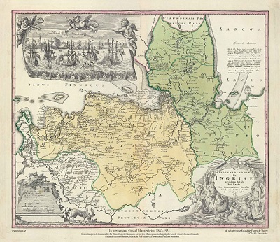
Ingermanlandiae – Homanns Erben 1734
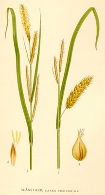
Blĺsstarr, Carex vesicaria - Lindman, C. A. M, Bilder ur Nordens Flora 1917-26.
Keere, Pieter van den [Kaerius, Petrus]
Biografiska uppgifter:1571-c. 1646.
Pieter van den Keere was one of a number of refugees who fled from religious persecution in the Low Countries between the years 1570 and 1 590. He moved to London in 1584 with his sister who married Jodocus Hondius, also a refugee there, and through Hondius he undoubtedly learned his skills as an engraver and cartographer. In the course of a long working life he engraved a large number of individual maps for prominent cartographers of the day but he also produced an Atlas of the Netherlands (1617-22) and county maps of the British Isles which have become known as Miniature Speeds, a misnomer which calls for some explanation.
In about 1599 he engraved plates for 44 maps of the English and Welsh counties, the regions of Scotland and the Irish provinces. The English maps were based on Saxton, the Scottish on Ortelius and the Irish on the famous map by Boazio. These maps were not published at once in book form but there is evidence which suggests a date of issue (in Amsterdam) between 1605 and 1610 although at least one authority believes they existed only in proof form until 1617 when Willem Blaeu issued them with a Latin edition of Camden's Britannia. At this stage two maps were added, one of the British Isles and the other of Yorkshire, the latter derived from Saxton. To confuse things further the title page of this edition is signed 'Guilielmus noster Janssonius', which is the Latinized form of Blaeu's name commonly used up to 1619.
At some time after this the plates came into the possession of Speed's publishers, George Humble, who in 1627, the year in which he published a major edition of Speed's Atlas, also issued the Keere maps as a pocket edition. For these he used the descriptive texts of the larger Speed maps and thereafter they were known as Miniature Speeds. In fact, of the 63 maps in the Atlas, 40 were from the original van den Keere plates, reworked, 16 were reduced from Speed and 7 were additional. The publication was very popular and there were further re-issues up to 1676.
