
Beskriven som 'Navigator and Hydrograph in Dieppe' (1634). Utgav bl.a. en hydrografisk världskarta.
RdeT.
FLEURIEU, CHARLES-PIERRE CLARET de.
1738-1810.
Greve, fransk sjöofficer. Född i Lyon, död i Paris. Som ung kom han in i marinen, blev kapten 1776 och samma ĺr hamn- och arsenaldirektör. Under krigen 1778-83 visade han sig som en mycket duktig strateg. 1790-91 var han marin- och koloniminister. Vid revolutionen fängslades han men släpptes fri och hade senare olika offentliga ställningar bĺde under republiken och kejsardömet. 1808 blev han greve. Han gav ut flera geografiska verk, varav kan nämnas 'Découvertes des Francais en 1768 et 1769 dans le sud-est de la Nouvelle-Guinée' (1790) och 'Voyage d'un autour du monde par Etienne Marchand' (1798). 1809 kom en stor atlas över skandinaviska farvatten. 'Neptune des mers du Nord, ou Atlas du Cattégat et de la Baltique'.
Bland arbeten.
Découvertes des Francais en 1768 et 1769 dans le sud-est de la Nouvelle-Guinée.
Voyage d'un autour du monde par Etienne Marchand.
Neptune des mers du Nord, ou Atlas du Cattégat et de la Baltique.
Nouv. biogr. gen.
1812-87.
Engelsk geograf. Han var son till James Wyld (se denne). Fick först militär träning men gick snart över till faderns verksamhet. Han köpte William Fadens (se denne) kartförlag och blev 1830 medlem av Royal Geographical Society. Hans företag blev med tiden mycket omfattande och 1854 fanns den pĺ tre olika ställen i London. Som kartutgivare ansträngde han sig alltid för att tillgodose det aktuella behovet. I hans produktion finner man sĺledes specialkartor över guldgrävardistrikt, krigskartor osv. Hans 'Popular Atlas' fick stor utbredning. Wylds kartor kom ofta kompletterade med värdefulla geografiska upplysningar. Hans största verk som geograf var emellertid en väldigt väl genomarbetad jordglob, som han slutförde 1851. Den var 60 fot hög, 40 fot i diameter och upplyst med gas. Wyld hade titeln kunglig geograf.
Bland arbeten.
Popular Atlas.
Dict. nat. biogr.
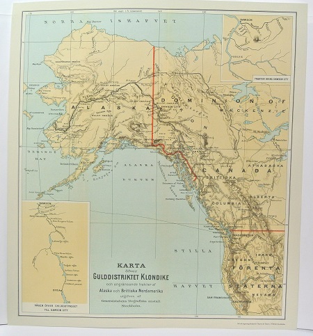
Gulddistriktet Klondike - ca 1897.
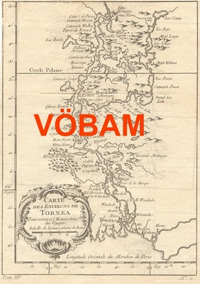
'Carte des Environs de Tornea' - 1740-talet.
Cassini de Thury, César-François
Biografiska uppgifter:17 June 1714 – 4 September 1784
César-François Cassini de Thury (17 June 1714 – 4 September 1784), also called Cassini III or Cassini de Thury, was a French astronomer and cartographer.
Cassini de Thury was born in Thury-sous-Clermont (Oise), the second son of Jacques Cassini and Suzanne Françoise Charpentier de Charmois. He was a grandson of Giovanni Domenico Cassini, and would become the father of Jean-Dominique Cassini, Comte de Cassini.
In 1735, he became a member of the French Academy of Sciences as a supernumerary adjunct astronomer, in 1741 as an adjunct astronomer, and in 1745 as a full member astronomer.
In January, 1751 he was elected a Fellow of the Royal Society.
He succeeded to his father’s official position in 1756 and continued the hereditary surveying operations. In 1744, he began the construction of a great topographical map of France, one of the landmarks in the history of cartography. Completed by his son Jean-Dominique, Cassini IV and published by the Académie des Sciences from 1744 to 1793, its 180 plates are known as the Cassini map(fr).
The post of director of the Paris observatory was created for his benefit in 1771 when the establishment ceased to be a dependency of the French Academy of Sciences.
His chief works are: La méridienne de l’Observatoire Royal de Paris (1744), a correction of the Paris meridian; Description géométrique de la terre (1775); and Description géométrique de la France (1784), which was completed by his son ('Cassini IV').
César-François Cassini de Thury died of smallpox in Paris on 4 September 1784,
The Cassini projection is a map projection described by César-François Cassini de Thury in 1745. It is the transverse aspect of theequirectangular projection, in that the globe is first rotated so the central meridian becomes the 'equator', and then the normal equirectangular projection is applied.
In practice, the projection has always been applied to models of the earth as an ellipsoid, which greatly complicates the mathematical development but is suitable for surveying. Nevertheless the use of the Cassini projection has largely been superseded by the Transverse Mercator projection, at least with central mapping agencies.
Areas along the central meridian, and at right angles to it, are not distorted. Elsewhere, the distortion is largely in a north-south direction, and varies by the square of the distance from the central meridian. As such, the greater the longitudinal extent of the area, the worse the distortion becomes.
Due to this, the Cassini projection works best on long, narrow areas, and worst on wide areas.
