
1744-1820. Född och död i Stockholm.
Svensk kartograf och friherre. 1770 blev han bergsmästare och 1781 bergsrĺd. Han gjorde även en förtjänstfull insats som kartograf genom att ta upp en gammal plan om geografisk beskrivning och kartläggning av Sverige och Finland. Verket pĺbörjades 1795 och avslutades 1818 med totalt 33 kartor med titeln 'Geographiske chartor öfver Swerige i 4 afdelingar'. Det 'Hermelinska kartverket', som är den första svenska rikskartan i atlasform, fick stort erkännande. Arbetet med kartorna försatte honom i svĺra ekonomiska omständigheter. Hermelin var medlem av en rad lärda sällskap bĺde i Sverige och utomlands.
Bland arbeten.
Kartor i verket Geographiske chartor.
Finland.
1. Storfurstendömet Finland.
2. Nylands och Tavastehus samt Kymmene-gĺrds höfdingedömen.
3. Savolax och Karelens eller Kuopio höfdingedömen.
4. Uleĺborgs höfdingedöme.
5. Wasa höfdingedöme.
6. Ĺbo och Björnebergs höfdingedöme med Ĺland.
Sverige.
1. Swerige med tillgränsande länder.
2. Carlstads höfdingedöme eller Wärmeland. (2 blad).
3. Elfsborgs höfdingedöme.
4. Göta rike eller Södra delen af Sverige.
5. Göteborgs och Bohusläns höfdingedöme.
6. Halmstads höfdingedöme eller Halland.
7. Helsingland och Gestrikland.
8. Herjeĺdalaen.
9. Jönköpings, Kronobergs och Blekings höfdingedömen.
10. Kalmar höfdingedöme med Öland.
11. Kopparbergs Säters, Näsgĺrds och Wester bergslags fögderier i St. Kopparbergs höfd.
12. Linköpings höfdingedöme eller Östergötland.
13. Nyköpings höfdingedöme.
14. Skaraborgs höfdingedöme.
15. Skĺne eller Malmöhus och Christianstads höfdingedömen. (2 blad).
16. Stockholms höfdingedöme.
17. Stora Kopparbergs höfdingedöme eller Dalarne.
18. Svea rike och Norrland.
19. Upsala höfdingedöme.
20. Westerbotten och Lappmarken, eller Umeĺ höfdingedöme.
21. Westerĺs höfdingedöme.
22. Wisby höfdingedöme eller Gottland.
23. Ĺngermanland, Medelpad och Jämtland eller Wester Norrlands höfdingedöme.
24. Örebro höfdingedöme.
I atlasen ingĺr även 3 vyer / utsikter.
1. Utsigt af ett Wattenfall i Lappmarken.
2. Utsigt af en Belägenhet i Finland.
3. Utsigt af Stockholm.
Totalt 33 kopparstick.
(Lönborg, s. 193-209. - Sv. män och kv.
DELAROCHETTE, LOUIS STANISLAS D'ARCY.
Engelsk kartograf i slutet av 1700-talet. Han gav själv inte ut nĺgon atlas men ritade kartor ĺt flera kartförläggare, t.ex. Thomas Jefferys (se denne) och Robert Sayer (se denne) 1768 och pĺ 1790-talet för William Faden (se denne) och firman Laurie & Whittle. För de sistnämnde arbetade han även som hydrograf. Sĺ sent som 1852 tog J. Wyld (se denne) med ett antal av hans kartor i sin atlas.
Phillips.
ZAHRTMANN, CHRISTIAN CHRISTOPHER.
1793-1853. Född i Viborg, död i Köpenhamn.
Dansk sjöofficer. Som ung kadett och löjtnant utmärkte han sig under kriget med England 1807-14. Han avancerade senare och blev sĺ smĺningom viceamiral 1852. Dĺ kriget med England var slut pĺbörjade Zahrtmann studier i hydrografi och geodesi, och blev 1819 anställd vid mätningar pĺ Jylland. 1826 blev han direktör för Sjökortsarkivet. Där gjorde han ett förtjänstfullt arbete vid utmätningen av de danska farvattnen och anläggningen av en rad fyrar. 1848-50 var han marinminister och 1852 blev han överekipagemästare vid Holmen i Köpenhamn. Han offentliggjorde ett antal avhandlingar om kartografiska och sjömilitära frĺgor.
Bricka.
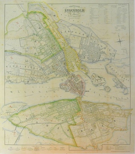
Stockholm - Mentzer ca 1860.
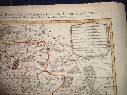
'Estats de Pologne Suboivisés suiuant l'estendue des Palatinats...' - Jaillot 1681, P. Mortier ca 1711.
