
1573-1649.
Engelsk upptäcktsresande och kartograf. Han studerade i Oxford och blev framförallt duktig i matematik. 1594 ledde han en expedition till Västindien och han var även i Orinoco och Ghana. Han slog sig senare ner i Florens där han höll pĺ med skeppsbygge och annat ingenjörsarbete. 1646-47 gav han ut ett stort verk, 'Dell Arcano del Mare' som i 6 delar behandlar sjörätt, praktiskt sjömanskap och navigation, skeppsbygge m.m., samt 131 sjökort över hela världen. En nyutgĺva kom 1661. Bĺda hör till rariteterna inom sitt omrĺde.
Bland arbeten.
Dell Arcano del Mare.
Phillips. - Tooley.
C:a 1550.
Kartograf verksam i Mecheln, Belgien. Styvfar till Franz Hogenberg.
Bland arbeten.
Encyclopédie ou dictionnaire universel raisonné des connaissances humaines.
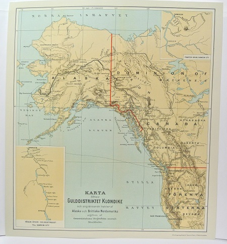
Gulddistriktet Klondike - ca 1897.
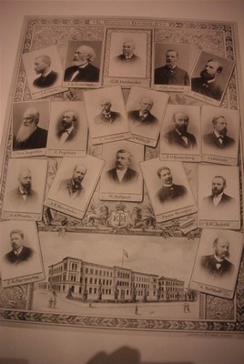
Kungliga Tekniska Högskolan - 'Sveriges Industri, dess Stormän och Befrämjare' ca 1900.
PTOLEMAIOS, CLAUDIUS (Ptolemaeus / Ptolemy).
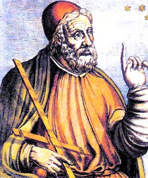
Biografiska uppgifter:Ca. 150 e. Kr.
Den äldre tidens mest berömda astronom, geograf och matematiker. Hans astronomiska teorier var ledande under 14 ĺrhundraden, och hans främsta verk, 'Syntaxis' eller 'Almagest', avlöstes inte förrän Newtons banbrytande forskning. Hans 'Geographia' dominerade hela den kristna och muhammedanska världen under 1500 ĺr. Det var Ptolemaeus som införde begreppen längd- och breddgrader, det system som geografin sedan dess följt i alla tider. Efter uppfinningen av boktryckerikonsten kom hans främsta geografiska verk helt eller delvis ut i en rad utgĺvor, som oftast kompletterades med senare forskningsresultat och nyare kartritningar. Till ĺr 1700 hade 45 utgĺvor pĺ mĺnga olika sprĺk utgivits. Sedan dess har ytterligare 7 utgĺvor tillkommit, den senaste ĺr 1883.
The 1482 edition of the Cosmographia, printed in Ulm, is one of the finest and most ambitious productions of the fifteenth century and the first printed atlas to include a corpus of “modern maps” as revised and supplemented by the important renaissance cartographer Dom Nicolaus Germanus. “The strictly classical world map goes no further than Thule, just to the north of Scotland, but the Ulm Ptolemy shows a rudimentary Scandinavia within an extension of the map’s top border…..No hint is given of the Portuguese exploration down the west coast of Africa nor of the existence of “modern” sea charts (portolani) showing the European and neighbouring coasts in great detail” (Shirley).
All fifteenth-century printed editions of Ptolemy were based on the work of Dom Nicolaus, a Benedictine monk from the diocese of Breslau, who prepared a series of magnificent vellum manuscript atlases in Florence in the 1460s and 1470s for various Italian dignitaries. The direct model for the Ulm edition was the manuscript atlas Dom Nicolaus made for presentation to Pope Paul II (d. 1471) which seems to have been carried from Rom to Ulm for that purpose and then never returned. It survives today at Schloss Wolfegg.
Bland arbeten:
World. Untitled map of the world. Ulm: Leinhart Holle, 1482 or later. Prepared by Donnus Nicolas Germanus and cut by Johannes “Schnitzer”.
This world map is from the first edition of Ptolemy to be printed north of the Alps, and the first to use woodcut maps. It is the earliest surviving printed map signed by its engraver, and the first in the Ptolemaic sequence to include Scandinavia and to allude to lands beyond the confines of Ptolemy’s world view.
(Salmonsen.- Tooley.) - Se bild.
