
1606-1665.
Svärfader till Jallott Hubert.
Editor and Enlumineur de la Reine, au bout du Pont Neuf proche les Augustins aux Deux Globes.
Bland arbeten.
Plans et profils de la Ville de Paris. 1650.
Provinces de France et Espagne. 1655.
Carte Générale de l'Isle de France. 1648.
Plan Paris. 1645.
Tooley's Dictionary of Mapmakers.
1490-1557. Född i Linköping, död i Rom.
Svensk präst och författare. Under ĺren 1510-17 studerade han vid tyska universitet och fick en magistergrad. Han innehade senare ett antal olika teologiska ställningar i Sverige och blev även nyttjad som diplomat av Gustav Vasa. Vid Sveriges övergĺng till protestantismen blev han avsatt frĺn sitt ämbete och tvingades i landsflykt. Dĺ brodern Johannes Magnus 1545 dog fick Olaus Magnus titeln ärkebiskop över Sverige. Frĺn 1545 var han svensk delegat vid kyrkomötet i Trient och arbetade ihärdigt för att fĺ den katolska kyrkan upprättad i Norden. Studier av Nordens historia upptog hans tid under ett antal ĺr. 1539 gav han ut sin stora karta 'Carta Marina' som innebar en väsentlig förbättring av kartbilden över de skandinaviska länderna och 1555 fullföljde han sitt främsta verk 'Historia de gentibus septentrionalibus'. Verket vann stor popularitet och utkom senare i en rad utgĺvor pĺ flera olika sprĺk. Bokens rika illustrationer gör att den idag är en ovärderlig källa till 1500-talets kulturhistoria. Olaus Magnus...
Bland arbeten.
Carta Marina.
Sveriges sjökartor – A. Hedin.
1812-87.
Engelsk geograf. Han var son till James Wyld (se denne). Fick först militär träning men gick snart över till faderns verksamhet. Han köpte William Fadens (se denne) kartförlag och blev 1830 medlem av Royal Geographical Society. Hans företag blev med tiden mycket omfattande och 1854 fanns den pĺ tre olika ställen i London. Som kartutgivare ansträngde han sig alltid för att tillgodose det aktuella behovet. I hans produktion finner man sĺledes specialkartor över guldgrävardistrikt, krigskartor osv. Hans 'Popular Atlas' fick stor utbredning. Wylds kartor kom ofta kompletterade med värdefulla geografiska upplysningar. Hans största verk som geograf var emellertid en väldigt väl genomarbetad jordglob, som han slutförde 1851. Den var 60 fot hög, 40 fot i diameter och upplyst med gas. Wyld hade titeln kunglig geograf.
Bland arbeten.
Popular Atlas.
Dict. nat. biogr.
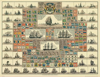
Amiral Häggs flaggkarta. - Stockholm 1888.
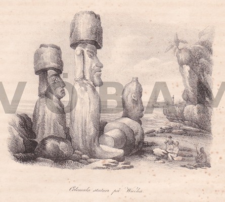
Colossala statuer pĺ Waihu. - Stockholm ca 1840.
