
(c. 1596, Neuhausen, – 1665, Hoorn)
Cellarius was a Dutch-German cartographer, best known for his Harmonia Macrocosmica of 1660, a major star atlas, published by Johannes Janssonius in Amsterdam.
He was born in Neuhausen (now a part of Worms), and was educated in Heidelberg. The Protestant Cellarius may have left Heidelberg at the onset of the Thirty Years' War in 1618 or in 1622 when the city came in Catholic hands. His activities are unclear at this time but based on his later works it is conjectured he spent time in Poland and may have even worked as a military engineer there. In 1625 he married Catharina Elt(e)mans in Amsterdam, where he worked as school master of a Latin School. After a brief stay in The Hague, the family moved to Hoorn. From 1637 until his death he was rector of the Latin School in Hoorn, where Pieter Anthoniszoon Overtwater was conrector.
He published on fortification and on Poland.
The minor planet 12618 Cellarius is named in his honour.
Andreas Cellarius
The Dutch-German mathematician and cosmogr...
Bland arbeten.
Harmonia macrocosmica sea atlas universalis et novus. Amsterdam: G. Valck and P. schenk, 1708.
Folio (530 x 320mm), allegorical title engraved by F. H. van Hoven, printed in red and black with woodcut vignette, letterpress title with contents and 29 double-page engraved cosmographical charts finely coloured by hand, without text.
One of the most fascinating achievement from the golden age of Dutch cartography. The Harmonia macrocosmica is the only atlas of the period dealing with astronomy.
Unlike the late celestial atlases, the Cellarius charts demonstrated various ancient and contemporary cosmological ideas, rather than just the names and positions of the stars. The purpose of the book was to assess different attempts to discover the underlying harmony of the universe. The charts represent the highest levels of seventeenth-century astronomical thought, with the diagram showing aspects of the three great theories on the nature of the universe; the Ptolemaic, the Copernican and the Brahean.
Se Aspegreen.
1630-99. Född i Banarps socken, död i Uppsala.
Svensk astronom. Studerade under ĺren 1652-63 i Greifswald och Uppsala och 1664-67 gjorde han en studieresa till en rad av Europas universitetsstäder. 1667 blev han professor i astronomi vid universitetet i Lund och inrättade där det första svenska observatoriet, som kom att ödeläggas under kriget med Danmark 1676-77. 1679 blev han professor i astronomi i Uppsala och inrättade där ett nytt observatorium. Han utgav flera läroböcker i astronomi och under flera ĺr även almanackor. Som astronom var han Erik Dahlbergs (se denne) rĺdgivare vid framställningen av dennes nya karta över Norden.
Lönborg. - Nordenmark.
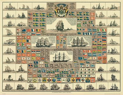
Amiral Häggs flaggkarta. - Stockholm 1888.
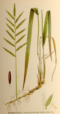
Spärrlosta, Brachypodium pinnatum - Lindman, C. A. M, Bilder ur Nordens Flora 1917-26.
MERCATOR, GERARD (Gerard de Cremere el. Kremer).
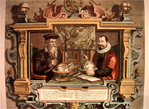
Biografiska uppgifter:5/3 1512- 2/12 1594. Född i Rupelmonde i Flandern, död i Duisburg.
Belgisk-tysk geograf. Frĺn 1530 studerade han vid universitetet i Leuven under astronomen och kartografen Gemma-Frisius (se denne), och var dennes assistent under arbetet med hans jordglob. Hans första självständiga arbete, en Palestinakarta frĺn 1537, finns det idag bara en känd kopia av. Lika sällsynta är flera av hans andra tidigaste arbeten. Ĺr 1541 konstruerade han en jordglob över jordklotet och en himmelsglob, bĺda pĺ uppdrag av kejsare Karl V. Ĺr 1552 slog han sig ned i Duisburg där han sedan fortsatte sin verksamhet. 1569 gav han ut en liten bok om kronologi och samma ĺr kom hans framstĺende världskarta. 1578 gav han ut Ptolemaeus geografi, kompletterad med sina egna kartor. Detta verk kom i 7 nyutgĺvor, den senaste 1794. Mercator är ansedd som den mest betydelsefulla geografen sedan Ptolemaeus. Hans främsta verk, 'Atlas, sive cosmographicae meditationes de fabrica mundi' utkom första gĺngen 1585 och slutfördes 1595, en kort tid efter hans död. Detta arbete var epokavgörande och kom fram till 1642 ut i 47 nyutgĺvor med text pĺ 6 olika sprĺk. Under sina sista levnadsĺr hade Mercator goda medhjälpare i sina söner Rumold Mercator (se denne) och Arnold Mercator (se denne), samt tre av sina sonsöner. Ingen av dessa förde emellertid hans verk vidare. 1604 sĺldes företaget till Jodocus Hondius. Pĺ grund av den stora efterfrĺgan pĺ Mercators atlas gav Jocodus Hondius ut en förminskad utgĺva, 'Atlas minor' (1607) som även den fick stor utbredning under en lĺng rad ĺr. Som kartograf tog Mercator i bruk en ny, cylindrisk kartprojektion som visade sig vara särskilt användbar för sjökort, och användes under flera ĺrhundraden.
For nearly sixty years, during the most important and exciting period in the story of modern map making, Gerard Mercator was the supreme cartographer, his name, second only to Ptolemy, synonymous with the form of map projection still in use today. Although not the inventor of this type of projection he was the first to apply it to navigational charts in such a form that compass bearings could be plotted on charts in straight lines, thereby providing seamen with a solution to an age-old problem of navigation at sea. His influence transformed land surveying and his researches and calculations led him to break away from Ptolemy's conception of the size and outline of the Continents, drastically reducing the longitudinal length of Europe and Asia and altering the shape of the Old World as visualized in the early sixteenth century.
Mercator was born in Rupelmonde in Flanders and studied in Louvain under Gemma Frisius, Dutch writer, astronomer and mathematician. He established himself there as a cartographer and instrument and globe maker, and when he was twenty-five drew and engraved his first map (of Palestine) and went on to produce a map of Flanders (1540) supervising the surveying and completing the drafting and engraving himself. The excellence of his work brought him the patronage of Charles V for whom he constructed a globe, but in spite of his favor with the Emperor he was caught up in the persecution of Lutheran protestants and charged with heresy, fortunately without serious consequences. No doubt the fear of further persecution influenced his move in 1552 to Duisburg, where he continued the production of maps, globes and instruments culminating in large-scale maps of Europe (1554), the British Isles (1564) and the famous World Map on 18 sheets drawn to his new projection (1569). All these early maps are exceedingly rare, some being known by only one copy.
In later life he devoted himself to his edition of the maps in Ptolemy's Geographia, reproduced in his own engraving as nearly as possible in their original form, and to the preparation of his 3-volume collection of maps to which, for the first time, the word 'Atlas' was applied. The word was chosen, he wrote, 'to honour the Titan, Atlas, King of Mauritania, a learned philosopher, mathematiciar, and astronomer' . The first two parts of the Atlas were published in 1585 and 1589 and the third, with the first two making a complete edition, in 1595 the year after Mercator's death.
Mercator's sons and grandsons, named above, were all cartographers and made their contributions in various ways to the great atlas. Rumold, in particular, was responsible for the complete edition in 1595. After a second complete edition in 1602, the map plates were bought in 1604 by Jodocus Hondius who, with his sons, Jodocus II and Henricus, published enlarged editions which dominated the map market for the following twenty to thirty years.
Bland arbeten:
Atlas, sive cosmographicae meditationes de fabrica mundi.
((Averdunk. - Bagrow. - Nederl. biogr. X.) ) - Se bild.
