
1747-1832.
Naval commission in 1764, retiring as vice-admiral 1790. The royal letter of discharge lauded him for his 'splendid fidelity and bravery.'
Sveriges sjökartor – A. Hedin.
Född 1779 26/12 i Eetikka, Kuopio sn (Kuopio), död 1854 i Stockholm, kastade sig i Norrström och omkom.
Kopparstickare och kartgravör. Son av landsgevaldigern Israel L. och Catharina Ulrika Blankensten. Utbildade sig pĺ egen hand som gravör. Var frĺn början av 1800-talet verksam i Sverige och inskrevs 1811 i finska förs. i Stockholm. Arbetade i stor utsträckning för Lantmäterikontoret och uppbar härför under en längre tid ett ĺrligt arvode av 300 rdr. »Anhĺlles att de, som ĺstunda kopparsticks-arbeten större eller mindre utförda af gravören Carl Gustaf Lundgren mĺtte helst sjelfwa … sig hos honom infinna . . . huset no 28 wid Regeringsgatan, lilla trappan frĺn gĺrdssidan 3 tr. upp.» (Dagl. Alleh. 1835 28/11.) Kämpade under senare ĺr med stora ekonomiska svĺrigheter, dĺ litografien vid mitten av 1800-talet alltmera började uttränga kopparstickskonsten.
Bland arbeten.
N. G. WERMING, Kartor öfver svenska städer, u. o. [1806-19]: 7 blad, bl. a. Karta öfver kanalen vid Södertelge 1806, Plan öfver slaget vid Enzersdorf 1809 och Läget af Carlskrona 1813.
Karta_över Kalmar län och Öland, 1818.
Karta över södra delen av Sverige och Norge, 1819-26, efter G. Af Forsell.
L. HAMMARSKÖLD, Beskrifning öfver kongl. lustslottet Rosersberg, Sthlm 1821: karta över Rosersbergs omgivningar, efter S. P. Nordstedt.
J. BERGGREN, Resor i Europa och Österländerna, I-III, Sthlm 1826-28: 3 titelvignetter,
bl. a. Hagia Sofia, kpst., och karta över Bosporen.
Hultmark, 1944.
Bland arbeten.
Encyclopédie ou dictionnaire universel raisonné des connaissances humaines.
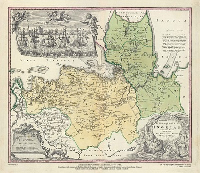
Ingermanlandiae – Homanns Erben 1734
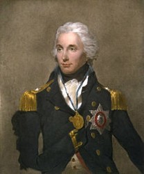
Lord Nelson, bust - Abbott, Lemuel Francis
