
1565-1629.
Petrus Bertius grew up in Beveren in Flanders and as a young man travelled widely in Europe. In company with so many of his compatriots he moved to Amsterdam as a refugee from religious persecution and after completing his studies there he was appointed a professor of mathematics and librarian at Leyden University. As well as being a prolific writer on mathematical, historical and theological subjects he is known as a cartographer for his editions of Ptolemy's Geographia (based on Mercator's edition of 1578) and for the miniature atlases detailed below. In 1618 he moved to Paris and became Official Cosmographer to Louis XIII. He was related by marriage to Jodocus Hondius and Pieter van den Keere.
16 april 1822 - 25 september 1878.
August Heinrich Petermann, f—dd 16 april 1822 i Bleicherode, Sachsen, d—d genom sjðlvmord 25 september 1878 i Gotha, var en tysk kartograf och geograf.
Petermann arbetade 1839-45 vid Heinrich Berghaus kartografiska institut i Potsdam, dðr han huvudsakligen sysslade med Berghaus 'Physikalischer Atlas'. Han tecknade ðven kartor till skrifter av Alexander von Humboldt. ér 1845 begav han sig till Edinburgh f—r att bitrðda Alexander Keith Johnston vid den engelska bearbetningen av nðmnda atlas och grundlade 1847 i London en kartografisk anstalt. ér 1854 anstðlldes han hos Justus Perthes i Gotha och utgav sedan 1855 'Mitteilungen aus Justus Perthes geographischer Anstalt', vilken tidskrift, vanligen kallad 'Petermanns Mitteilungen', blev ett centralorgan f—r den geografiska vetenskapen.
Som kartograf utmðrkte Petermann sig genom ett omsorgsfullt och kritiskt arbete med de mest skilda kðllor. Sðrskild kðnda ðr hans stora karta —ver det inre Afrika, hans karta i sex blad —ver USA samt hans karta i nio blad —ver...
Bland arbeten.
'Mitteilungen aus Justus Perthes geographischer Anstalt'
'Physikalischer Atlas'
'Stieler'
Nordisk Familjebok.
B. Smolenskoye, Vereysky district [now Moscow region], 1716-18; d. St Petersburg, 25 Feb 1770.
Russian draughtsman and engraver. He was the son of a priest, and from 1729 he studied at the St Petersburg Naval Academy. In August 1731 he was transferred to the instrument-making department of the Academy of Sciences, where he helped to make land-surveying instruments, including theodolites (a training that was of value when he later came to sketch views of St Petersburg); he also learnt how to carve moulds for dies under Georg Unfertsagt (1701-67); and he studied drawing under the two members of the Academy staff, Ottmar Elliger II and Elias Grimmel (1703-58). In June 1743 Makhayev was made director of the cartographic and die-carving section of the Academy, and he was employed there for the rest of his life. Together with his pupils he helped to produce the Atlas rossiyskoy imperii ('Atlas of the Russian Empire'; 1740s); in addition, he provided inscriptions for diplomas for honorary members of the Academy, for porcelain snuff-boxes and for a large silver shrine at the tomb of Aleksandr Nevsky (early 175...
Bagrow.
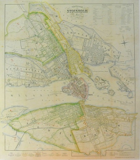
Stockholm - Mentzer ca 1860.
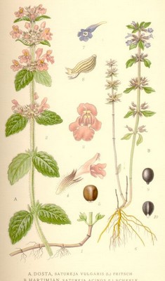
Dosta, Satureja Vulgaris (L.) Fritsch - Lindman, C. A. M, Bilder ur Nordens Flora 1917-26.
