
Född 1771 29/5, död under finska kriget 1808-09.
Fältväbel vid Ĺbo läns infanteriregemente. Kartograf och gravör.
.
Bland arbeten.
Karta över Skagshamn jämte stilprov.
Hultmark, 1944.
1733-1783.
Surveyor in Västerbotten province.
Sveriges sjökartor – A. Hedin.
Se Aspegreen.
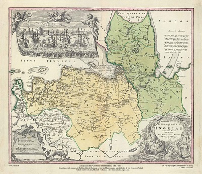
Ingermanlandiae – Homanns Erben 1734
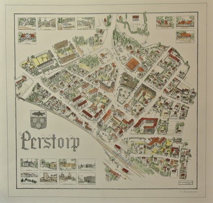
Perstorp - Bodo von Campenhausen 1977.
GERRITSZ [GERARD, GERARDUS, GHERRITSZOON van ASSUM].
Biografiska uppgifter:Hessel 1581-1632.
Gerritsz was apprenticed to W. J. Blaeu as an engraver before starting in business on his own account. He worked closely with Petrus Plancius and his merit may be judged by the fact that he was appointed Cartographer to the Dutch East India Company in preference to Blaeu and subsequently held the same position in a newly formed West India Company. With the new company he came into touch with Johannes de
Laet for whom he prepared a number of new maps of America in the latter's Nieuwe Wereldt published in 1625. His most important early work was a chart showing Henry Hudson's discoveries in his voyage of 1610-11: it is the first to give an outline of Hudson's Bay and indicates Hudson's belief that he had found a way to the North West Passage.
Engraver, cartographer, publisher and bookseller, b. Assum, apprenticed as engraver to Blaeu, Cartographer to Dutch E. India Co. 1617, fl. 1607; from 1612 using sign 'in de Paskaert' or 'sub signo Tabulae Nauticae'. Addresses: (1) opt Water bij die oude Brug [1609], (2) by die Lienbaens Brugh [1616], (3) Nieuwe Zijds Voorburgwal [1624], (4) Doelestraat [1627-32].
Engraved 17 Netherlands (1608?, lost)
Gulick Cleve 1610,
Spain 1612-(15),
Besch. van de Samoyeden Landt 1612,
Besch. van de Zeecusten van Ierlandt 1612,
engd. Blaeu's Lithuania 1613,
Russia 1613,
Italy 1617,
MS charts E. Indies, Pacific & c. 1617-22,
maps in Laet's Novus Orbis 1625,
Eendrachts' Land (W. Australia) 1627,
Rotario W. Indies & S. America 1628-32 MSS.
(Tooley.)
