
Caspar Henne(n)berg(er) (sometimes also 'Kaspar'.
1529 – 29 February 1600.
Was a German Lutheran pastor, historian and cartographer.
Hennenberger was born in a Franconian place given as Erlich (Erlichhausen?) and started to study Lutheran divinity at the University of Königsberg in 1550. In 1554 he began to work at the congregation of Georgenau and in Domnau. Probably in 1561 he moved to Mühlhausen, where he worked as a Lutheran Pastor for the next 29 years.
With the patronage of Duke Albert of Prussia Hennenberger published the first detailed map of Prussia in 1576, the book 'Kurze und wahrhaftige Beschreibung des Landes zu Preussen' (short and truthful description of the land Prussia) in 1584 and 'Erklärung der preußischen größeren Landtafeln oder Mappen' (explanation of the larger Prussian maps) in 1594.
In 1590 Hennenberger became the Pastor of the Large Hospital at Königsberg-Löbenicht, where he died in 1600. He was buried in the Hospital's Church.
Bland arbeten.
Kurze und wahrhaftige Beschreibung des Landes zu Preussen.
Erklärung der preußischen größeren Landtafeln oder Mappen.
Bland arbeten.
Encyclopédie ou dictionnaire universel raisonné des connaissances humaines.
Född 1732 15/1 i Valsberga, Ĺkers sn (Söd.), död 1797 4/11 pĺ Brĺtorp i ovann. sn.
Kommissionslantmätare. Kartgravör. Son av kronolänsmannen Olof Ĺ. och Maria Ekström. Student vid Uppsala universitet 1754. Blev sedan enligt egen utsago »informator hos löjtnant Ridderhjerta, dels ock vid Kungsör hos slottsinspektoren Jesper Petrseus att informera dess dotterson Jesper Gillberg, hvarmed fortsattes till 1756. Ĺr 1757 antog jag station hos akademigravören Ĺkerman, hvilken jag hjälpte med gravyr af bokstäfver, sĺ att jag fanns skicklig gravera alla namn, som stĺ pĺ den första här i riket utgifna jordgloben med en fots diameter, fast jag ej fick hedern att mitt namn sattes pĺ globen» (EKSTRAND). Kommissionslantmätare 1781. Ägde Brĺtorp.
Bland arbeten.
A. BERCH, Oeconomisk beskrifning öfver Wadsbo härad uti Westergöthland och Skaraborgs höfdingedöme, diss., resp. G. F. Bergman, Uppsala 1759: karta över Vadsbo härad.
Karta över Tveta härad i Smĺland. 17601.
Stockholms magazin, 1780: striden vid Brunnbäck jämte karta över Grytnäs och Folkärna socknar, efter G. Halstenson 1652.
Svenskarna under Wilhelm Carpelan förstöra den preussiska flottiljen i Frisches Haff 1759, efter C. Rutensparre, kpst.
Hultmark, 1944.
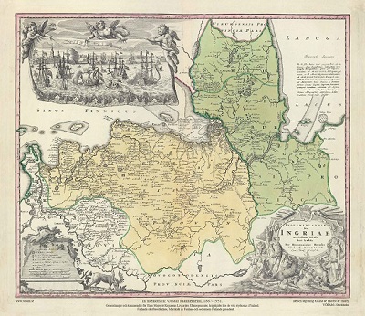
Ingermanlandiae – Homanns Erben 1734
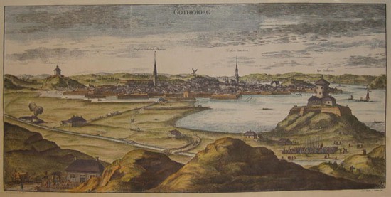
Göteborg - Svecia Antiqua et Hodierna.
