
1727-89. Född i Köpenhamn, död i Alleslev.
Dansk präst. Började studera 1745 och tog en teologiexamen 1747. 1754 verkade han vid Holmens kyrka i Köpenhamn, och 1762 som sockenpräst i Alleslev i Prestö län. Han utvecklade ett rikt författarskap, särskilt i geografiska och historiska ämnen. En del av hans produktion bestod av läroböcker. Ett särskilt förtjänstfullt, men inte avslutat arbete, var 'Den kgl. Hoved- og Residentz-Stad Kiöbenhavns Beskrivelse' (1783).
Bland arbeten.
Den kgl. Hoved- og Residentz-Stad Kiöbenhavns Beskrivelse.
Bricka. - Ehrencron.
1706-84.
Engelsk kartograf. Han utarbetade en 'Universal Atlas' som kom i flera utgĺvor, även efter hans död. (4:e ed., 1790).
Bland arbeten.
Universal Atlas.
Phillips.
Ca. 1590-1664. Född i Arnheim, död i Amsterdam.
Holländsk bokhandlare och kartograf. Han var först bokhandlare i sin födelsestad men flyttade till Amsterdam efter att han 1612 gift sig med en av Jodocus Hondius döttrar. Ĺr 1616 kom hans första egna kartarbeten, som var kartor över Frankrike och Italien. 1617 gav han ut Ptolomaeus geografi. Han lagade även jordglober. Tillsammans med sin svĺger Henrik Hondius gav han 1633 ut Mercator-Hondius atlasen i tvĺ band och 1635 gav han ut ytterligare tre band. Flera utgĺvor följde och det blev slutligen 6 band. 1637 gav han ut sjökartverket 'Le Nouveau Phaot de la Mer' med 51 kartor. 1657 kom 'Theatrum exhibens illustriores.. civitates' i 8 band, och under ĺren 1658-61 'Novus Atlas' i 11 band. Janssonius hade en utbredd verksamhet i Skandinavien. I Köpenhamn lĺg en betydande filial och 1647 drev han ett tryckeri med bokhandel i Stockholm. 1650 arbetade även hans son med detta, men ingen av dem upphöll sig i Stockholm. Filialen där drevs av en ställföreträdare som 1664 övertog tryckeriet för egen räkning. Janssonius...
Bland arbeten.
Le Nouveau Phaot de la Mer.
Theatrum exhibens illustriores.. civitates.
Novus Atlas.
Kleerkooper. - Klemming. - Skĺne. - Tooley.
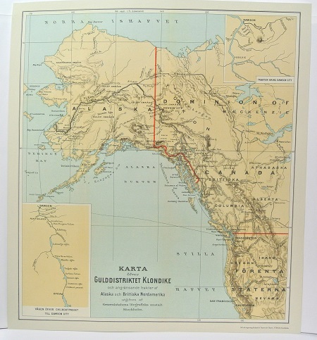
Gulddistriktet Klondike - ca 1897.

Starenflycht - C. H. Tersmeden ca 1900.
BLAEU, WILLEM JANSZOON (Guilielmus Janssonius).
Biografiska uppgifter:1571-1638. Född i Uitgeest vid Alkmaar, död i Amsterdam.
Holländsk kartograf. 1591 kom han till Ven som elev till Tycho Brahe. Förutom astronomi lärde han sig även att arbeta med matematiska instrument, glober och kartor. 1596 slog han sig ned i Amsterdam där han grundade en affär med kartor och nautiska instrument. 1605 gav han ut en stor världsatlas i 18 delar. Senare följde en rad specialkartor och 1617 ett verk med sjökort, 'Licht der Zee-vaert', som även kom med fransk och engelsk text. 1629 gav han ut sin första hela atlas med 54 kartor. Av dessa hade han övertagit de flesta frĺn Henr. Hondius. Under Willem Blaeus livstid följde fyra nyutgĺvor, kompletterade med nya kartor. Verket fördes senare vidare av hans söner. Familjen Blaeus verksamhet spände över alla delar inom geografi, kosmografi, hydrografi, topografi etc. Firmans produktion är känd som sin tids yppersta kartografiska arbeten, och räknas dessutom till de vackraste kartarbeten som överhuvudtaget utförts.
Willem Blaeu förväxlas ibland med Jan Jansson (Johan Janssonius). Oftast gäller detta kartor producerade innan 1619 dĺ Blaeu signerade sina verk Guilielmus Janssonius eller Willems Jans Zoon. Saken görs inte bättre av att Jansson anklagades för att kopiera Blaeus kartor. Senare gick Blaeu över till att skriva Guilielmus eller G. Blaeu. (BL)
Bland arbeten:
Licht der Zee-vaert.
(Nederl. biogr. , X. - Richter. - Tooley.) - Se bild.
