
(c. 1596, Neuhausen, – 1665, Hoorn)
Cellarius was a Dutch-German cartographer, best known for his Harmonia Macrocosmica of 1660, a major star atlas, published by Johannes Janssonius in Amsterdam.
He was born in Neuhausen (now a part of Worms), and was educated in Heidelberg. The Protestant Cellarius may have left Heidelberg at the onset of the Thirty Years' War in 1618 or in 1622 when the city came in Catholic hands. His activities are unclear at this time but based on his later works it is conjectured he spent time in Poland and may have even worked as a military engineer there. In 1625 he married Catharina Elt(e)mans in Amsterdam, where he worked as school master of a Latin School. After a brief stay in The Hague, the family moved to Hoorn. From 1637 until his death he was rector of the Latin School in Hoorn, where Pieter Anthoniszoon Overtwater was conrector.
He published on fortification and on Poland.
The minor planet 12618 Cellarius is named in his honour.
Andreas Cellarius
The Dutch-German mathematician and cosmogr...
Bland arbeten.
Harmonia macrocosmica sea atlas universalis et novus. Amsterdam: G. Valck and P. schenk, 1708.
Folio (530 x 320mm), allegorical title engraved by F. H. van Hoven, printed in red and black with woodcut vignette, letterpress title with contents and 29 double-page engraved cosmographical charts finely coloured by hand, without text.
One of the most fascinating achievement from the golden age of Dutch cartography. The Harmonia macrocosmica is the only atlas of the period dealing with astronomy.
Unlike the late celestial atlases, the Cellarius charts demonstrated various ancient and contemporary cosmological ideas, rather than just the names and positions of the stars. The purpose of the book was to assess different attempts to discover the underlying harmony of the universe. The charts represent the highest levels of seventeenth-century astronomical thought, with the diagram showing aspects of the three great theories on the nature of the universe; the Ptolemaic, the Copernican and the Brahean.
Montanus, Petrus. [Pieter van den Berg]
ft. 1606.
A Dutch geographer, active in Amsterdam, who worked in association with his brother-in-law, J odocus Hondius, for whom he prepared the text of the Mercator/Hondius Atlas (1606 and later editions). The map noted below, attributed to Montanus, is the first separately printed one of Maryland; known as 'Lord Baltimore's Map' it was published by him to attract settlers to the colony.
CANTEMIR, PRINCE CONSTANTIN DIMITRI.
1673-1723.
Cartographer in Russian service.
Bland arbeten.
Moldavia 1716.
Constantinople 1720.
A contemporary unsigned English mezzotint portrait exists.
Tooley.
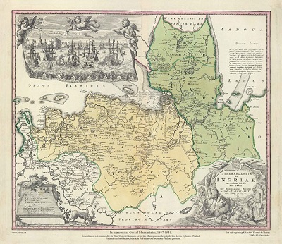
Ingermanlandiae – Homanns Erben 1734
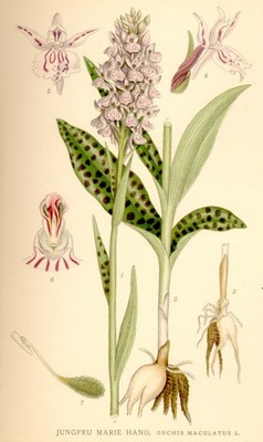
Jungfru Marie hand, Orchis maculatus - Lindman, C. A. M, Bilder ur Nordens Flora 1917-26.
