VÖBAM - Din källa till den äldre bild- och kartvärlden. - Tel: 08-102121 - Epost: info@vobam.se
Biografier.

BRAUN, GEORG.

1541-1622.
Teolog och förläggare. Mest känd för sin medverkan i utgivningen av 'Civitates Orbis Terrarum' där han även utförde texterna. Verksam som lärare i Antwerpen 1566-1568 där han träffade Franz Hogenberg. Efter Hogenbergs flytt till Köln 1570 träffades Braun och Hogenberg igen och inledde ett samarbete. I ett brev från Braun till Ortelius daterat 31 oktober 1571 så insinuerar Braun att 'Civitates Orbis Terrarum' var Hogenbergs idé då han kallar den 'Mäster Frans' bok om städer'. Arbetets första del utkom 1572 och slutfördes först 1618.

Bland arbeten.
Civitates Orbis Terrarum.


HOMEM, DIOGO.


Kartograf. Gav ut en atlas i Portugal 1559


(RdeT.


Stacpoole, Frederick.

(b 1813; d London, 19 Dec 1907).
English engraver. He was educated in Ghent, Belgium, and later at the Royal Academy Schools, London, where he was awarded silver medals in 1839 and 1841. He worked in the mixed mezzotint style and exhibited 43 examples of his work at the Royal Academy between 1841 and 1893. Of Stacpoole’s many plates, perhaps the best-known are those after William Holman Hunt’s Shadow of Death (1873; Manchester, C.A.G.) and the battle subjects of Lady Butler. Stacpoole began work early in 1874 on the engraving of Shadow of Death . The original picture had been bought by Thos Agnew & Sons and was exhibited so widely that, on publication of the engravings in 1877, the sale of proofs alone realized more than £20,000. By January 1879 Stacpoole had received a total of £3560 from the Fine Art Society for his plates after Lady Butler’s Roll Call (1874; British Royal Col.; declared for publication in 1874), Quatre Bras (1875; Melbourne, N.G. Victoria) and Balaclava (1876; Manchester, C.A.G.; both declared in 1876).
Bland arbeten.
Shadow of Death (1873; Manchester, C.A.G.), Lady Butler’s Roll Call (1874; British Royal Col.; declared for publication in 1874), Quatre Bras (1875; Melbourne, N.G. Victoria) and Balaclava (1876; Manchester, C.A.G.; both declared in 1876).


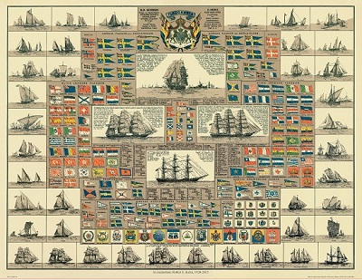
Amiral Häggs flaggkarta. - Stockholm 1888.
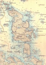


Singö. - 1876.


Sök efter biografi:

Du sökte på: 10563

Klicka på valfri bokstav för att återgå till hela listan.  

A  B  C  D  E  F  G  H  I  J  K  L  M  N  O  P  Q  R  S  T  U  V  W  X  Y  Z  Å  Ä  Ö

Covens et Mortier

Biografiska uppgifter:1721 - ca 1862.
The Amsterdam publishing firm of Covens and Mortier (1721 - c. 1862) was the successor to the extensive publishing empire built by Frenchman Pierre Mortier (1661 - 1711). Upon Mortier's death in 1711 his firm was taken over by his son, Cornelius Mortier (1699 - 1783). Cornelius married the sister of Johannes Covens (1697 - 1774) in 1821 and, partnering with his brother in law, established the Covens and Mortier firm. Under the Covens and Mortier imprint, Cornelius and Pierre republished the works of the great 17th and early 18th century Dutch and French cartographers De L'Isle, Allard, Jansson, De Wit, and Ottens among others. They quickly became one of the largest and most prolific Dutch publishing concerns of the 18th century. The firm and its successors published thousands of maps over a 120 year period from 1721 to the mid-1800s. During their long lifespan the Covens and Mortier firm published as Covens and Mortier (1721-1778), J. Covens and Son (1778 - 94) and Mortier, Covens and Son (1794 - c. 1862)

Under the heading Pieter Mortier we give some details of the extensive publishing business which he built up in Amsterdam and which, after his death, was subsequently taken over by his son, the above-named Cornelis. In 1721 Cornelis married the sister of Johannes Covens and in the same year he and Johannes entered into partnership as publishers under the name Covens and Mortier which, with its successors, became one of the most important firms in the Dutch map publishing business.
Their prolific Output over the years included reissues of general atlases by Sanson, Jaillot, Delisle, Visscher, de Wit (whose stock they acquired) and others (often with re-engraved maps), atlases of particular countries including Germany, England and Scotland and others in Europe, pocket atlases, town plans and, from about 1730 onwards, a series under the title Nieuwe Atlas, some consisting of as many as 900 maps by various cartographers and publishers. As there is no conformity about these volumes they were presumably made up to special order and only general details of publication can be quoted in a work of this size.

Tillbaka till början.