
1851-1914.
Norsk ingenj÷r. 1874 fick han anstõllning som ingenj÷r vid 'Vassdragsvesenet' dõr han sedan verkade. Han deltog mycket i mõtningsarbeten ÷ver hela Norge och utf÷rde ett grundlõggande unders÷kningsarbete vid f÷rberedelserna av Bandakkanalen. F÷rutom Norgekartor gav han õven ut specialkartor ÷ver Bandak-Nordsj÷kanalen samt ÷ver strõckan Christiania-Bergen.
T U. 1914. - U.B.
1552-1612.
Vrients was the map engraver and publisher in Antwerp who, after the death of Ortelius in 1598, acquired the publication rights of the Theatrum. Between 1601 and 1612 he issued a number of editions which included some of his own maps and he was responsible for printing the maps for the English edition in 1606. He also published a number of important individual maps and a small atlas of the Netherlands.
d'ANVILLE, JEAN-BAPTISTE BOURGUIGNON.
1697-1782. F÷dd och d÷d i Paris.
Fransk geograf, Redan i sin tidigaste ungdom õgnade han sig Õt geografiska och antika studier. 15 Õr gammal utarbetade han en karta ÷ver det gamla Hellas. 1727 gav han ut en karta ÷ver Afrika som f÷ljdes av 'Atlas de la Chine'. En 'Geographie Ancienne' kom i en rad utgÕvor pÕ olika sprÕk fram till 1815, flera Õr efter hans d÷d. Han utarbetade ett flertal kartor frÕn alla jordens h÷rn, utgivna i samlingar utan speciella titelblad. Medlem av 'L'AcadÚmie des inscriptions et belles-lettres och L'AcadÚmie royale des sciences.'
Bland arbeten.
Atlas de la Chine.
Geographie Ancienne.
Nouv. biogr. gen. - Philips.

Võgvisare f÷r XI Olympiaden i Berlin - 1936
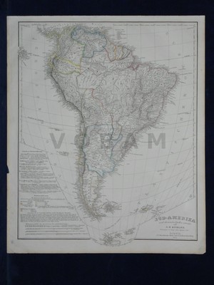
'S³d-Amerika.' - A. H. K÷hler 1854.
