LISLE, GUILLAUME de.
Biografiska uppgifter:1675-1726. Född och död i Paris.
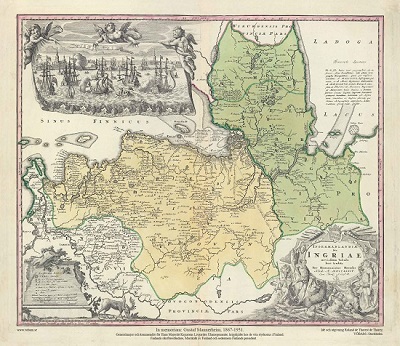
Fransk geograf och kartograf. Han fick sin utbildning hos sin far, historiken Claude de Lisle, som även var geograf. 1699 gav han ut en världskarta, kartor över de 4 världsdelarna och tvĺ glober, en över jordklotet och en över himlen. Runt 1700 kom hans 'Atlas Nouveau' som innehöll 24 kartor. Senare utgĺvor kom ca 1730 med 54 kartor, 1733 och ca 1745 utökad till 116 kartor. Han blev 1702 invald i L'Académie Rle de Sciences och blev 1718 Premier Geographe du Roi. Han var vän till Peter den Store som gav honom upplysningar om Ryssland. De Lisles kartor blev i stor utsträckning efterliknade av samtidiga och senare kartografer, till viss del grovt plagierade. Han gjorde sig även gällande som författare. Förutom talrika avhandlingar i tidskrifter utgav han bl.a. 'Observation sur la variation de l'aiguille aimantée' (1710) och 'Justification des mesures des anciens en matičre de géographie' (1714). Hans verk fördes vidare av Phillippe Buache (1700-73).
Guillaume De L'Isle (1675-1726) is probably the greatest figure in French cartography. Having learned geography from his father Claude, by age of eight or nine he could draw maps to demonstrate ancient history. He studied mathematics and astronomy under J.D Cassini, where he received the grounding in scientific cartography, that is the hallmark of his work. His first atlas was published in about 1700, in 1702 he was elected a member of the Academie Royale des Sciences, and in 1718 he became ‘Premier Geographe du Roi’. His maps of the newly explored parts of the world reflect the most up-to-date information available and did not contain fanciful detail in the absence of solid information.
De L'Isle's work was important as marking a transition from the maps of the Dutch school, which were highly decorative and artistically-orientated, to a more scientific approach. He reduced the importance given to the decorative elements in maps, and emphasised the scientific base on which they were constructed. It can be fairly said that he was truly the father of the modern school of cartography at the commercial level.
De L’Isle also played a prominent part in the recalculation of latitude and longitude, based on the most up-to-date celestial observations. His major contribution was in collating and incorporating this latitudinal and longitudinal information in his maps, setting a new standard of accuracy, quickly followed by many of his contemporaries. Guillaume De L’Isle’s work was widely copied by other mapmakers of the period, including Chatelain, Covens & Mortier, and Albrizzi.
Bland arbeten:
Atlas Nouveau.
Observation sur la variation de l'aiguille aimantée.
Justification des mesures des anciens en matičre de géographie.
(Lönborg, s. 143f. - Nouv. biogr. gen)
Tillbaka till början.