
Was the most important member of an Augsburg family of artists and publishers. He was the German representative of the 'Vue d'Optique' , a genre of copper engravings showing in the size of this here shown print the architectural 'wonders of the world' to people mainly during fairs. The prints were pushed into a view box and the viewers, one at a time, could look through a lens to see the prints inserted into the box by the operator, for money, of course. There were French, Italian, Spanish, publishers of Vue d'Optique prints. But the most famous and the most true to facts ones came from the Augsburg workshop of G.B. Probst. He produced ca. 400 of them, not only views of places, but also a variety of other subject matters. While most prints of this genre were loudly and heavily colored, a small series was left black and white, truly showing their artistic value beyond the fulfilment of curiosity at fairs.
1766-1832. F—dd i Fredrika, d—d i Christiania (Oslo).
Dansk-norsk officer 1789. 1791 beordrad att kartlðgga Kongsbergs gruvomrÍde. 1796 tog han avsked som officer med kaptens grad och slutf—rde sitt kartlðggningsarbete Íret dðrpÍ. Han var sedan chef vid Kongsbergs silvergruva tills han 1810 slog sig ned i Krager— som trðhandlare. Boeck var flera gÍnger stortingsman och blev 1832 medlem i 'Huvudmatrikuleringskommissionen'.
A. Collett: Familjen Collett.
1744-1820. F—dd och d—d i Stockholm.
Svensk kartograf och friherre. 1770 blev han bergsmðstare och 1781 bergsrÍd. Han gjorde ðven en f—rtjðnstfull insats som kartograf genom att ta upp en gammal plan om geografisk beskrivning och kartlðggning av Sverige och Finland. Verket pÍb—rjades 1795 och avslutades 1818 med totalt 33 kartor med titeln 'Geographiske chartor —fver Swerige i 4 afdelingar'. Det 'Hermelinska kartverket', som ðr den f—rsta svenska rikskartan i atlasform, fick stort erkðnnande. Arbetet med kartorna f—rsatte honom i svÍra ekonomiska omstðndigheter. Hermelin var medlem av en rad lðrda sðllskap bÍde i Sverige och utomlands.
Bland arbeten.
Kartor i verket Geographiske chartor.
Finland.
1. Storfurstend—met Finland.
2. Nylands och Tavastehus samt Kymmene-gÍrds h—fdinged—men.
3. Savolax och Karelens eller Kuopio h—fdinged—men.
4. UleÍborgs h—fdinged—me.
5. Wasa h—fdinged—me.
6. ébo och Bj—rnebergs h—fdinged—me med éland.
Sverige.
1. Swerige med tillgrðnsande lðnder.
2. Carlstads h—fdinged—me eller Wðrmeland. (2 blad).
3. Elfsborgs h—fdinged—me.
4. G—ta rike eller S—dra delen af Sverige.
5. G—teborgs och Bohuslðns h—fdinged—me.
6. Halmstads h—fdinged—me eller Halland.
7. Helsingland och Gestrikland.
8. HerjeÍdalaen.
9. J—nk—pings, Kronobergs och Blekings h—fdinged—men.
10. Kalmar h—fdinged—me med øland.
11. Kopparbergs Sðters, NðsgÍrds och Wester bergslags f—gderier i St. Kopparbergs h—fd.
12. Link—pings h—fdinged—me eller østerg—tland.
13. Nyk—pings h—fdinged—me.
14. Skaraborgs h—fdinged—me.
15. SkÍne eller Malm—hus och Christianstads h—fdinged—men. (2 blad).
16. Stockholms h—fdinged—me.
17. Stora Kopparbergs h—fdinged—me eller Dalarne.
18. Svea rike och Norrland.
19. Upsala h—fdinged—me.
20. Westerbotten och Lappmarken, eller UmeÍ h—fdinged—me.
21. WesterÍs h—fdinged—me.
22. Wisby h—fdinged—me eller Gottland.
23. éngermanland, Medelpad och Jðmtland eller Wester Norrlands h—fdinged—me.
24. ørebro h—fdinged—me.
I atlasen ingÍr ðven 3 vyer / utsikter.
1. Utsigt af ett Wattenfall i Lappmarken.
2. Utsigt af en Belðgenhet i Finland.
3. Utsigt af Stockholm.
Totalt 33 kopparstick.
(L—nborg, s. 193-209. - Sv. mðn och kv.
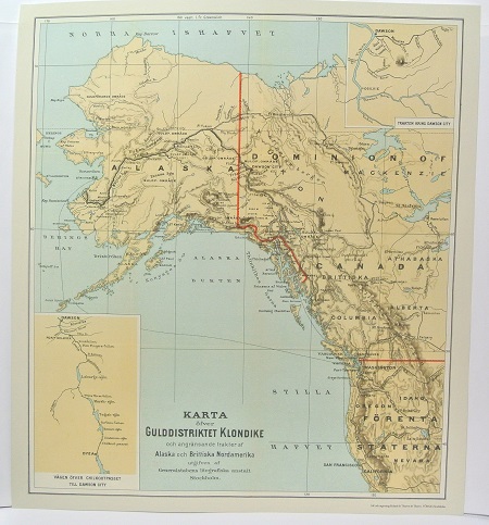
Gulddistriktet Klondike - ca 1897.
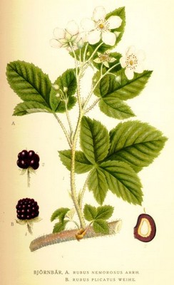
Bj—rnbðr, Rubus nemorosus - Lindman, C. A. M, Bilder ur Nordens Flora 1917-26.
