VÖBAM - Din källa till den äldre bild- och kartvärlden. - Tel: 08-102121 - Epost: info@vobam.se
Biografier.

MALLET, ALAIN MANESSON.

1630-1706. Född och död i Paris.
Fransk ingenjör. Efter en tids verksamhet som militäringenjör hos kungen av Portugal återvände han till Paris och blev matematiklärare åt Ludvig XIV:s pager. 1671 utgav han ett militärtekniskt verk, 'Les travaux de Mars, ou l'art de la guerre'. Ett geografiskt verk i 5 band med en mängd kartor och planer, 'Description de l'Univers, contenant les différens systemes du Monde' utkom 1683 och i nyutgåva 1685. 1702 lät han utge 'La Géométrie pratique' i 4 band.

Description de L'Universe
His Description de L'Universe contains a wide variety of information, including star maps, maps of the ancient and modern world, and a synopsis of the customs, religion and government of the many nations included in his text. It has been suggested that his background as a teacher led to his being concerned with entertaining his readers. This concern manifested itself in the charming harbor scenes and rural landscapes that he included beneath his description of astronomical concepts and diagrams. Mallet himself drew most
...
Bland arbeten.
Les travaux de Mars, ou l'art de la guerre.
Description de l'Univers, contenant les différens systemes du Monde.
La Géométrie pratique.


Nouv. biogr. gen.


Gassicourt, Louis-Claude Cadet de.


Bland arbeten.
Encyclopédie ou dictionnaire universel raisonné des connaissances humaines.


KEULEN, JOHANNES van.

1653-1715.
In 1680 was given special endorsement from the Dutch state to print and publish sea charts and sailing instructions. The van Keulen family's best-known work is Nieuwe Groote Ligtende Zee-Fakkel a world atlas in five volumes, published by Johannes's son Gerard and subsequently by Gerard's children and grandchildren.

As we have noted in other biographies in this chapter, the Dutch produced a remarkable number of enterprising and prolific map and chart makers but not even the Blaeu and Jansson establishments could rival the vigour of the van Keulen family whose business was founded in 1680 and continued under their name until 1823 and in other names until 1885 when it was finally wound up and the stock dispersed at auction. Throughout the history of the family, the widows of several of the van Keulens played a major part, after their husbands' deaths, in maintaining the continuity of the business.
The firm was founded by Johannes van Keulen who was registered as a bookseller in Amsterdam in 1678. In 16
...


Sveriges sjökartor – A. Hedin.


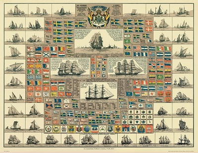
Amiral Häggs flaggkarta. - Stockholm 1888.
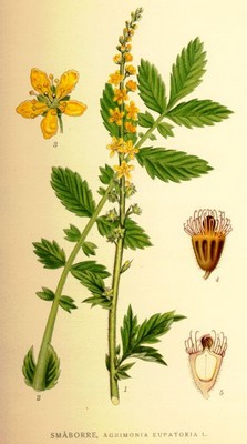


Polcirkeln. - Blaeu 1643/44.


Sök efter biografi:

Du sökte på: NAUCLERUS

Klicka på valfri bokstav för att återgå till hela listan.  

A  B  C  D  E  F  G  H  I  J  K  L  M  N  O  P  Q  R  S  T  U  V  W  X  Y  Z  Å  Ä  Ö

NAUCLERUS, OLOF (OLAUS).

Biografiska uppgifter:1626-1706.
Svensk bergsman och lantmätare. Efter studier i Uppsala blev han 1657 anställd vid Bergsväsendet. Då Tröndelag vid freden 1658 tillföll Sverige följde han som lantmätare den svenske regeringskommissarien Lorentz Creutz på dennes resa till Trondheim för att fastställa de nya gränserna. Förutom gränsmätningen utförde han även ett flertal grundplaner av Trondheim stad, Domkyrkan m.m. Efter att svenskarna drivits tillbaka från Norge, återupptog Nauclerus sin verksamhet i Bergsväsendet och blev 1665 chef vid Stora Kopparberget i Dalarna.

Tillbaka till början.