
F÷dd i Gotha och d÷d 22 mars 1827 i S.t Petersburg.
Graverade illustrationer till b÷cker samt portrńtt.
1659-1733.
Hollńndsk boktryckare och kartograf. 1694 blev han boktryckare f÷r Waalsche College i Leiden, och fick senare titeln stads- och akademiboktryckare. 1714 utgav han en 'Atlas Nouveau et Curieux' med 139 kartor, och samma ňr 'Atlas Nouvel' med 98 kartor. 1729 fullf÷ljde han med 'Gallerie Agreeable du Monde', ett storverk i 66 band med ca. 3000 planscher. Upplagan var begrńnsad till 100 exemplar.
Bland arbeten.
Atlas Nouveau et Curieux.
Atlas Nouvel.
Gallerie Agreeable du Monde.
Nederl. biogr., I. - Tooley.
1528-98.
Graverade vissa av kartorna till Waghenaers (se denne) sj÷atlas. Arbetade ocksň med s÷nerna Joh. Israel och Johann Thoedore (se dessa). Tillsammans gav de bl a. ut verket 'India Orientalis' som kom i flera band omkring 1599 och i senare utgňvor.
Bland arbeten.
India Orientalis.

Vńgvisare f÷r XI Olympiaden i Berlin - 1936
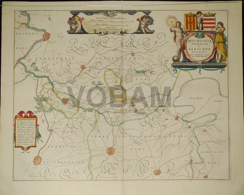
Mechelen, Aarschot. - Blaeu 1643/44.

Biografiska uppgifter:KÔtip ăelebi, Mustafa bin Abdullah, Haji Khalifa or Kalfa, (1609, Istanbul ľ 1657 Istanbul)
KÔtip Celebi was an Ottoman scholar. A historian and geographer, he is regarded as one of the most productive authors of non-religious scientific literature in the 17th century Ottoman Empire. Among his best-known works is the Kashf al-?un?n Ĺan as?m? al-kutub wa-al-fun?n, ('The Removal of Doubt from the Names of Books and the Arts'), a bibliographic encyclopaedia, written in Arabic, which lists more than 14,500 books in alphabetic order.
Life and works
The son of a soldier, he himself was a soldier for ten years until a heritage made him turn to a more contemplative life. As the accountant of the commissariat department of the Ottoman Army in Anatolia, he accompanied the Ottoman army in the campaign against Baghdad in 1625, was present at the siege of Erzurum, and returned to Istanbul in 1628. In the following year he was again in Baghdad and Hamadan, and in 1633-34 at Aleppo, whence he made the pilgrimage to Mecca (hence his title Hajji). The following year he was in Erivan and then returned to Constantinople. Here he obtained a post in the head office of the commissariat department, which afforded him time for study. He seems to have attended the lectures of great teachers up to the time of his death, and made a practice of visiting bookshops and noting the titles and contents of all books he found there.
One of his shorter and more accessible works is M?z?n al-?aqq f? ikhtiy?r al-a?aqq ('The balance of truth in the choice of the truest'), a collection of short essays on topics in Islamic law, ethics, and theology, in which he takes a relatively liberal and tolerant viewŚoften critical of narrow-minded Islamic religious authorities. This book serves as a source on Ottoman social developments in the 16th and 17th centuries, such as the introduction of coffee and tobacco. While he did not concur with the outlawing of coffee and tobacco, he found tobacco smoke personally distasteful, writing of the 'noxious effects of the corruption of the aerial essence.' An English translation by G. L. Lewis of the M?z?n al-?aqq has been published with annotations under the title The Balance of Truth.
Katip ăelebi died suddenly and peacefully in October 1657, while drinking a cup of coffee.
Bland arbeten:
CihannŘma (The mirror of the world) Constantinople, Ibrahim MŘteferrika, 1732. First edition.
This is the second work by KÔtip Celebi published in 1729. The author was a well known writer on history and geography and a bibliophile and in this work intended to publish a universal system of geography. In fact only part of the work (including the description of Asia Minor) was completed by KÔtip who used European and Arabic and Persian sources, and the whole was supplemented and edited by Ibrahim, who dedicated it to the grand vizir of Sultan Mahmud II, Ali Pasha.
The picture is showing the map of the Indian Ocean and the China Sea that was engraved in 1728 by the Hungarian-born Ottoman cartographer and publisher Ibrahim MŘteferrika; it is one of a series that illustrated Katip ăelebiĺs Cihannuma (Universal Geography), the first printed book of maps and drawings to appear in the Islamic world.
- Se bild.
