
Född d. 18 maj 1717. Död i Stockholm d. 19 mars 1793.
Arkitekt, gravör, konstälskare. Född d. 18 maj 1717. Son af Erik Bure och Rebecka Rehn (af den gamla stockholmska borgarsläkten), upptog R. moderns släktnamn.Gift med Anna Kristina Rungren.
Efter idkade militärstudier, därunder han lade sig särdeles vinn om teckning, ingick han vid fortifikationen och befordrades till löjtnant-dessinatör vid nämnda kĺr.
För att blifva i tillfälle att lära etsningskonsten eller, sĺsom det dĺ hette, »skedvattensgravyren», reste han 1740 med offentligt understöd till Paris och utförde där under Le Bas' skickliga ledning ĺtskilliga lyckade arbeten i antydda väg, däribland planscherna öfver Ulrika Eleonoras bisättning och begrafning efter Hĺrlemans teckningar. Nämnda konstnär uppgjorde med honom 1745 ett kontrakt, enligt hvilket han mot ĺrlig lön skulle gĺ de svenska sidenfabrikerna tillhanda »med mönster- och patronritning samt fasoners projekterande». Han hade vid denna tid ĺterkommit till fäderneslandet, där han blef en eftersökt teckningslärare.
I sällskap med J. P...
(Svenskt biografiskt handlexikon)
COMENIUS [COMENIO, KOMENSKY], JOHAN AMOS
1592-1670.
Czech cartographer and priest.
Moravia 1627 used by Hondius, Visscher & Blaeu.
Bland arbeten.
Moravia 1627.
Tooley.
Fransk ingenjör och geograf under slutet av 1700-talet. Han gav 1765 ut 'Tableau périodique du monde, ou la Géographie raisoneé et critique', 1766 'Atlas général, civil et ecclésiastique', samt under ĺren som följde en rad andra atlaser och geografiska verk. Hans sista verk, 'Atlas géographique et statistique de la France' utkom 1803.
Bland arbeten.
Tableau périodique du monde, ou la Géographie raisoneé et critique.
Atlas général, civil et ecclésiastique.
Atlas géographique et statistique de la France.
Nouv. biogr. gen.
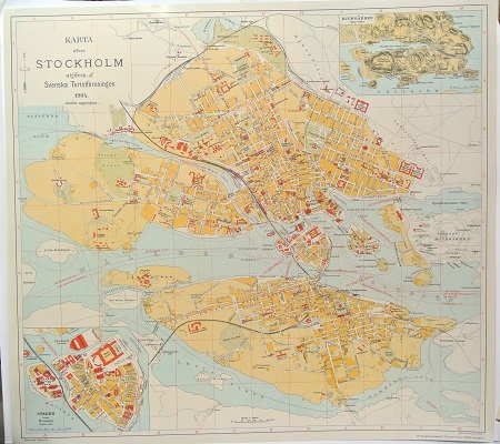
Karta öfver Stockholm. - 1904.
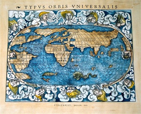
'Typus Orbis Universalis' - Ptolemaeus 1540.
