
1748-1804.
Kopparstickare, f. 1748 i Södermanland, d. 1804 i Stockholm, tillhörande släkten Achrelius (se d. o.). Under studenttiden i Upsala var han elev af globtillverkaren A. Åkerman, och 1773 gjorde han en studieresa till Paris, men måste redan följande år af brist på medel återvända till Sverige. Han blef 1776 gravör vid Vetenskaps-akademien och några år därefter föreståndare för Kosmografiska sällskapets globtillverkning samt ledamot af Konstakademien. Globtillverkning och kartritning voro A:s hufvuduppgifter, och hans i flere afseenden förbättrade glober funno god afsättning både inom och utom fäderneslandet. Dessutom utvecklade han Flodings manér att dels med stickeln, dels med torr nål underhjälpa etsningen, men hans arbeten förråda ofta ett handtverksmässigt utförande.
Bland arbeten.
Bland hans gravyrer märkas porträtt af Gustaf III, Ehrenstrahl, Stiernhielm, Linné och K. G. Tessin.
Nordisk Familjebok, Uggleupplagan.
GENERALSTABENS LITOGRAFISKA ANSTALT
Ursprungligen Generalstabens litografiska inrättning, bildades 1833 och ställdes under chefen för Lantförsvarsdepartementets kommandoexpedition såsom inspektör och fick till uppgift att utföra de litografiska arbeten, som erfordrades för nämnda expedition och för Topografiska kåren samt att bereda officerare tillfälle att få kunskaper om litografi.
Inrättningens personal bestod av kommenderade officerare och av civila tryckare. År 1872 uppläts anstalten genom kontrakt på 25 år till hovintendenten A. Börtzell. Staten lämnade lokal på Sergelgatan 1 i Stockholm. Föreståndaren för anstalten förband sig att utföra litografiska arbeten för allmänna verk och inrättningar mot vanligt gällande pris, att följa litografins och kartografins framsteg, att lämna undervisning i dessa ämnen åt Generalstabens personal, att vid fälttjänstövningar ställa erforderlig personal till krigsstyrelsens förfogande och att i händelse av krig överlämna hela anstalten till krigsstyrelsen mot gottgörelse. GLA hade fram till 1962 ensamrä...
1758-1829. Född och död i Köpenhamn.
Dansk sjöofficer. 1776 officer, 1789 kaptenlöjtnant, 1797 kapten och 1803 generalkrigskommissarie. Han deltog 1786 i Poul Lövenorns (se denne) expedition till Grönland, och beordrades 1787-1800 att leda arbetet med kartläggningen av den norska kusten från Tröndelag till Svinesund. Medlem av en rad sjömilitära kommissioner, Amiralitetskollegiet m.fl.
Bricka.
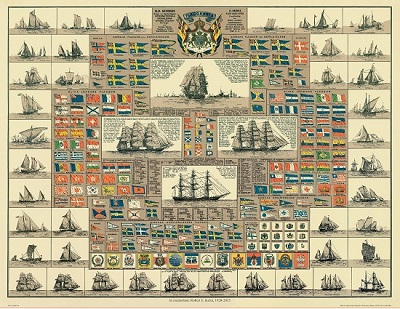
Amiral Häggs flaggkarta. - Stockholm 1888.
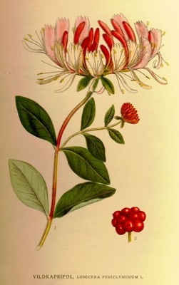
Vildkaprifol, Lonicera periclymenum - Lindman, C. A. M, Bilder ur Nordens Flora 1917-26.
