
1804-71. Född i Kirkhill, död i Yorkshire.
Skotsk kartograf. Han utmärkte sig som kartgravör och etablerade 1826 tillsammans med sin bror William Johnston (se denne) ett kartförlag i Edinburgh. Deras firma var väl ansedd och utgav under ĺrens lopp en rad stora och mindre atlaser, sĺväl generella som specialiserade, bl.a. historiska, fysiska och astronomiska atlaser. 1851 fick han medalj för en jordglob som visade den fysiska geografin, den första i sitt slag. Medlem av en rad geografiska sällskap i Storbritannien och andra länder. En av hans söner, med samma namn, förde verksamheten vidare.
Dict. nat. biogr.
PHILIPPE DE PRETOT, ÉTIENNE-ANDRÉ.
Ca. 1708-87. Född i London, död i Brighton.
Engelsk bokhandlare och förläggare. 1788 öppnade han i Leicester en bok- och pappershandel som snart blev ett centrum för revolutionär litteratur. Vid sidan om detta startade han 1792 en tidskrift, 'Leicester Herald', som han själv redigerade. 1795 flyttade han sin verksamhet till London och grundade där tidskriften 'Monthly Magazine' och flera andra skrifter. Hans förlagsverksamhet omfattade särskilt klassisk litteratur samt geografiska och naturvetenskapliga verk. 1807 blev han vald till sheriff av London.
Bland arbeten.
Leicester Herald.
Monthly Magazine.
Dict. nat. biogr.
1735-1813.
Lantmätare, verksam i Dalarna.
Bland arbeten.
Charta öfver Björnshytte masugnsvärks skog och inägor, med underliggande hemman och kolare torp, uti Stora Koppabergs höfdingedöme, Wästra Järnbergslagen och Grangärdes socken. Författad ĺren 1765, 1766, 1767 och 1772 af Nils Kiellström och Lars Henric Hilleström.
'Charta öfver Skommarbobys ägor. Författad ĺr 1773 af Nils Kiellström och Lars H. Hilleström'. (1 karta och 1 beskrivning).
Charta öfver Tvistige Rĺgĺngen Imellan Husby och Hedemora Soknar Uti Stora Kopparbergs Höfdingedöme Och Näsgĺrds Län Författad Ĺr 1773. af Ordinarie Landtmätaren Nils Kjellström och Commiss. Landtmät: L: H: Hilleström. Afritad i Kongel: General Landtmäteri Contoiret Ĺr 1776, af Jon: Brodin
Falun. Charta öfver Staden Falun och Stora Kopparbergs Grufwa. Författad Ĺren. 1780, 1781 och 1782 af L.H.Hilleström. Transporterad Ĺr 1800. Stora. Kopparbergslagets Respective Ledamöter i ödmjukhet tillegnad af Carl. Linderberg. Gravyr i färg. Tryckt ĺr 1800.
Kort beskrifning öfver staden Falun och Stora Kopparbergs grufvan, med bifogade kartor och vuer. Utgifven af Carl Linderberg ... Stockholm, tryckt hos Carl Delén, 1804.
'Charta öfwer Tuna Hästbergs Grufskog, Tillika med en ĺ Laxsjö sidan Pretenderad Skogstrand emot Tuna Socken, uti Stora Kopparbergs Höfdingedöme, Säthers Län. Och ofvannämde Socken belägne, Författad ĺr 1787 Af Lars Henric Hilleström'.
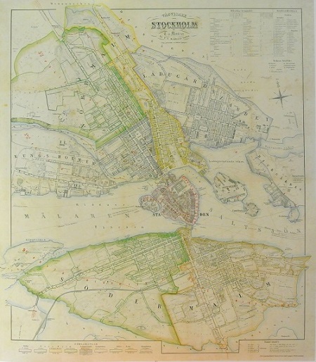
Stockholm - Mentzer ca 1860.
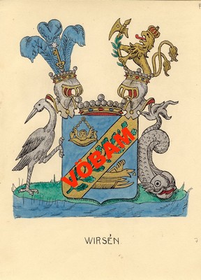
Wirsén - C. H. Tersmeden ca 1900.
Knight Leontiy Vassilievich Spafaryev (1765 - 30 January 1847) was a Lieutenant General of the Imperial Russian Navy. Spafaryev was Director of the Lighthouse Administration and cartographer of the Russian Admiralty.
Spafariev was an important contributor to the improvement of navigation along the Russian coasts. The first lighthouses in Russia were built during tsar Peter the Great's drive for reform and modernization at the beginning of the 18th century. However, it was only until the Administration of Lighthouses was created in 1807 that the Russian lighthouse system followed an organized pattern, becoming effective and efficient. This office was established by the Russian Navy and it began under the leadership of Leontiy V. Spafaryev.
As a cartographer, perhaps his most outstanding work is the 'Atlas of the Gulf of Finland', published in 1817. His name is spelt as 'Spafarief' or 'Spafarieff' in the United States.
The Spafaryev Islands in the Sea of Okhotsk and Spafarief Bay in the coast of Alaska were named after Leontiy V. Spafaryev.
Utgav i S:t Petersburg 'Atlas of the Gulf of Finland containing the South Coast, with the Islands from cape Luserort to Cronstadt with Light houses & Towers necessary to be known for sailing by night'. Denna atlas innehĺller 12 större kartor varav flera utvikbara. Stor folio.
Bland arbeten:
Atlas of the Gulf of Finland containing the South Coast, with the Islands from cape Luserort to Cronstadt with Light houses & Towers necessary to be known for sailing by night.
- Se bild.
