
Se GERRITSZ.
Tooley.
Holländsk bok- och karthandlare i början av 1700-talet. 1721 ingick han kompanjonskap med Cornelius Mortier (se denne) och fortsatte under firmanamnet Cóvens et Mortier Pieter Mortiers (se denne) affär i Amsterdam. Firman gav ut flera stora atlaser, i de flesta fallen sammansatta med kartor utförda av flera kartritare under en relativt lång tid. Förutom ett par odaterade verk kan nämnas 'Nouvel Atlas' (ca. 1735) och 'Nieuve Atlas' (1730-39). 1761 kom 'Atlas nouveau' med kartor så långt bak i tiden som 1683. Firman fanns kvar till 1817.
Bland arbeten.
Nouvel Atlas (ca. 1735).
Nieuve Atlas (1730-39).
'Atlas nouveau (1761).
Kleerkooper. Phillips.
Född 1782 25/12 i Stockholm, utbildad på Karlbergs krigsskola, fänrik vid Arméns Flotta 1798, avsked 1811 med löjtnants grad.
Johan Gustaf af Lund tillhörde en gammal soldatsläkt, Södermanlands regemente, där hans farfars far tjänstgjorde, hans farfar slogs vid Poltava och Bender, hans far såg strid i Pommerska kriget och adlades för medverkan i Gustav III:s kupp 1772. Han själv kom att tjänstgöra i Arméns flotta.
Johan Gustaf af Lund utförde ett antal aldrig utgivna kartor, bland annat den ovan nämnda kartan och kartor utförda under Finska kriget 1808-09.
Bland arbeten.
Manuskriptkarta över Bohuslän 1804.
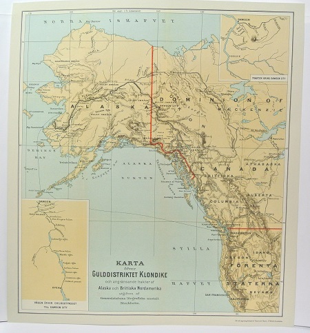
Gulddistriktet Klondike - ca 1897.
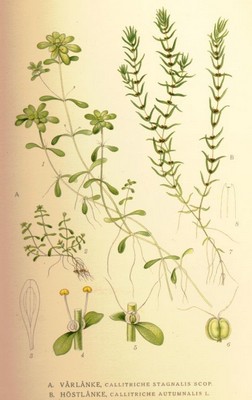
Vårlonke, Callitriche stagnalis - Lindman, C. A. M, Bilder ur Nordens Flora 1917-26.
