Mortier, Pieter [Pierre].
Biografiska uppgifter:1661-1711.
Boktryckare och bokhandlare i Amsterdam. Han omnämns första gĺngen 1679, och frĺn 1693 även som konsthandlare. 1690 fick han privilegium pĺ tryckning av Sansons (se denne) och Jaillots (se denne) kartor. 1693 övertog han en ny atlas av dessa och samma ĺr 'Le Neptune Francios' av Charles Pene, Cassini m.fl. Vidare kan nämnas 'Atlas nouveau des cartes geographiques choisies' (1703) och ett odaterat militärt kartverk, 'Les Forces de l'Europe, Asie, Afrique et Amerique'. Dĺ barnen ännu var omyndiga fortsatte änkan verksamheten till sin död 1719. 1721 fick sonen Cornelius Mortier (se nedan) i kompanjonskap med Johannes Cóvens överta verksamheten.
Pieter and David Mortier were brothers of French extraction whose publishing interests covered a wide field embracing French and English works as well as Dutch. Pieter was probably trained in the bookselling business in Paris and David spent many years in England; in fact, he acquired British nationality and died there in about 1728. After Pieter's death, his widow continued the business until their son, Cornelis, was able to take over; then, in 1721, Cornelis entered into partnership with his brother-in-law, Johannes Covens, to form the famous name Covens and Mortier, a firm which continued in being with slight change of name until the middle of the nineteenth century. For details of their publications see under Covens and Mortier.
Pieter (Pierre) Mortier (1661 - 1711) was a French cartographer, engraver, and print seller active in Amsterdam during
the later 17th and early 18th centuries.
The grandparents of Pieter Mortier were French refugees. Both Martijn de Mortier and his wife, Jenne de Lanoy, were
born at Bon or Bondy near Paris. They came to Leiden, when they married in 1625. They became a son Pieter. This son
Pieter married Anna Boot in Leiden in 1655. The family moved to Amsterdam in 1661 or 1662 after the birth of their
son Pieter, who became a bookseller.
Pieter Mortier was listed as a member of the booksellers guide on 27 august 1685. Being from French heritage, he had
more easy access to French cartographers such as De L'Isle, Sanson, Jaillot, de Fer and De Wit.
Consequently, much of Mortier's business was built upon leveraging the sophisticated Dutch printing establishment to
issue embellished high quality editions of previously contemporary French maps.
In the greater context of global cartography, this was a significant advantage as most Dutch map publishes had, at
this point, fallen into the miasma of reprinting their own outdated works.
By contrast, the cartographers of France were producing the most accurate and up to date charts anywhere.
Mortier's cartographic work culminated in the magnificent nautical atlas, Le Neptune Francois. Upon Pierre's death
in 1711 this business was inherited by his widow.
In 1721 his son Cornelius Mortier took over the day to day operation of the firm.
Cornelius partnered with his brother-in-law Jean Covens to form one of history's great cartographic
partnerships - Covens and Mortier - which continued to publish maps and atlases until about 1866.
Le Neptune françois
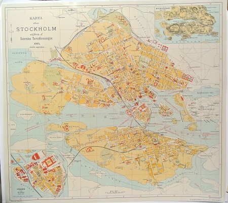
Le Neptune françois, the most beautiful nautical atlas published in Amsterdam in the seventeenth century, with the most eminent and reliable information, is a ‘contrefaçon’, a reproduction. Through its publication Pieter Mortier (1661-1711) wanted to compete with De Nieuwe Groote Lichtende Zeefakkel, the impressive pilot-guide that had established a monopoly for Johannes van Keulen (1654-1715) in the field of maritime cartography since 1681.
In the 1680s Jean Colbert (1619-1683) commissioned a group of mathematicians and astronomers of the Académie Royale des Sciences to map the coasts of the European continent from Norway to Gibraltar, together with hydrographers of the French Navy. This resulted in a magnificently engraved atlas of 29 leaves, which was printed in 1693 by the Imprimerie Royale in Paris. Publication was the responsibility of the royal geographer Alexis-Hubert Jaillot (1632-1712). In that very year Pieter Mortier's reproduction was published: engraved and printed in exactly the same way. Mortier was the son of a French political refugee, and had in 1690 been granted the privilege of distributing the maps and atlases of French publishers in Holland, a privilege he did, indeed, take full advantage of. As it was impossible for him to acquire the original copperplates, he had the charts newly engraved and subsequently put on the market under the original imprint. This was also the case with Le Neptune françois, of which he published no fewer than three different editions: in addition to the French edition there also appeared an English and a Dutch one. In that same year, 1693, Mortier published a second part, Cartes marines ŕ l'usage des armées du roy de la Grande Bretagne. This part, usually bound together with Le Neptune françois, contains nine large-size charts which, contrary to the first part, are not of French but of English origin. They were designed and engraved by Romeyn de Hooghe, then in the service of William III, the king-stadholder. These charts are among the highlights of Dutch seventeenth-century cartography.
Bland arbeten:
Le Neptune Francios.
Atlas nouveau des cartes geographiques choisies.
Les Forces de l'Europe, Asie, Afrique et Amerique.
(Kleerkooper. - Phillips.)
Tillbaka till början.