
1744-1808. Född i Osterburg i Altmark, död i Weimar.
Tysk kartograf. Arbetade som ingenjör och utförde därefter ett flertal mätarbeten i grevskapet Mark. Senare slog han sig ned i Weimar där han särskilt utmärkte sig med lantmätningsarbeten och kartritning. Större delen av hans kartor gavs ut av de Homanska arvingarna.
Conversations-Lexicon, Khb. 1818, b. IV - Phillips.
(fl. 1790-1812). Publisher at the sign of the Little Midshipman, later called Navigation Warehouse No. 157 Leadenhall Street. Joined by Williams 1768 [Heather & Williams] - up to 1800; succeeded by Norie 1812.
Bland arbeten.
Clements' Thames 1791, China Seas 1799, Pilot American Ocean 1795-1801, Harbours Brit. Channel 1801, New Mediterranean Pilot 1802, Andaman & Nicobar Is. 1803, New North Sea Pilot 1807, Marine Atlas 1808, North Amer. Pilot 1810, Pilot London Spain 1810, Pilot Brazils 1811, World 1812.
Tooley
Holländsk bokhandlarfirma, grundlagd i Amsterdam 1678 av Joannes van Keulen (se denne). Denne handlade med sjökort samt matematiska och nautiska böcker och instrument som han till viss del gjorde förarbetet till. Som förläggare gav han ut en rad stora sjökartverk som 'De lichtende Zeefaakkel' (1680-84), 'Zee Atlas' (1680) och 'De groote nieuwe vermeerderde Zee Atlas ofte water werelt' (1695). Dessa verk kom i flera nyutgĺvor. - Hans son, Gerard van Keulen, fortsatte verksamheten, reviderade de gamla kartorna och kompletterade med nya. Efter hans död 1726 fortsatte företaget under ledning av Johannes van Keulen d.y. (d. 1755). 1728 utkom en fransk utgĺva, 'Flambeau de la mer' i 4 band, och 1753 en reviderad utgĺva, 'De nieuwe groote lichtende Zee fakkel'. Frĺn 1779 var Gerard Hulst van Keulen (se denne) innehavare av företaget och ombesörjde flera nyutgĺvor av firmans atlaser. 1802 hade 'Zee-Fakkel' (med text pĺ holländska, franska och spanska) kommit ut i 26 utgĺvor, och 'Zee-Atlas' (utan text) i 15 utgĺvor....
Bland arbeten.
De lichtende Zeefaakkel.
Zee Atlas.
De groote nieuwe vermeerderde Zee Atlas ofte water werelt.
Flambeau de la mer.
De nieuwe groote lichtende Zee fakkel.
Nissen. - Nouv. biogr. gen. - Phillips. - Wieder.
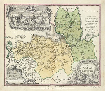
Ingermanlandiae – Homanns Erben 1734
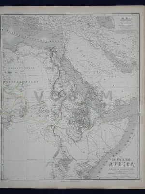
'Das Nordöstliche Africa' - Adolf Gräf och G. Lejean ca 1860.
