
Ca. 1755-1836.
Engelsk kopparstickare och kartförläggare. Redan som ung var han en erkänt duktig kopparstickare och fick flera gĺnger pris för sina arbeten. Han arbetade speciellt med mezzotintotekniken och uppfann en metod för att utföra mezzotintotryck i färg. För det fick han ett fint pris av Society of Arts 1776. 1794 ingick han kompanjonskap med James Whittle (se denne) och övertog Robert Sayers (se denne) konsthandel och kartförlag. Laurie övergav dĺ sin verksamhet som utförande konstnär, och gick helt upp i sina nya uppgifter. 1812 drog han sig tillbaka och överlät sin plats i firman till sonen Richard Holmes Laurie. Firman gav ut en rad större atlaser.
Dict. nat. biogr.
Lantmätare. Det blev först under 1670-talet som riksrĺden i Stockholm blev ordentligt medvetna om nödvändigheten av en genomgripande kartläggning utförd av lantmätare i de erövrade Östersjöprovinserna. Denna hade dittills skötts utifrĺn Riga. Men 1678 inrättades ett kontor i Narva. Genom att det delade lokalitet med fortifikationskĺren, kom karteringen av hela omrĺdet kring Finska vikens inre mot Ladoga att ske blandat civilt och militärt. Resultatet av denna gemensamma ansträngning blev en stor karta över Kexholms län - Ingermanland, som i dess slutliga, av lantmätaren A. Andersin renritade, skepnad visades pĺ utställningen genom Kungl. Bibliotekets försorg. Denna karta frĺn 1699 lät tsar Peter snabbt överföra till kopparstick av Adriaan Schoonebeck 1704.
Bland arbeten.
Karta Kexholms län - Ingermanland.
Kart & Bildteknik 2003:3, artikel Frĺn Nyen till Hiddensee. Svensk kartläggning under 1600-talet. Av Ulla Ehrensvärd.
Lantmätare. 'Till ĺr 1995 passade Riksarkivet (Latvijas Valsts vestures arhivs) i Riga pĺ att ge ut en väggkalender med tolv vägkartor, som lantmätaren A. A. Ulrichs sammanställt 300 ĺr tidigare'.
Kart & Bildteknik 2003:3, artikel "Frĺn Nyen till Hiddensee. Svensk kartläggning under 1600-talet". Av Ulla Ehrensvärd.
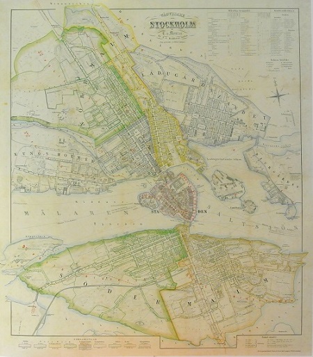
Stockholm - Mentzer ca 1860.
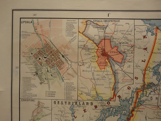
Upland och Södertörn - J. M. Larsson 1885.
BLAEU, WILLEM JANSZOON (Guilielmus Janssonius).
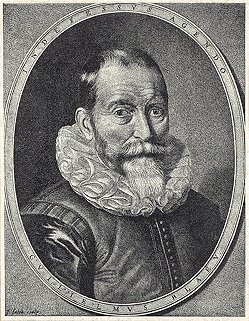
Biografiska uppgifter:1571-1638. Född i Uitgeest vid Alkmaar, död i Amsterdam.
Holländsk kartograf. 1591 kom han till Ven som elev till Tycho Brahe. Förutom astronomi lärde han sig även att arbeta med matematiska instrument, glober och kartor. 1596 slog han sig ned i Amsterdam där han grundade en affär med kartor och nautiska instrument. 1605 gav han ut en stor världsatlas i 18 delar. Senare följde en rad specialkartor och 1617 ett verk med sjökort, 'Licht der Zee-vaert', som även kom med fransk och engelsk text. 1629 gav han ut sin första hela atlas med 54 kartor. Av dessa hade han övertagit de flesta frĺn Henr. Hondius. Under Willem Blaeus livstid följde fyra nyutgĺvor, kompletterade med nya kartor. Verket fördes senare vidare av hans söner. Familjen Blaeus verksamhet spände över alla delar inom geografi, kosmografi, hydrografi, topografi etc. Firmans produktion är känd som sin tids yppersta kartografiska arbeten, och räknas dessutom till de vackraste kartarbeten som överhuvudtaget utförts.
Willem Blaeu förväxlas ibland med Jan Jansson (Johan Janssonius). Oftast gäller detta kartor producerade innan 1619 dĺ Blaeu signerade sina verk Guilielmus Janssonius eller Willems Jans Zoon. Saken görs inte bättre av att Jansson anklagades för att kopiera Blaeus kartor. Senare gick Blaeu över till att skriva Guilielmus eller G. Blaeu. (BL)
Bland arbeten:
Licht der Zee-vaert.
(Nederl. biogr. , X. - Richter. - Tooley.) - Se bild.
