
1648-1709?.
Holländsk kartförläggare. Född och död i Amsterdam där han drev en omfattande konst- och kartaffär. 1699 sökte han privilegium för utgivningen av en ny 'Atlas Minor' och 1706 gav han samtidigt ut bĺde en 'Atlas Minor' som innehöll 521 av den tidens bästa landskartor, och tvĺ mindre atlaser med uppskattningsvis 25 kartor. Frĺn 1708 finns bevarat en förteckning över hans samling av kopparstick, som ger ett bra bild av hans verksamhet. Förutom kartorna finner vi här en rad med prospekt och skeppskonstruktioner, porträtt och bilder med historiska och bibliska motiv. Flera av tidens främsta konstnärer finns representerade, däribland Rembrandt med 6 mĺlningar.
Bland arbeten.
Atlas Minor.
Kleerkooper.
Död 1771.
Engelsk geograf och kartograf. Han var en duktig landskapsmĺlare och kopparstickare som etablerade ett kartförlag i London och gav ut en rad specialkartor och atlaser över engelska omrĺden, Amerika, Västindien etc. Han gav även ut en rad geografiska verk och fick titeln 'Geographer to the King' (George III). Han intresserade sig framförallt för amerikanska farvatten, och sysselsatte sig bl.a. med 'The Great Probability of a North-West Passage' (1768). Efter hans död utkom 1775 ett stort sjökartverk: 'The North American Pilot', utgiven under tillsyn av den berömde upptäcktsresanden, kapten James Cook.
Bland arbeten.
The Great Probability of a North-West Passage.
The North American Pilot.
Dict. nat. biogr.
PTOLEMAIOS, CLAUDIUS (Ptolemaeus / Ptolemy).
Ca. 150 e. Kr.
Den äldre tidens mest berömda astronom, geograf och matematiker. Hans astronomiska teorier var ledande under 14 ĺrhundraden, och hans främsta verk, 'Syntaxis' eller 'Almagest', avlöstes inte förrän Newtons banbrytande forskning. Hans 'Geographia' dominerade hela den kristna och muhammedanska världen under 1500 ĺr. Det var Ptolemaeus som införde begreppen längd- och breddgrader, det system som geografin sedan dess följt i alla tider. Efter uppfinningen av boktryckerikonsten kom hans främsta geografiska verk helt eller delvis ut i en rad utgĺvor, som oftast kompletterades med senare forskningsresultat och nyare kartritningar. Till ĺr 1700 hade 45 utgĺvor pĺ mĺnga olika sprĺk utgivits. Sedan dess har ytterligare 7 utgĺvor tillkommit, den senaste ĺr 1883.
The 1482 edition of the Cosmographia, printed in Ulm, is one of the finest and most ambitious productions of the fifteenth century and the first printed atlas to include a corpus of “modern maps” as revised and supplemented by the important renaissance c...
Bland arbeten.
World. Untitled map of the world. Ulm: Leinhart Holle, 1482 or later. Prepared by Donnus Nicolas Germanus and cut by Johannes “Schnitzer”.
This world map is from the first edition of Ptolemy to be printed north of the Alps, and the first to use woodcut maps. It is the earliest surviving printed map signed by its engraver, and the first in the Ptolemaic sequence to include Scandinavia and to allude to lands beyond the confines of Ptolemy’s world view.
Salmonsen.- Tooley.
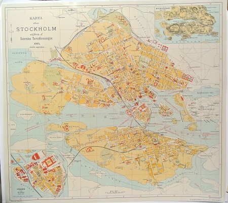
Karta öfver Stockholm. - 1904.
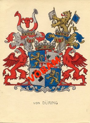
von Düring - C. H. Tersmeden ca 1900.
