
Carte de la Nouvelle Angleterre,...' - Bellin 1757.
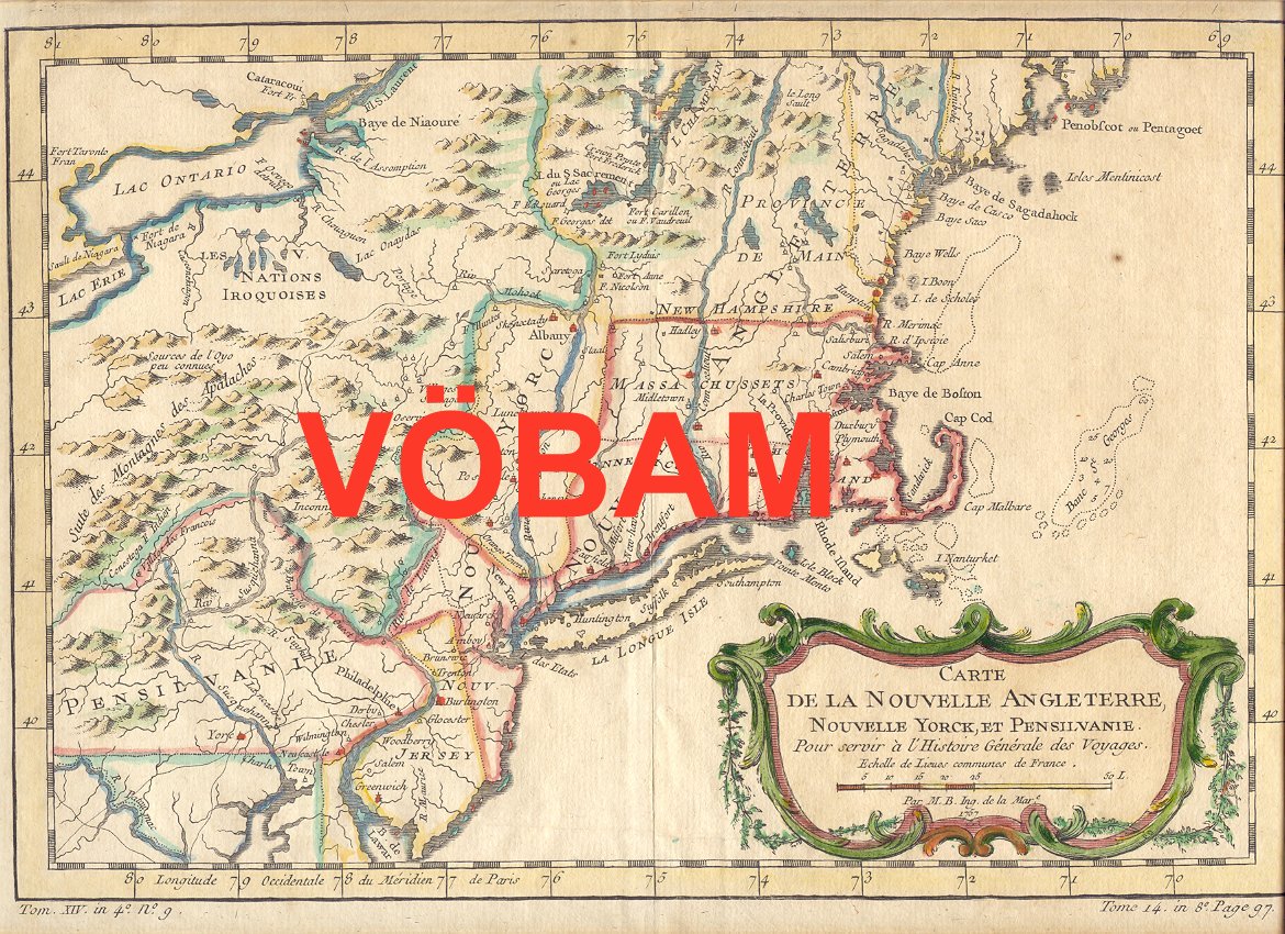
Carte de la Nouvelle Angleterre, Nouvelle Yorck, et Pensilvanie. Pour servir Ó l'Histoire Gķnķrale des Voyages.
Par M. B. Ing. de la Mare. 1757.
Koppargraverad karta med vacker handkolorering frÕn tiden.
Kartan har varit vikt, lite bruntonad i marginalerna.
Storlek: 29x20 cm. Kartytan bredden x h÷jden.
Pris: 2000 SEK - 26647 - Se bild.
'Geologic Atlas of the United States. Chattanooga Folio. Tennessee.' - Washington D.C. 1894.
Department of the Interior. United States Geological Survey. J. W. Powell, Director.
Washington D. C. Engraved and Printed by the U. S. Geological Survey. Bailey Willis, Editor of Geological maps. S. J. K³bel, Chief Engraver.
Flerfõrgslitografi.
Mapp med text pÕ insidan samt ytterligare fyra sidor text.
Fyra kartor, 'Topography', 'Areal Geology', 'Economic Geology', 'Structure Sections'.
En tabell, 'Columnar Sections'.
Storlek: 48x55 cm. Mappens bredd x h÷jd.
Pris: 600 SEK - 26658
Department of the Interior. United States Geological Survey. J. W. Powell, Director.
Washington D. C. Engraved and Printed by the U. S. Geological Survey. Bailey Willis, Editor of Geological maps. S. J. K³bel, Chief Engraver.
Flerfõrgslitografi.
Mapp med text pÕ insidan samt ytterligare fyra sidor text.
Fyra kartor, 'Topography', 'Areal Geology', 'Economic Geology', 'Structure Sections'.
Storlek: 48x55 cm. Mappens bredd x h÷jd.
Pris: 600 SEK - 26664
'Geologic Atlas of the United States. Sewanee Folio. Tennessee.' - Washington D.C. 1894.
Department of the Interior. United States Geological Survey. J. W. Powell, Director.
Washington D. C. Engraved and Printed by the U. S. Geological Survey. Bailey Willis, Editor of Geological maps. S. J. K³bel, Chief Engraver.
Flerfõrgslitografi.
Mapp med text pÕ insidan samt ytterligare fyra sidor text.
Fyra kartor, 'Topography', 'Areal Geology', 'Economic Geology', 'Structure Sections'.
En tabell, 'Columnar Sections'.
Storlek: 48x55 cm. Mappens bredd x h÷jd.
Pris: 600 SEK - 26656
Department of the Interior. United States Geological Survey. J. W. Powell, Director.
Washington D. C. Engraved and Printed by the U. S. Geological Survey. Bailey Willis, Editor of Geological maps. S. J. K³bel, Chief Engraver.
Flerfõrgslitografi.
Mapp med text pÕ insidan samt ytterligare sex sidor text.
Fyra kartor, 'Topography', 'Areal Geology', 'Economic Geology', 'Structure Sections'.
En tabell, 'Columnar Sections'.
Storlek: 48x55 cm. Mappens bredd x h÷jd.
Pris: 600 SEK - 26660
'Habits et Maisons des Floridiens.' - 1700-talets mitt.
Habits et Maisons des Floridiens.
Koppargraverad bild.
Storlek: 7x12 cm. Bildytans bredd x h÷jd.
Bild pÕ mõnniskor, hus och palmer i Florida.
Pris: 500 SEK - 26652
'Geologic Atlas of the United States. Sacramento Folio. California.' - Washington D.C. 1894.
Department of the Interior. United States Geological Survey. J. W. Powell, Director.
Washington D. C. Engraved and Printed by the U. S. Geological Survey. Bailey Willis, Editor of Geological maps. S. J. K³bel, Chief Engraver.
Flerfõrgslitografi.
Mapp med text pÕ insidan samt ytterligare fyra sidor text.
Fyra kartor, 'Topography', 'Areal Geology', 'Economic Geology', 'Structure Sections'.
Storlek: 48x55 cm. Mappens bredd x h÷jd.
Pris: 600 SEK - 26662
'Plan of the City of Washington.' - Ellicott 1792.
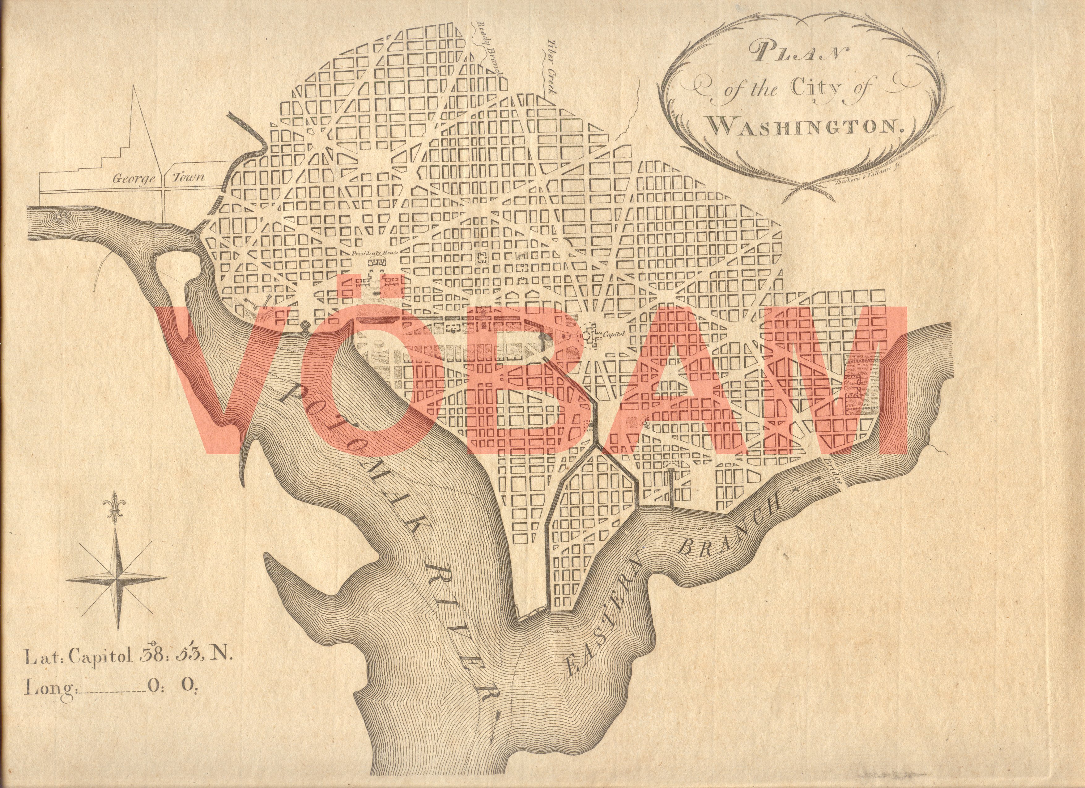
Plan of the City of Washington.
Tryckt i Philadelphia mars 1792 av Thackara och Vallance.
Storlek: 30x22 cm. KartplÕtens bredd x h÷jd. Breda marginaler.
Utomordentligt rar. / Very rare.
Karta ÷ver Washington.
Pris: 110000 SEK - 26649 - Se bild.
Denna karta lõt man trycka i f÷rsta hand f÷r att kunna visa var kvarter, markomrÕden o.s.v. i den nya huvudstaden lÕg f÷r de presumtiva k÷pare man sÕlde tomter till.
This map was printed primarily to show future buyers of building lots in the new capital where these lots actually was located in the city. It would take another couple of months until the first official city plan was published in november 1792 by Thackara and Vallance.
'Geologic Atlas of the United States. Kingston Folio. Tennessee.' - Washington D.C. 1894.
Department of the Interior. United States Geological Survey. J. W. Powell, Director.
Washington D. C. Engraved and Printed by the U. S. Geological Survey. Bailey Willis, Editor of Geological maps. S. J. K³bel, Chief Engraver.
Flerfõrgslitografi.
Mapp med text pÕ insidan samt ytterligare fyra sidor text.
Fyra kartor, 'Topography', 'Areal Geology', 'Economic Geology', 'Structure Sections'.
En tabell, 'Columnar Sections'.
Storlek: 48x55 cm. Mappens bredd x h÷jd.
Pris: 600 SEK - 26657
USA. - 1903-1913. - ur Le Petit Journal.
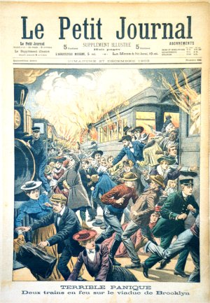
USA
4 f÷rsta-sidor 1903-1913 och 6 supplement-sidor utan Õrtal.
Totalt 10 motiv.
Storlek: 30x42 cm. Omvõxlande stÕende och liggande.
Pris: 2000 SEK - 26655 - Se bild.
Le Petit Journal, morgontidning i Paris och lõnge en av de 'fyra stora'. Grundad 1863. PÕ 1930-talet nationalistiskt eldkorsorgan. Tidningen upph÷rde i samband med andra võrldskriget.
Bilderna/motiven õr klart kitschiga och det õr just pÕ grund av detta som de blir mer och mer efters÷kta.
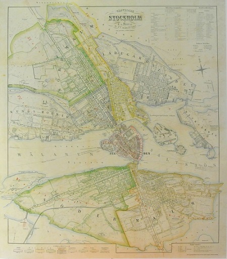
Stockholm - Mentzer ca 1860.
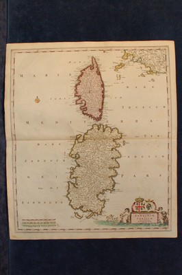
'Insularum Sardiniae et Corsicae' - Frederick de Wit, Pieter Mortier ca 1710.
Nya Sverige. - P. Lindstr÷m, T. Campanius Holm 1655.
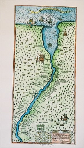
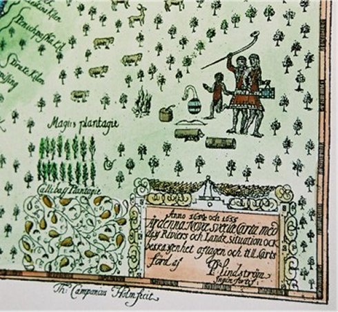

Nova Svecia hodie dicta Pennsylvania.
Anno 1654 och 1655 õr denna Nove Svecie charta med dess Riviers och Landz situation ock beskaffenhet aftagen och till Carts f÷rd af P. Lindstr÷m ingin. fortif..
Originalet frÕn Thomas Campanius Holms bok, 1702.
Faksimil pÕ akvarellpapper och helt handkolorerad.
Uppf÷rstorad: 25x55 cm. Pris: 1.200:-
Originalstorlek: 17x36,5 cm. Pris: 900:-
Pris: 900 SEK - 26645 - Se bild.
Amerika - Nordamerika - USA - Delaware, Pennsylvania, New Jersey, Maryland
