
'Carte géologique internationale de l'Europe.' - Berlin 1881-1913.
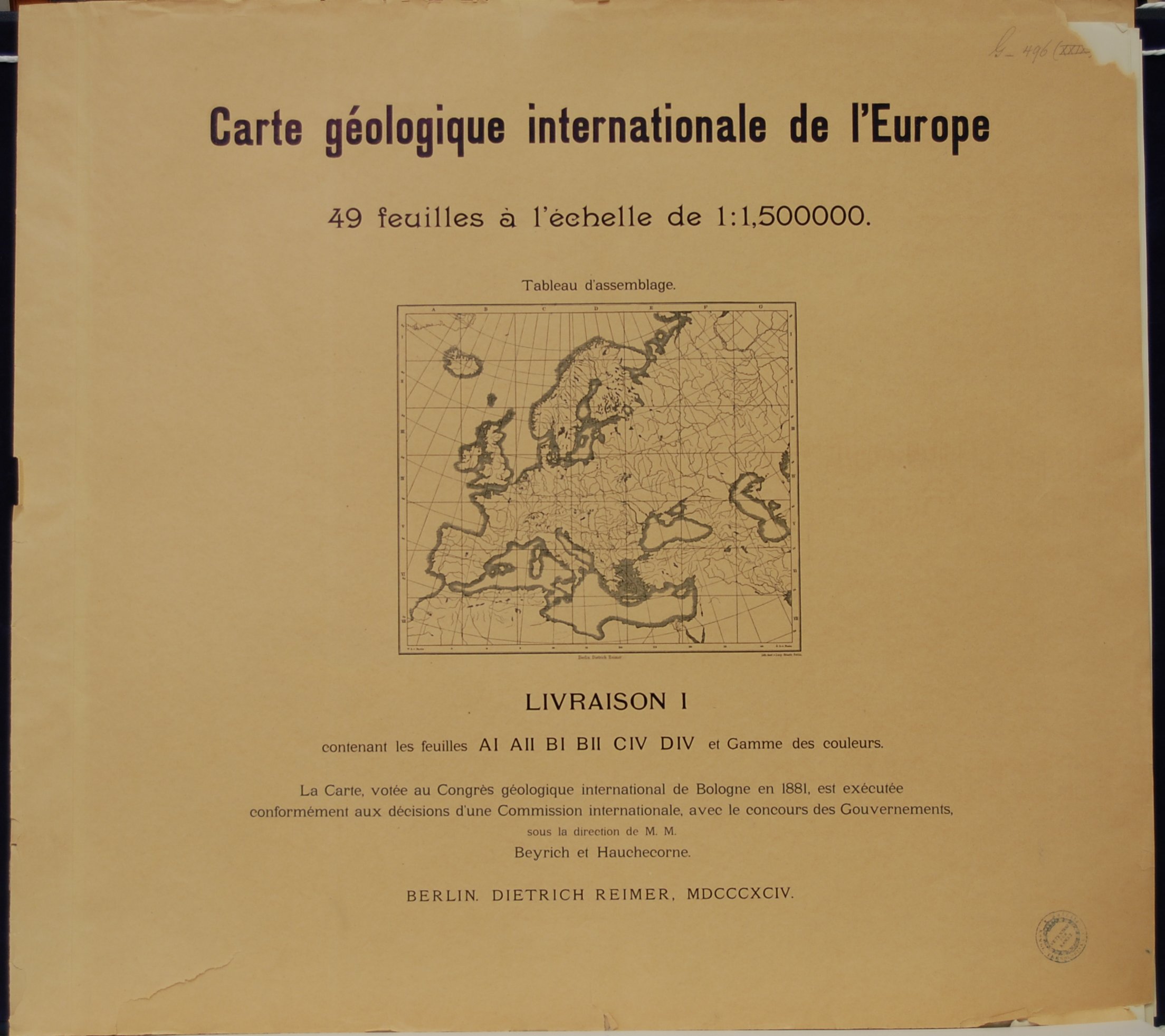
Carte géologique internationale de l'Europe.
Echelle 1:1,500,00.
La Carte, votée au Congrès géologique internationale de Bologne en 1881, est publiée conformément aux décisions d'une Commission internationale composée de M.M.
Beyrich, Hauchecorne, Beyschlag pour l'Allemagne,
Karpinsky, Tschernyschew, Sederholm pour la Russie,
Daubrée, Michel-Lévy pour la France,
Capellini, Giordano, Pellati pour l'Italie,
Mojsisovics, Tietze, v.Lóczy pour l'Autriche-Hongrie,
A.Geikie pour la Grande Bretagne,
Renevier, Schmidt pour la Suisse.
Elaboration et édition commencée sous la direction de M.M. Beyrich et Hauchecorne, exécutée et achevée par Beyschlag.
Dressée dans le bureau du Service Géologique de Prusse par M. Pütz.
Parue chez Dietrich Reimer Berlin 1881-1913.
Imprimée dans l'Institut lithographique de Berlin W.35.
Kromolitograferad geologisk karta över Europa i 47 blad plus 1 titelblad samt 1 teckenförklaringsblad liggandes i 8 originalomslag.
Första upplagan.
Skala: 1:1.500.000
Storlek per blad: 55x49 cm. Kartytans bredd x höjd.
Mycket fint skick. Ett antal blad med smärre skador i marginalen. Enstaka blad med stämpel i marginalen från 'Kongl. Teknologiska Institutet', vissa omslag med samma stämpel.
Pris: 6000 SEK - 26254 - Se bild.
Ett mycket fint set av denna fantastiska geologiska karta över Europa från sekelskiftet 1800-1900. Kartan är en av de viktigaste geologiska kartorna över Europa och ett vittnesbörd om samarbetet inom vetenskapen i Europa vid denna tid, innan de förödande världskrigen
Rönn, Sorbus aucuparia - Lindman, C. A. M, Bilder ur Nordens Flora 1917-26.
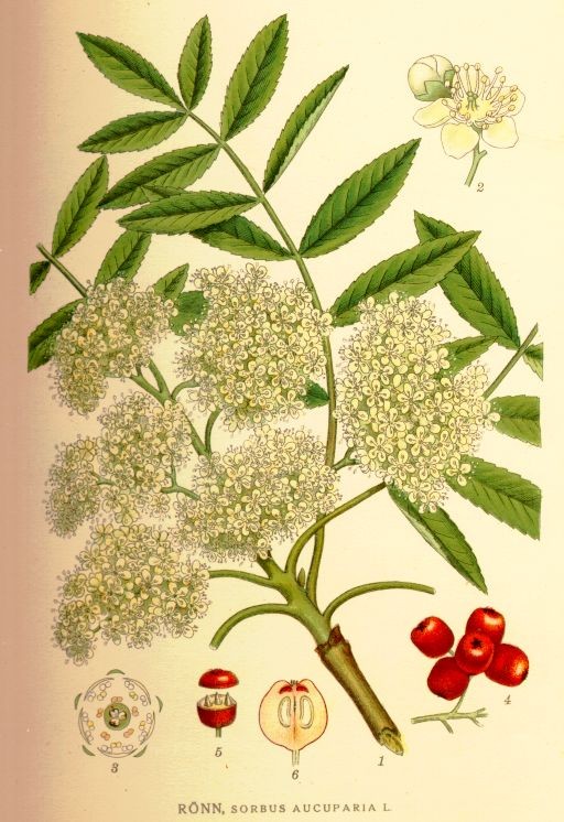
Rönn, Sorbus aucuparia
Bilder ur Nordens Flora.
Tredje upplagan 1917-1926.
VÖBAM har samtliga 663 planscher ur C. A. M. Lindmans 'Bilder ur Nordens Flora', 1917-1926.
Planschstorlek ca 15 x 20 cm.
Pris: 100 SEK - 40735 - Se bild.
'Regni Hungariae...' - L. Euler 1760.
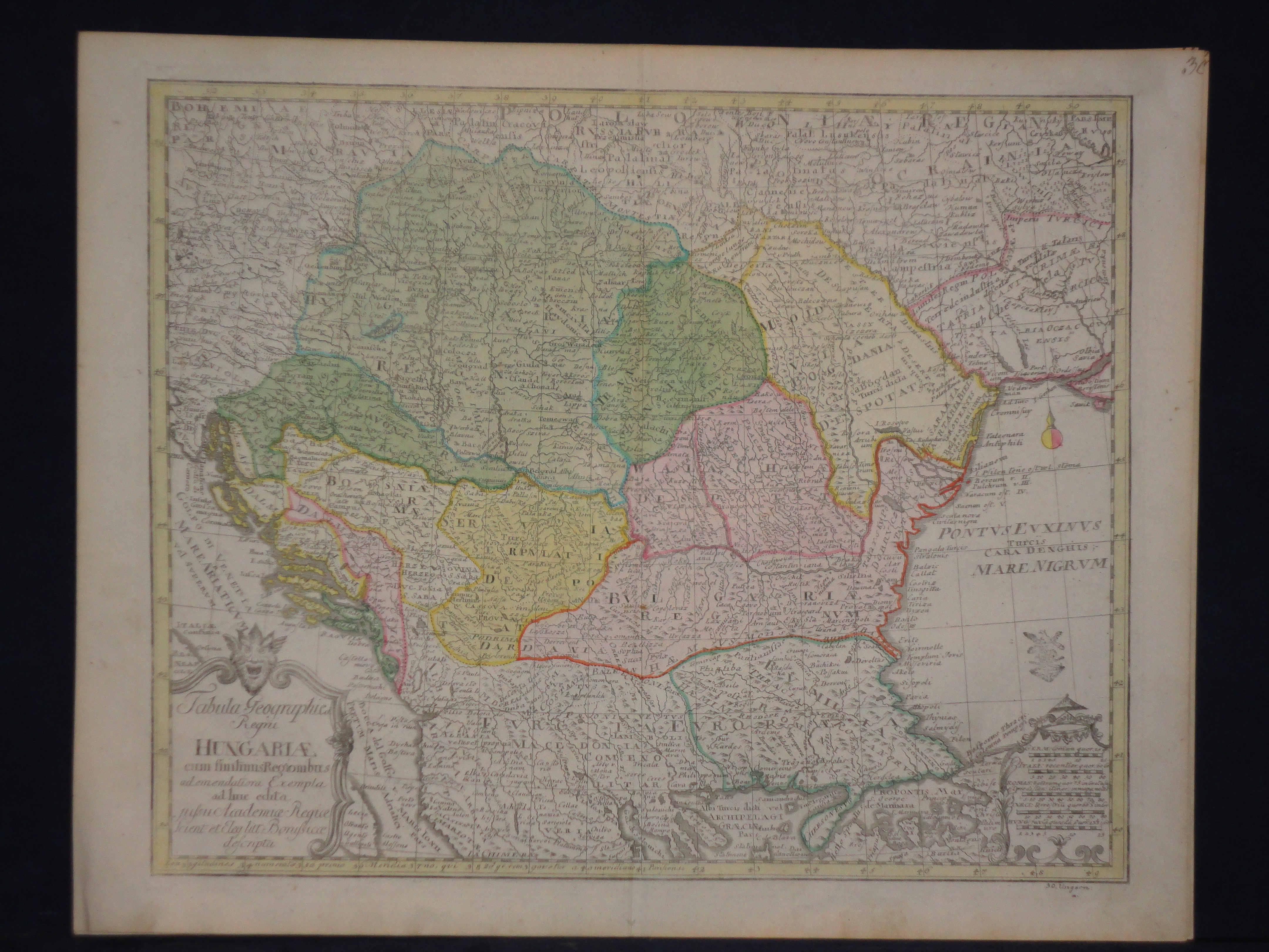
Tabula Geographie Regni Hungariae cum finitimis Regionibus ad emendatiora Exempla adhuc edita jussu Academiae Regiae Scient: et Eleg: Litt: Borussicae descripta.
Koppargraverad och originalkolorerad karta.
Kartan ur 'Geographischer Atlas' utgiven i Berlin 1760.
Mittveck, helt och rent exemplar av denna rara karta.
Stämplad med den preussiska skatte-, privilegiestämpeln i högra nedre hörnet.
Storlek: 40x32 cm, kartytans bredd x höjd.
Karta över Ungern, forna Jugoslavien, Rumänien, Bulgarien samt norra Grekland, Trakien och del av sydvästra Ukraina.
Pris: 3500 SEK - 27040 - Se bild.
Murruta, Asplenium ruta muraria - Lindman, C. A. M, Bilder ur Nordens Flora 1917-26.
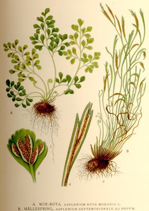
Murruta, Asplenium ruta muraria
Bilder ur Nordens Flora.
Tredje upplagan 1917-1926.
VÖBAM har samtliga 663 planscher ur C. A. M. Lindmans 'Bilder ur Nordens Flora', 1917-1926.
Planschstorlek ca 15 x 20 cm.
Pris: 100 SEK - 41199 - Se bild.
Mjukplister, Lamium Amplexicaule L. - Lindman, C. A. M, Bilder ur Nordens Flora 1917-26.
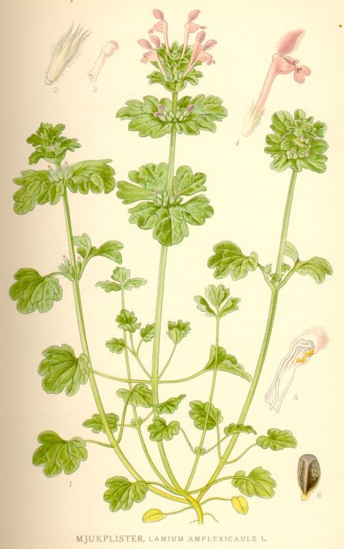
Mjukplister, Lamium Amplexicaule L.
Bilder ur Nordens Flora.
Tredje upplagan 1917-1926.
VÖBAM har samtliga 663 planscher ur C. A. M. Lindmans 'Bilder ur Nordens Flora', 1917-1926.
Planschstorlek ca 15 x 20 cm.
Pris: 100 SEK - 41023 - Se bild.
39. Griffenfeld, Peder H, rikskansler, greve. - 1912.
39. Griffenfeld, Peder H, rikskansler, greve.
Miniatyrporträtt utfört i Berlin år 1912 i vackert akvarelltryck.
Oval. 7 x 9
Måttet anger bredden x höjden i cm = bildytan.
Pris: 400 SEK - 38306
Dvärgvårlök, Gagea minima - Lindman, C. A. M, Bilder ur Nordens Flora 1917-26.
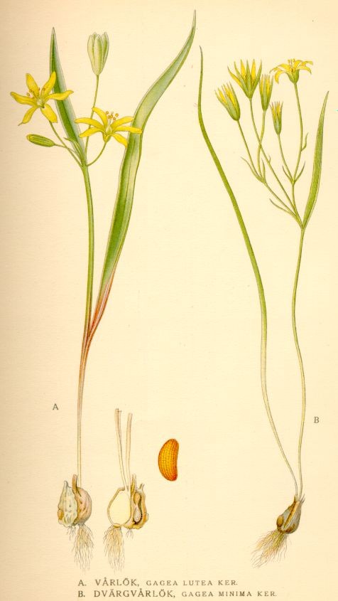
Dvärgvårlök, Gagea minima
Bilder ur Nordens Flora.
Tredje upplagan 1917-1926.
VÖBAM har samtliga 663 planscher ur C. A. M. Lindmans 'Bilder ur Nordens Flora', 1917-1926.
Planschstorlek ca 15 x 20 cm.
Pris: 100 SEK - 40836 - Se bild.
Tuvtåtel, Deschampsia cæspitosa - Lindman, C. A. M, Bilder ur Nordens Flora 1917-26.
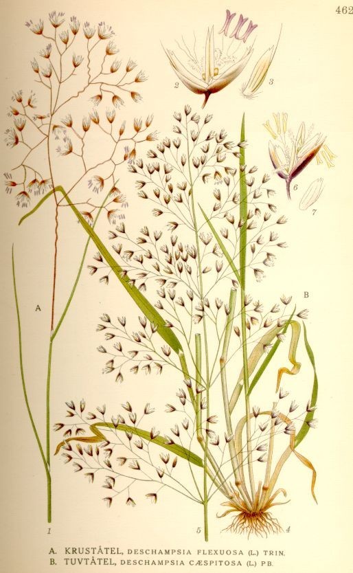
Tuvtåtel, Deschampsia cæspitosa
Bilder ur Nordens Flora.
Tredje upplagan 1917-1926.
VÖBAM har samtliga 663 planscher ur C. A. M. Lindmans 'Bilder ur Nordens Flora', 1917-1926.
Planschstorlek ca 15 x 20 cm.
Pris: 100 SEK - 41188 - Se bild.
'Novus Planiglobii Terrestris' - Joan Blaeu, Gerard Valck 1695.
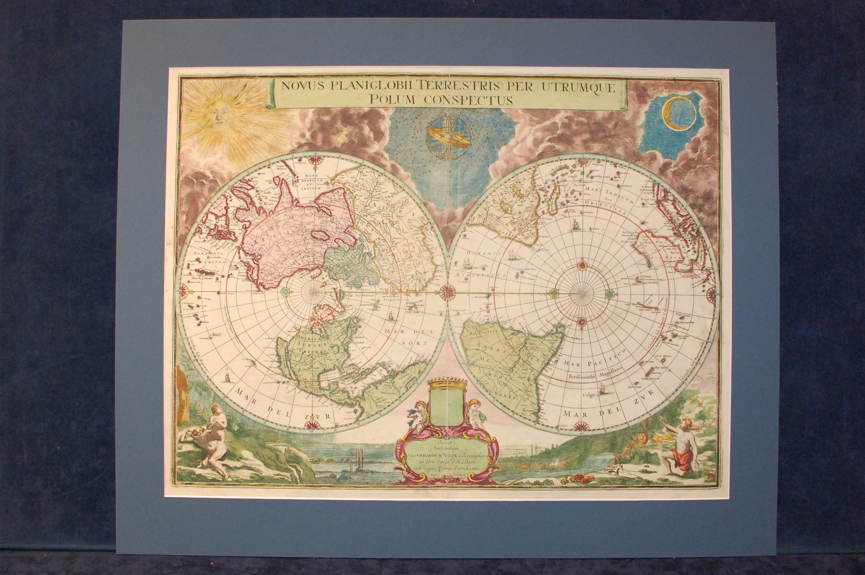
Novus Planiglobii Terrestris per Utrumque Polum Conspectus.
Prosat Amstelaedami Penes Gerardum Valck Calcographum in foro vulgo den Dam sub signo Canis Excubantis Cum Privilegio.
Copper engraved and handcoloured map with original colours.
The cartouche with the imprint bear marks of an earlier imprint by Blaeu, probably Joan Blaeu. Historians believe the plate to have been engraved in 1672, although some argue that the erased signature belongs to G. [Willem] Blaeu, deceased 1638.
The map was however never published by the Blaeu printing house, probably because of the devastating fire 1672 that destroyed much of the printing house and stock. The plate was later sold to Gerard Valck. After erasing the contents of the shield and the imprint in the cartouche, replacing it with his own name, Valck published the map as his own in 1695.
The map itself is composed of two hemispheres centred over the poles. The rest of the frame is filled with ornaments and pictorials. In the top left the sun surrounded with clouds, top center there is a armillary sphere / spherical astrolabe surrounded by stars, and in the top right corner the moon also surrounded with clouds.
Below the hemispheres in the right and left corner we find the garden of Eden with Adam and Eve. The right corner depicts Adam clothed in a sunny garden of Eden surrounded by animals. The left corner depicts Adam and Eve, naked in a deserted landscape under heavy rain, probably after they have been expelled from the garden of Eden. In between those two scenes we find the cartouche and a empty shield.
Size: ca 54x40 cm, width x height.
Repairs to the center fold. Mounted in non-acid passepartout.
The map shows California as an island; the only Blaeu map to depict this cartographic myth. In the Pacific, the coastline of Australia is beginning take shape. In South America, the mythical Parime Lacus is shown on the Equator, and the southern tip of the continent is oddly truncated due to the projection.
Pris: 50000 SEK - 39816 - Se bild.
Rare imprint of the last Blaeu world map.
Vårsallat, Valerianella olitoria - Lindman, C. A. M, Bilder ur Nordens Flora 1917-26.
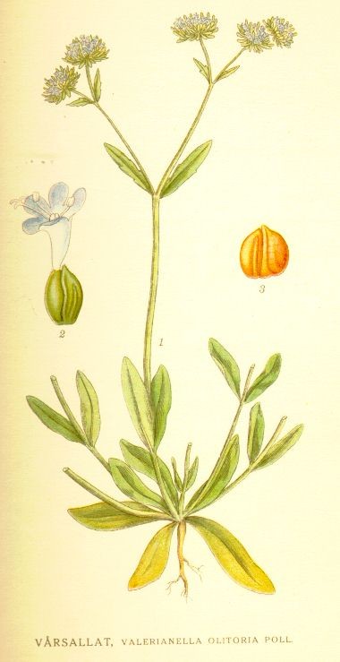
Vårsallat, Valerianella olitoria
Bilder ur Nordens Flora.
Tredje upplagan 1917-1926.
VÖBAM har samtliga 663 planscher ur C. A. M. Lindmans 'Bilder ur Nordens Flora', 1917-1926.
Planschstorlek ca 15 x 20 cm.
Pris: 100 SEK - 40512 - Se bild.

Vägvisare för XI Olympiaden i Berlin - 1936
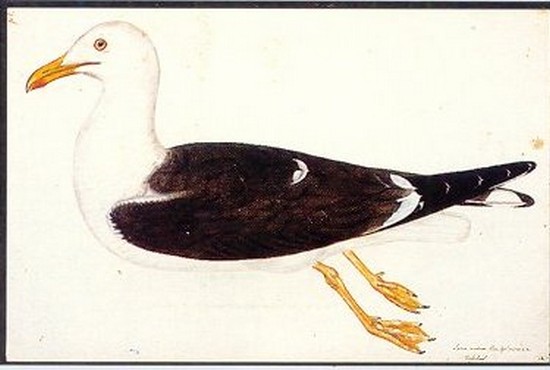
Silltrut - Olof Rudbeck d.y.
Vattenklöver, Menyanthes triofoliata - Lindman, C. A. M, Bilder ur Nordens Flora 1917-26.
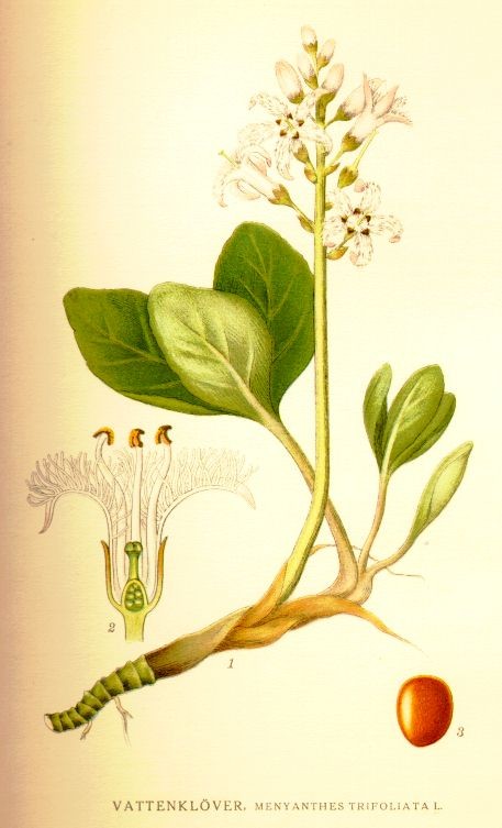
Vattenklöver, Menyanthes triofoliata
Bilder ur Nordens Flora.
Tredje upplagan 1917-1926.
VÖBAM har samtliga 663 planscher ur C. A. M. Lindmans 'Bilder ur Nordens Flora', 1917-1926.
Planschstorlek ca 15 x 20 cm.
Pris: 100 SEK - 40530 - Se bild.
Europa - Nordeuropa - -
