
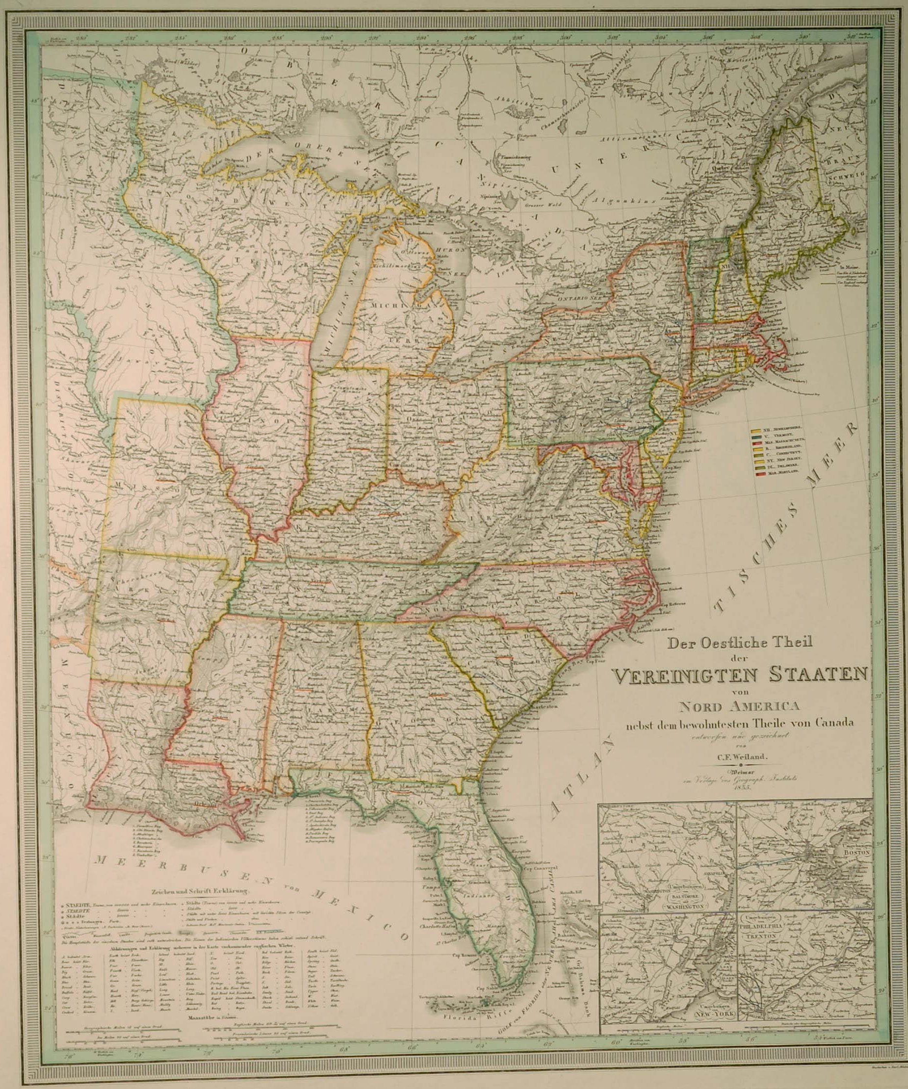
Der Oestliche Theil der VEREINIGTEN STAATEN von NORD AMERICA nebst dem bewohntesten Theile von Canada.
Entworfen und gezeichnet von C. F. Weiland.
Skala: 1:5.140.000
Infällda kartor: 'Umgebungen von Baltimore und Washington.', 'Umgebungen von Boston.', 'Umgebungen von New-York.', 'Umgebungen von Philadelphia und Trenton.'
Weimar 1835. Verlage des Geograph. Instituts.
Storlek: 50x59 cm.
Kraftfull gränskolorering.
Pris: 4500 SEK - 26076 - Se bild.
'Geologic Atlas of the United States. Livingstone Folio. Montana.' - Washington D.C. 1894.
Department of the Interior. United States Geological Survey. J. W. Powell, Director.
Washington D. C. Engraved and Printed by the U. S. Geological Survey. Bailey Willis, Editor of Geological maps. S. J. Kübel, Chief Engraver.
Flerfärgslitografi.
Mapp med text på insidan samt ytterligare fyra sidor text.
Fyra kartor, 'Topography', 'Areal Geology', 'Economic Geology', 'Structure Sections'.
Storlek: 48x55 cm. Mappens bredd x höjd.
Pris: 600 SEK - 26665
'New Map of Boston...' - 1883.
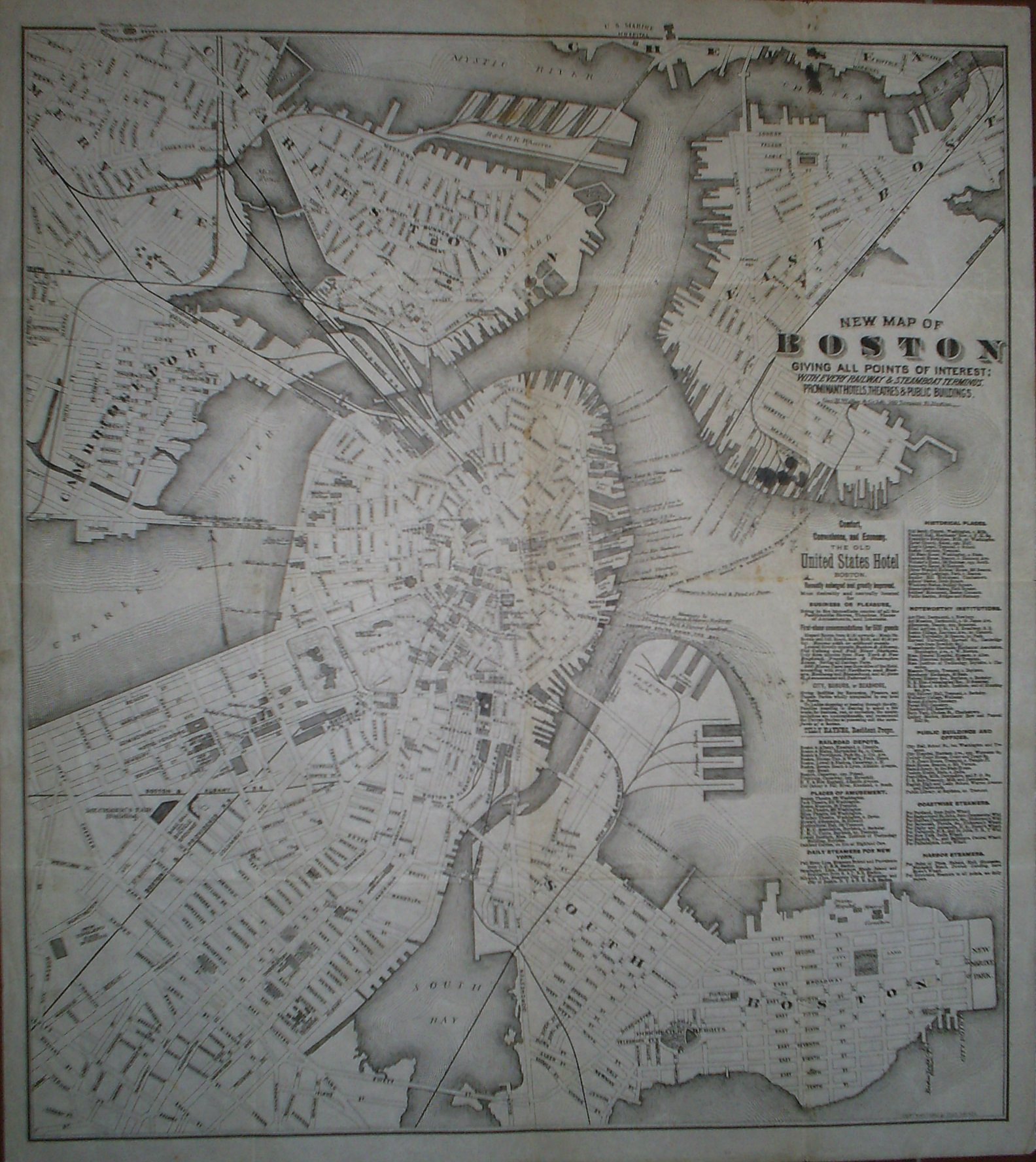
New Map of Boston giving all points of interest: with every railway & steamboat terminus, prominant hotels, theatres & public buildings.
Geo. H. Walker & Co Lith. 160 Tremont St. Boston.
Copyright 1883 by Tilly Haynes.
Litograferad karta.
Storlek: 44x49 cm. Kartytans bredd x höjd.
Kartan har varit vikt. Med småhål i vikningen. Fyra smärre bläckfläckar under titeln samt tre stycken i kartans övre kant. Svag bruntoning i mittvecket.
Karta över Boston.
Pris: 2000 SEK - 26650 - Se bild.
Med reklam för 'The Old United States Hotel Boston' samt lista över kommunikationer, sevärdheter, historiska platser med mera.
'Geologic Atlas of the United States. Kingston Folio. Tennessee.' - Washington D.C. 1894.
Department of the Interior. United States Geological Survey. J. W. Powell, Director.
Washington D. C. Engraved and Printed by the U. S. Geological Survey. Bailey Willis, Editor of Geological maps. S. J. Kübel, Chief Engraver.
Flerfärgslitografi.
Mapp med text på insidan samt ytterligare fyra sidor text.
Fyra kartor, 'Topography', 'Areal Geology', 'Economic Geology', 'Structure Sections'.
En tabell, 'Columnar Sections'.
Storlek: 48x55 cm. Mappens bredd x höjd.
Pris: 600 SEK - 26657
'Geologic Atlas of the United States. Ringgold Folio. Georgia - Tennessee.' - Washington D.C. 1894.
Department of the Interior. United States Geological Survey. J. W. Powell, Director.
Washington D. C. Engraved and Printed by the U. S. Geological Survey. Bailey Willis, Editor of Geological maps. S. J. Kübel, Chief Engraver.
Mapp med text på insidan samt ytterligare fyra sidor text.
Fyra kartor, 'Topography', 'Areal Geology', 'Economic Geology', 'Structure Sections'.
En tabell, 'Columnar Sections'.
Storlek: 48x55 cm. Mappens bredd x höjd.
Pris: 600 SEK - 26659
Department of the Interior. United States Geological Survey. J. W. Powell, Director.
Washington D. C. Engraved and Printed by the U. S. Geological Survey. Bailey Willis, Editor of Geological maps. S. J. Kübel, Chief Engraver.
Flerfärgslitografi.
Mapp med text på insidan samt ytterligare sex sidor text.
Fyra kartor, 'Topography', 'Areal Geology', 'Economic Geology', 'Structure Sections'.
En tabell, 'Columnar Sections'.
Storlek: 48x55 cm. Mappens bredd x höjd.
Pris: 600 SEK - 26660
Carte de la Nouvelle Angleterre,...' - Bellin 1757.
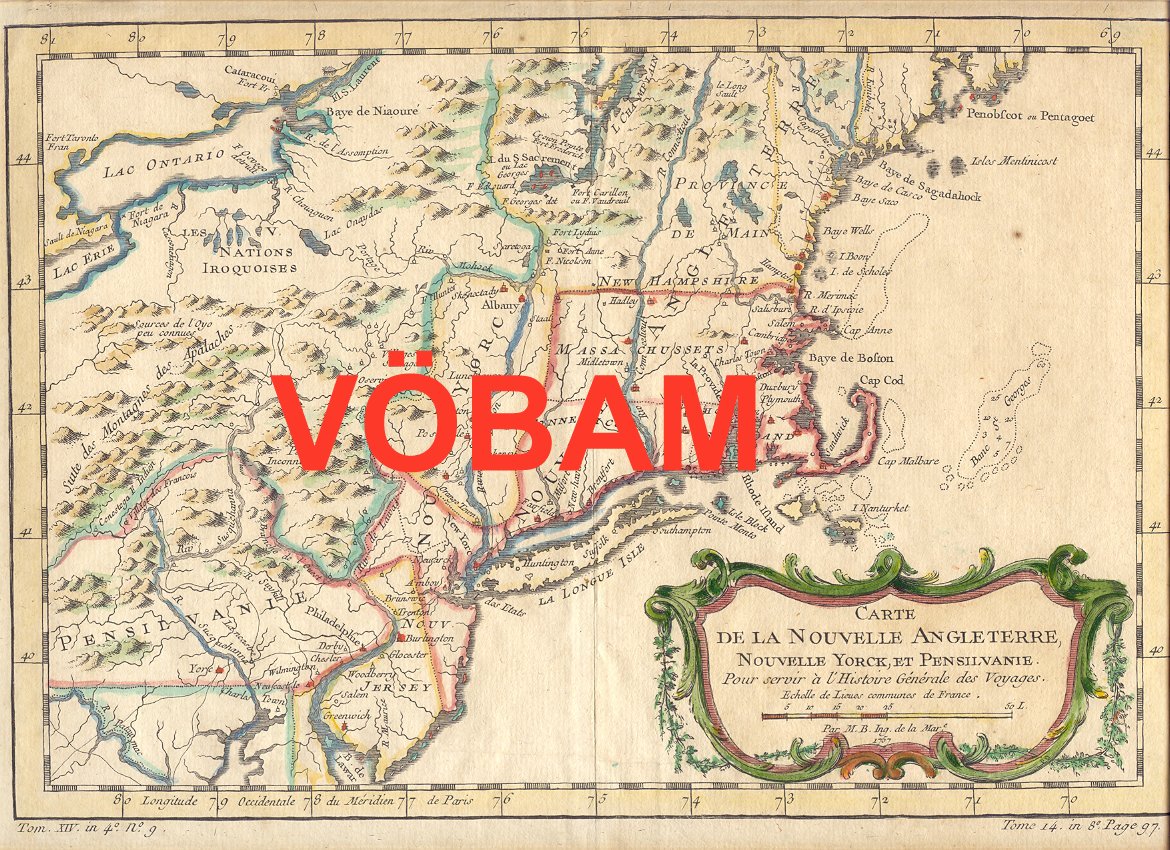
Carte de la Nouvelle Angleterre, Nouvelle Yorck, et Pensilvanie. Pour servir à l'Histoire Générale des Voyages.
Par M. B. Ing. de la Mare. 1757.
Koppargraverad karta med vacker handkolorering från tiden.
Kartan har varit vikt, lite bruntonad i marginalerna.
Storlek: 29x20 cm. Kartytan bredden x höjden.
Pris: 2000 SEK - 26647 - Se bild.
'Geologic Atlas of the United States. Sewanee Folio. Tennessee.' - Washington D.C. 1894.
Department of the Interior. United States Geological Survey. J. W. Powell, Director.
Washington D. C. Engraved and Printed by the U. S. Geological Survey. Bailey Willis, Editor of Geological maps. S. J. Kübel, Chief Engraver.
Flerfärgslitografi.
Mapp med text på insidan samt ytterligare fyra sidor text.
Fyra kartor, 'Topography', 'Areal Geology', 'Economic Geology', 'Structure Sections'.
En tabell, 'Columnar Sections'.
Storlek: 48x55 cm. Mappens bredd x höjd.
Pris: 600 SEK - 26656
'Geologic Atlas of the United States. Placerville Folio. California.' - Washington D.C. 1894.
Department of the Interior. United States Geological Survey. J. W. Powell, Director.
Washington D. C. Engraved and Printed by the U. S. Geological Survey. Bailey Willis, Editor of Geological maps. S. J. Kübel, Chief Engraver.
Flerfärgslitografi.
Mapp med text på insidan samt ytterligare fyra sidor text.
Fyra kartor, 'Topography', 'Areal Geology', 'Economic Geology', 'Structure Sections'.
Storlek: 48x55 cm. Mappens bredd x höjd.
Pris: 600 SEK - 26663
Boston - John William Hill, ca 1850.
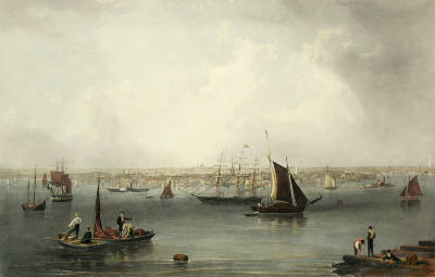
Boston
Gravyr tryckt från originalplåten och handkolorerad.
Storlek: 102x71 cm. Bildytans bredd x höjd.
En mycket dekorativ panoramavy över Boston och dess hamn från tiden före inbördeskriget.
Pris: 6000 SEK - 26654 - Se bild.
Pris med bred spansk vacker mahognyinspirerad ram: 9.000:-

Vägvisare för XI Olympiaden i Berlin - 1936
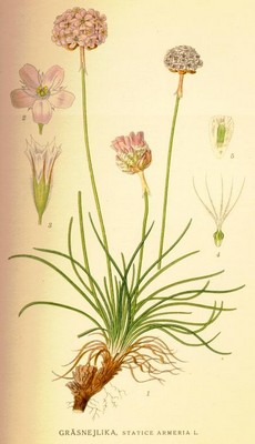
Gräsnejlika, Statice armeria - Lindman, C. A. M, Bilder ur Nordens Flora 1917-26.
New York - John William Hill, ca 1850.
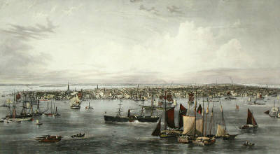
New York
Gravyr tryckt från originalplåten och handkolorerad.
Storlek: 142x89 cm. Bildytans bredd x höjd.
En mycket dekorativ panoramavy över Manhattan med East River i förgrunden och Hudsonfloden i bakgrunden.
Pris: 8000 SEK - 26653 - Se bild.
Amerika - Nordamerika - USA -
Pris med bred spansk vacker mahognyinspirerad ram: 15.000:-
