
Grĺbo, Artemisia vulgaris - Lindman, C. A. M, Bilder ur Nordens Flora 1917-26.

Grĺbo, Artemisia vulgaris
Bilder ur Nordens Flora.
Tredje upplagan 1917-1926.
VÖBAM har samtliga 663 planscher ur C. A. M. Lindmans 'Bilder ur Nordens Flora', 1917-1926.
Planschstorlek ca 15 x 20 cm.
Pris: 100 SEK - 40469 - Se bild.
'Carte des Royaumes de Congo, Angola et Benguela.' - 1700-talets mitt.
Carte des Royaumes de Congo, Angola et Benguela.
Koppargraverad karta.
Storlek: 32x24 cm. Kartytans bredd x höjd.
Kartan har varit vikt.
Karta över västra Afrikas kust frĺn Kap Lopez, Port Gentil, ner till gränsen mellan Angola och Namibia.
Pris: 2000 SEK - 26554
Grĺal, Alnus incana - Lindman, C. A. M, Bilder ur Nordens Flora 1917-26.
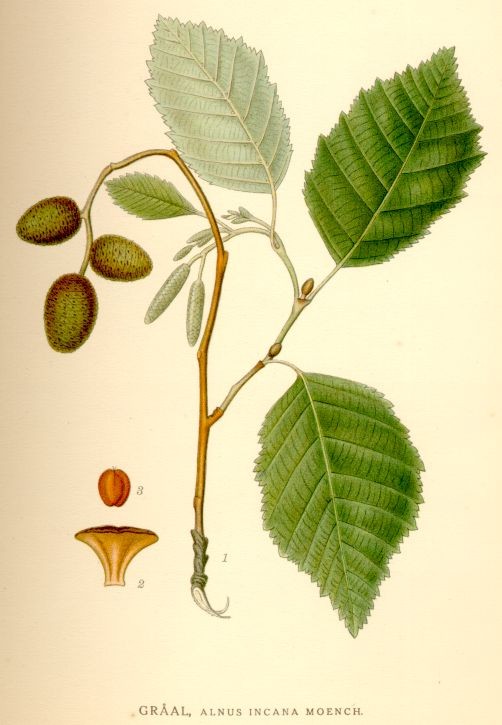
Grĺal, Alnus incana
Bilder ur Nordens Flora.
Tredje upplagan 1917-1926.
VÖBAM har samtliga 663 planscher ur C. A. M. Lindmans 'Bilder ur Nordens Flora', 1917-1926.
Planschstorlek ca 15 x 20 cm.
Pris: 100 SEK - 40825 - Se bild.
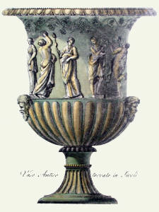
Green Vases, Pl. X
Gravyr tryckt frĺn originalplĺten och handkolorerad.
Storlek: 23x28 cm, plĺtytans bredd x höjd.
Pris pĺ förfrĺgan. - 40420 - Se bild.
Trolldruva, Actća spicata - Lindman, C. A. M, Bilder ur Nordens Flora 1917-26.
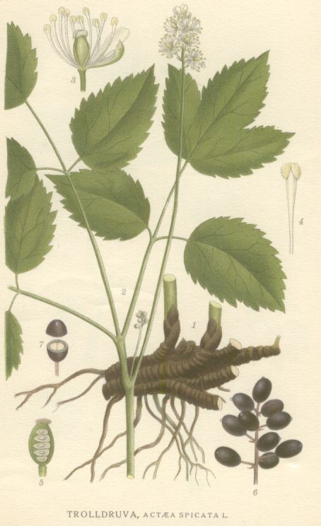
Trolldruva, Actća spicata
Bilder ur Nordens Flora.
Tredje upplagan 1917-1926.
VÖBAM har samtliga 663 planscher ur C. A. M. Lindmans 'Bilder ur Nordens Flora', 1917-1926.
Planschstorlek ca 15 x 20 cm.
Pris: 100 SEK - 40630 - Se bild.
Hönsbär, Cornus suecica - Lindman, C. A. M, Bilder ur Nordens Flora 1917-26.
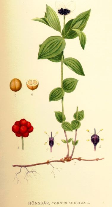
Hönsbär, Cornus suecica
Bilder ur Nordens Flora.
Tredje upplagan 1917-1926.
VÖBAM har samtliga 663 planscher ur C. A. M. Lindmans 'Bilder ur Nordens Flora', 1917-1926.
Planschstorlek ca 15 x 20 cm.
Pris: 100 SEK - 40699 - Se bild.
Dovremalört, Artemisia Norvegica Fr - Lindman, C. A. M, Bilder ur Nordens Flora 1917-26.

Dovremalört, Artemisia Norvegica Fr
Bilder ur Nordens Flora.
Tredje upplagan 1917-1926.
VÖBAM har samtliga 663 planscher ur C. A. M. Lindmans 'Bilder ur Nordens Flora', 1917-1926.
Planschstorlek ca 15 x 20 cm.
Pris: 100 SEK - 40987 - Se bild.
Smultronfingerört, Potentilla Sterilis (L.) Garcke
Bilder ur Nordens Flora.
Tredje upplagan 1917-1926.
VÖBAM har samtliga 663 planscher ur C. A. M. Lindmans 'Bilder ur Nordens Flora', 1917-1926.
Planschstorlek ca 15 x 20 cm.
Pris: 100 SEK - 41065
'Currents of the Air.' - A. Johnston 1850.
Geographical Distribution of the Currents of the Air or of the perennial, periodical and variable Winds. Showing also the various Regions of Prevalent Hurricanes.
Koppargraverad och handkolorerad karta ur 'A Series of Maps & Illustrations of the Geographical Distribution of Natural Phenomena embracing.' tryckt i London 1850.
Storlek: 57x47 cm. Kartytans bredd x höjd.
Textavsnitt medföljer.
Pris: 2000 SEK - 26268
97. Man – Gillberg, Jakob Axel. 1912.
Man
Miniatyrporträtt utfört i Berlin ĺr 1912 i vackert akvarelltryck.
Rund. 5,8 x 5,8
Mĺttet anger bredden x höjden i cm = bildytan.
Pris: 300 SEK - 38364
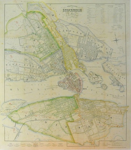
Stockholm - Mentzer ca 1860.

Landskrona / Ven-kartan 1860 och 1933.
Album Vilmorin 1865. - Elisa Champin.
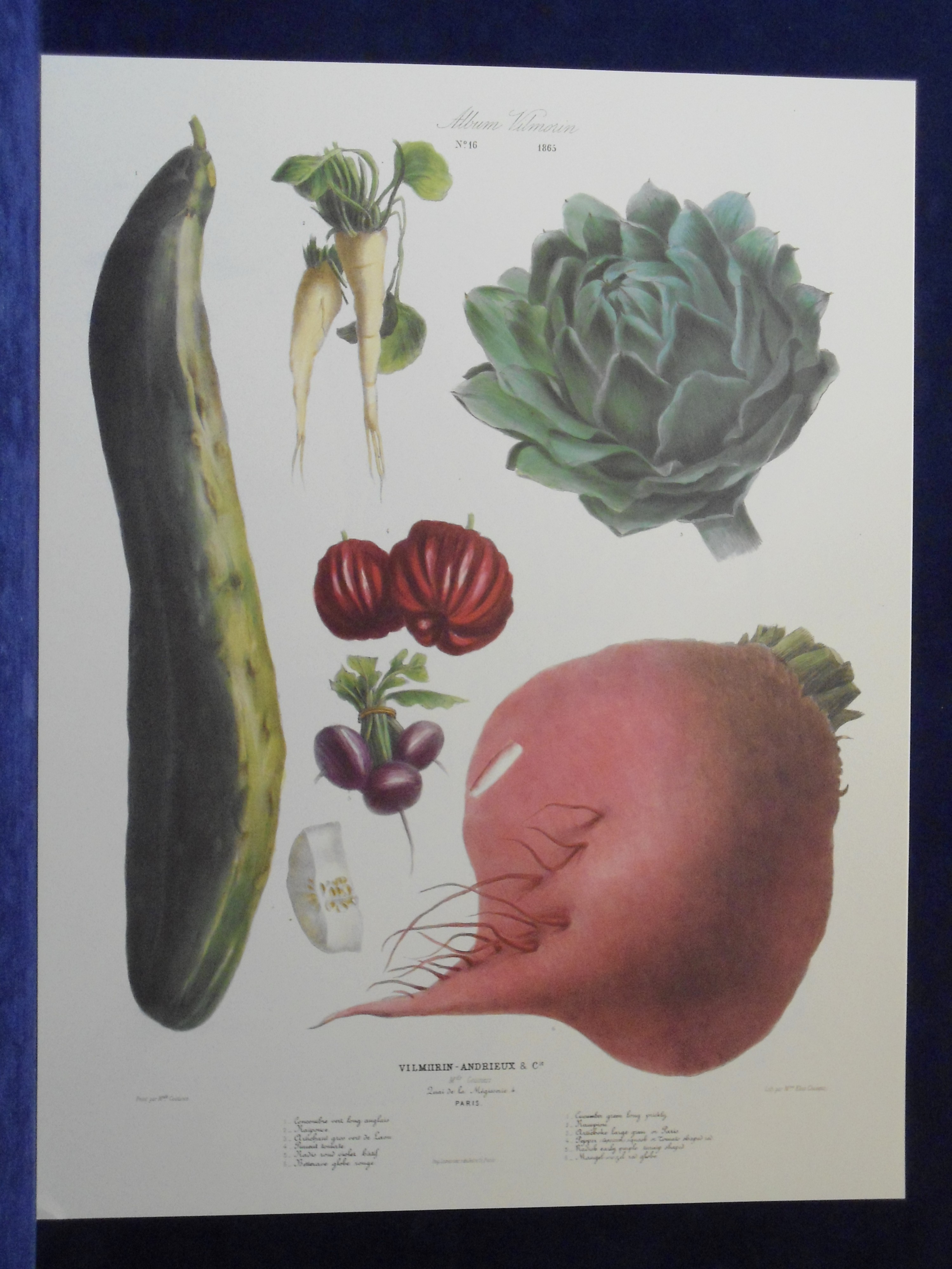
Album Vilmorin 1865. No 16
Vilmorin-Andrieux & C.ie. M.ds Grainiers. Quai de la Mégisserie 4. Paris.
Peint par M.lle Coutance.
Lith. par M.lle Elisa Champin.
Imp. Lemercier, r. de Seine 57. Paris.
Faksimil. Färgtryckt plansch, ur Album Vilmorin, Le Jardin Potager - The Vegetable Garden.
Originalet ritat och mĺlat av Coutance.
Litograferat av Elisa Champin
Storlek: 49x63 cm, planschytans bredd x höjd.
Gurka, kronärtskocka, peppar, rädisa, mangold och rapunkel.
Pris: 400 SEK - 39935 - Se bild.
- - -
Vid köp av fyra, betala endast för tre.
