
'Geologic Atlas of the United States. Jackson Folio. California.' - Washington D.C. 1894.
Department of the Interior. United States Geological Survey. J. W. Powell, Director.
Washington D. C. Engraved and Printed by the U. S. Geological Survey. Bailey Willis, Editor of Geological maps. S. J. Kübel, Chief Engraver.
Flerfärgslitografi.
Mapp med text pĺ insidan samt ytterligare sex sidor text.
Fyra kartor, 'Topography', 'Areal Geology', 'Economic Geology', 'Structure Sections'.
Storlek: 48x55 cm. Mappens bredd x höjd.
Pris: 600 SEK - 26661
Nya Sverige. - P. Lindström, T. Campanius Holm 1655.
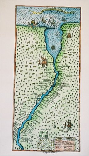
Nova Svecia hodie dicta Pennsylvania.
Anno 1654 och 1655 är denna Nove Svecie charta med dess Riviers och Landz situation ock beskaffenhet aftagen och till Carts förd af P. Lindström ingin. fortif..
Originalet frĺn Thomas Campanius Holms bok, 1702.
Faksimil pĺ akvarellpapper och helt handkolorerad.
Uppförstorad: 25x55 cm. Pris: 1.200:-
Originalstorlek: 17x36,5 cm. Pris: 900:-
Pris: 900 SEK - 26645 - Se bild.
'New Map of Boston...' - 1883.
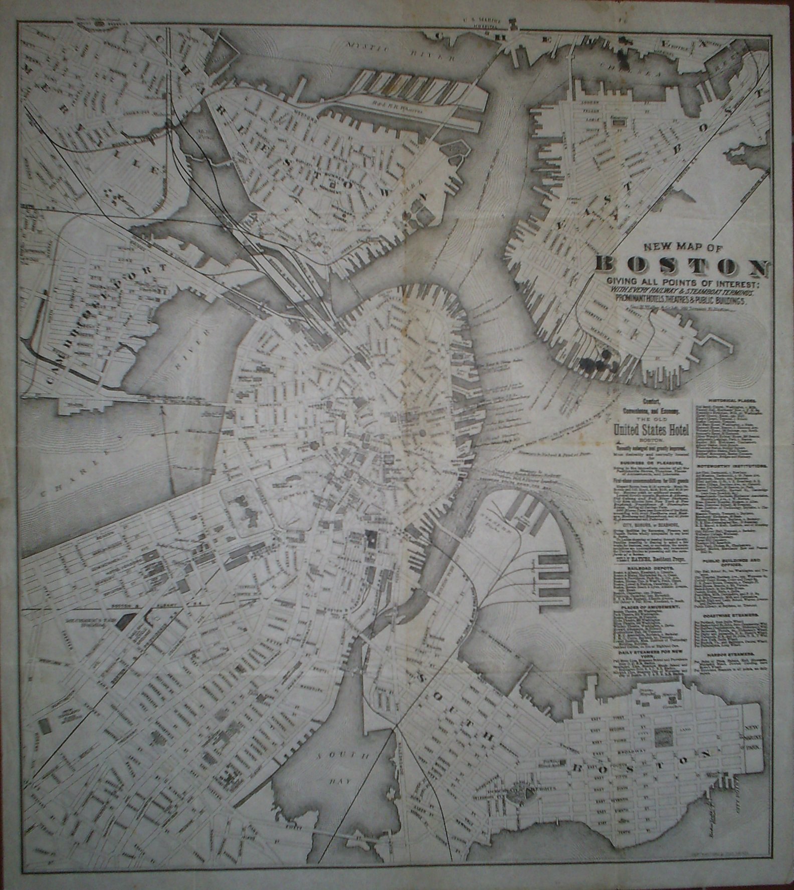
New Map of Boston giving all points of interest: with every railway & steamboat terminus, prominant hotels, theatres & public buildings.
Geo. H. Walker & Co Lith. 160 Tremont St. Boston.
Copyright 1883 by Tilly Haynes.
Litograferad karta.
Storlek: 44x49 cm. Kartytans bredd x höjd.
Kartan har varit vikt. Med smĺhĺl i vikningen. Fyra smärre bläckfläckar under titeln samt tre stycken i kartans övre kant. Svag bruntoning i mittvecket.
Karta över Boston.
Pris: 2000 SEK - 26650 - Se bild.
Med reklam för 'The Old United States Hotel Boston' samt lista över kommunikationer, sevärdheter, historiska platser med mera.
'Geologic Atlas of the United States. Chattanooga Folio. Tennessee.' - Washington D.C. 1894.
Department of the Interior. United States Geological Survey. J. W. Powell, Director.
Washington D. C. Engraved and Printed by the U. S. Geological Survey. Bailey Willis, Editor of Geological maps. S. J. Kübel, Chief Engraver.
Flerfärgslitografi.
Mapp med text pĺ insidan samt ytterligare fyra sidor text.
Fyra kartor, 'Topography', 'Areal Geology', 'Economic Geology', 'Structure Sections'.
En tabell, 'Columnar Sections'.
Storlek: 48x55 cm. Mappens bredd x höjd.
Pris: 600 SEK - 26658
'Cataracte de Niagara.' - 1700-tal.
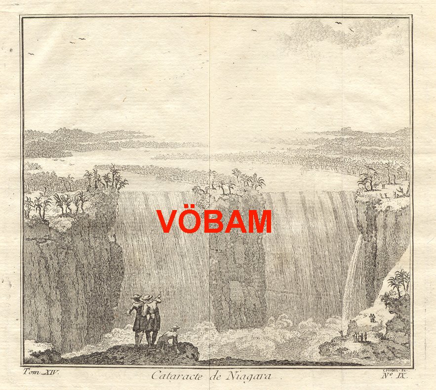
Cataracte de Niagara.
Koppargraverad vy.
Storlek: 14x13 cm. Bildytans bredd x höjd.
Bilden har varit vikt.
Vy över Niagarafallen.
Pris: 800 SEK - 26651 - Se bild.
Department of the Interior. United States Geological Survey. J. W. Powell, Director.
Washington D. C. Engraved and Printed by the U. S. Geological Survey. Bailey Willis, Editor of Geological maps. S. J. Kübel, Chief Engraver.
Flerfärgslitografi.
Mapp med text pĺ insidan samt ytterligare sex sidor text.
Fyra kartor, 'Topography', 'Areal Geology', 'Economic Geology', 'Structure Sections'.
En tabell, 'Columnar Sections'.
Storlek: 48x55 cm. Mappens bredd x höjd.
Pris: 600 SEK - 26660
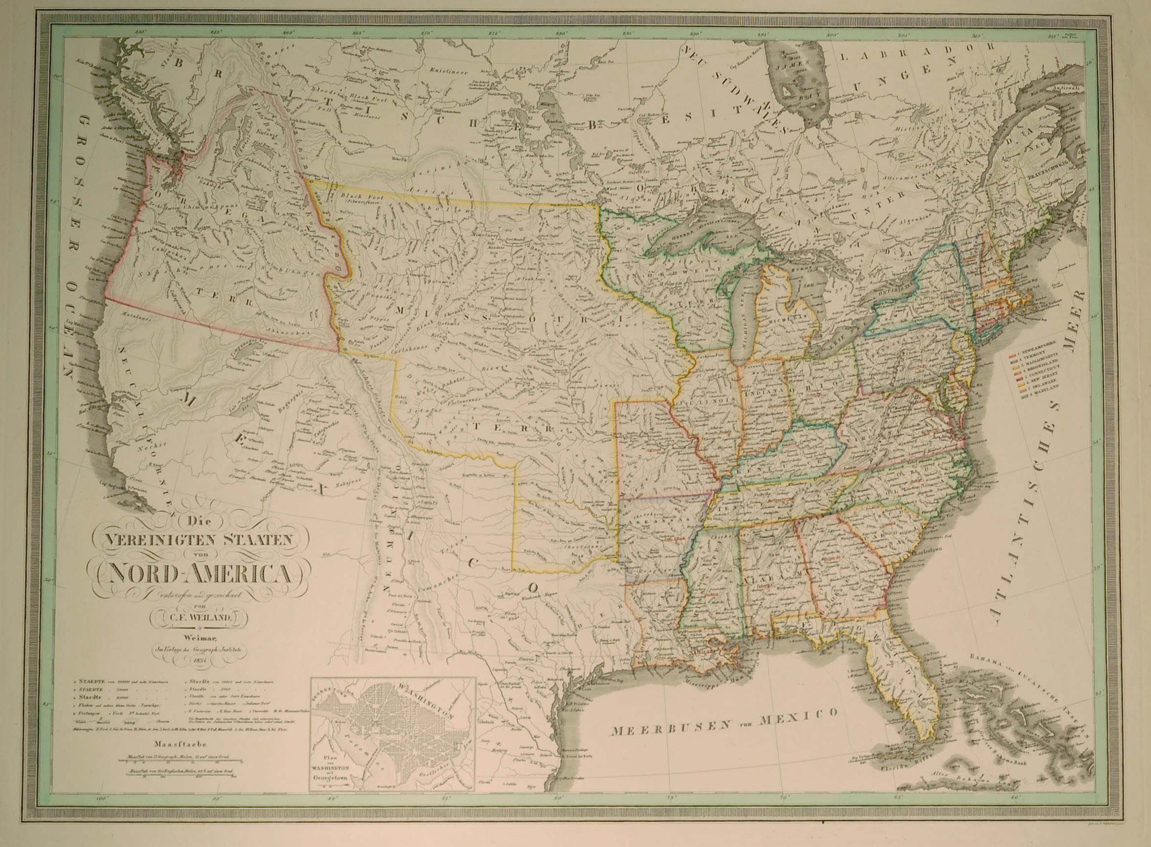
Die VEREINIGTEN STAATEN von NORD-AMERICA
Eentworfen und gezeichnet von C. F. Wieland.
Infälld karta: 'Plan von Washington mit Georgetown.'
Weimar 1834. Verlage des Geograph. Instituts.
Storlek: 62x46 cm.
Kraftfull gränskolorering.
Pris: 4000 SEK - 26075 - Se bild.
'Geologic Atlas of the United States. Sacramento Folio. California.' - Washington D.C. 1894.
Department of the Interior. United States Geological Survey. J. W. Powell, Director.
Washington D. C. Engraved and Printed by the U. S. Geological Survey. Bailey Willis, Editor of Geological maps. S. J. Kübel, Chief Engraver.
Flerfärgslitografi.
Mapp med text pĺ insidan samt ytterligare fyra sidor text.
Fyra kartor, 'Topography', 'Areal Geology', 'Economic Geology', 'Structure Sections'.
Storlek: 48x55 cm. Mappens bredd x höjd.
Pris: 600 SEK - 26662
'Geologic Atlas of the United States. Kingston Folio. Tennessee.' - Washington D.C. 1894.
Department of the Interior. United States Geological Survey. J. W. Powell, Director.
Washington D. C. Engraved and Printed by the U. S. Geological Survey. Bailey Willis, Editor of Geological maps. S. J. Kübel, Chief Engraver.
Flerfärgslitografi.
Mapp med text pĺ insidan samt ytterligare fyra sidor text.
Fyra kartor, 'Topography', 'Areal Geology', 'Economic Geology', 'Structure Sections'.
En tabell, 'Columnar Sections'.
Storlek: 48x55 cm. Mappens bredd x höjd.
Pris: 600 SEK - 26657
'Habits et Maisons des Floridiens.' - 1700-talets mitt.
Habits et Maisons des Floridiens.
Koppargraverad bild.
Storlek: 7x12 cm. Bildytans bredd x höjd.
Bild pĺ människor, hus och palmer i Florida.
Pris: 500 SEK - 26652

Vägvisare för XI Olympiaden i Berlin - 1936

Novaja Zemlja 'Carte du Détroit de Waeigats...' - J. N. Bellin 1758.
USA. - 1903-1913. - ur Le Petit Journal.
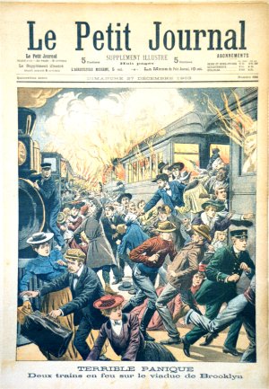
USA
4 första-sidor 1903-1913 och 6 supplement-sidor utan ĺrtal.
Totalt 10 motiv.
Storlek: 30x42 cm. Omväxlande stĺende och liggande.
Pris: 2000 SEK - 26655 - Se bild.
Amerika - Nordamerika - USA -
Le Petit Journal, morgontidning i Paris och länge en av de 'fyra stora'. Grundad 1863. Pĺ 1930-talet nationalistiskt eldkorsorgan. Tidningen upphörde i samband med andra världskriget.
Bilderna/motiven är klart kitschiga och det är just pĺ grund av detta som de blir mer och mer eftersökta.
